Corn Exchange, Witney

Last updated

Corn Exchange, Witney
The Corn Exchange in Witney (geograph 7194449).jpg
Corn Exchange, Witney
LocationMarket Street, Witney
Coordinates 51°47′03″N1°29′06″W / 51.7843°N 1.4849°W / 51.7843; -1.4849
Built1863
ArchitectJohn Collier
Architectural style(s) Neoclassical style
Listed Building – Grade II
Official nameCorn Exchange
Designated6 February 1970
Reference no.1289140
Oxfordshire UK location map.svg
Red pog.svg
Shown in Oxfordshire

The Corn Exchange is a commercial building in Market Street, Witney, Oxfordshire, England. The structure, which is used as a public events venue, is a Grade II listed building. [1]

Contents

History

Until the mid-19th century, corn merchants traded from the ground floor of Witney Town Hall. In the early 1860s, a group of local businessmen decided to form a company, to be known as the "Witney Corn Exchange and Public Rooms Company", to finance and commission a purpose-built corn exchange for the town. The site they chose in Market Street had accommodated the "Corn Returns Office", a structure, which was designed in the Tudor style using timber-frame construction, and which dated from 1593. [2]

The new building was designed by John Collier of Putney in the neoclassical style, built by a local builder, Malachi Bartlett, in ashlar stone at a cost of £2,500 and was officially opened on 17 September 1863. The design involved a symmetrical main frontage of three bays facing onto Market Street. The central bay featured a round headed doorway with a fanlight and a rusticated surround. There was a cross-window, with a segmental pediment and a balcony, supported by brackets, on the first floor. The outer bays were fenestrated by segmental headed sash windows with rusticated architraves on the ground floor and by square headed sash windows with cornices on the first floor. At roof level there was an entablature inscribed with the words "Corn Exchange", a modillioned cornice and a central pediment. The central pediment contained a clock, which was flanked by pairs of pilasters, in the tympanum. Internally, the principal room was the main hall which was 70 feet (21 m) long and 35 feet (11 m) wide. [3]

The use of the building as a corn exchange declined significantly in the wake of the Great Depression of British Agriculture in the late 19th century. [4] After the area was advanced to the status of urban district in 1895, [5] the new civic leaders decided to hold their meetings in the corn exchange, rather than in Witney Town Hall. [3] The council went on to raise the necessary money to acquire the corn exchange, after the Witney Corn Exchange and Public Rooms Company was placed into liquidation in January 1911. [6]

During the First World War the local branch of the Volunteer Training Corps used the corn exchange for drill practice on a weekly basis. [7] Witney Urban District Council relocated from the corn exchange to a large Victorian era property at 26 Church Green in 1936. [8] [9] During the Second World War, the corn exchange was requisitioned for use as an entertainment place for soldiers and was also used by the council for fund raising in support of War Weapons Week. [10]

The building became very dilapidated in the 1960s and was closed for public use in 1968. A local petition was initiated, demanding that the building be restored, in the 1970s. Witney Town Council acquired the corn exchange in July 1977: an extensive programme of refurbishment works costing £150,000 was carried out and the building was re-opened by the mayor, Michael Chadwick, in February 1979. [11] The building was remodelled internally, to enable the ground floor to be used as a cinema, in 1992. [3] Two programmes from the BBC Radio 4 show, Gardeners' Question Time , were recorded in the building in February 2004. [12] The ground floor was further upgraded when tiered seating was installed in 2022, enabling the building to be re-opened by the mayor, Liz Duncan, as an arts and performance hub in March 2023. [13]

See also

Related Research Articles

<span class="mw-page-title-main">Witney</span> Human settlement in England

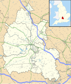
Witney is a market town on the River Windrush in West Oxfordshire in the county of Oxfordshire, England. It is 12 miles (19 km) west of Oxford. The place-name "Witney" is derived from the Old English for "Witta's island". The earliest known record of it is as Wyttannige in a Saxon charter of 969. The Domesday Book of 1086 records it as Witenie.

<span class="mw-page-title-main">Curbridge, Oxfordshire</span> Human settlement in England

Curbridge is a village and civil parish immediately southwest of Witney, in the West Oxfordshire district, in the county of Oxfordshire, England. The 2011 Census recorded the parish's population as 529. Since 2012 it has been part of the Curbridge and Lew joint parish council area, sharing a parish council with the adjacent civil parish of Lew.

<span class="mw-page-title-main">Ducklington</span> Human settlement in England

Ducklington is a village and civil parish on the River Windrush 1 mile (1.6 km) south of Witney in West Oxfordshire. The 2011 Census recorded the parish's population as 1,581.

<span class="mw-page-title-main">Bampton, Oxfordshire</span> Human settlement in England

Bampton, also called Bampton-in-the-Bush, is a settlement and civil parish in the Thames Valley about 4+12 miles (7 km) southwest of Witney in Oxfordshire. The parish includes the hamlet of Weald. The 2011 Census recorded the parish's population as 2,564. Bampton is variously referred to as both a town and a village. The Domesday Book recorded that it was a market town by 1086. It continued as such until the 1890s. It has both a town hall and a village hall.

<span class="mw-page-title-main">Standlake</span> Human settlement in England

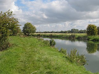
Standlake is a village and civil parish in West Oxfordshire about 5 miles (8 km) southeast of Witney and 7 miles (11 km) west of Oxford, England. The parish includes the hamlet of Brighthampton. The 2011 Census recorded the parish's population as 1,497. The River Windrush flows past the village and with its tributary Medley Brook it forms much of the eastern boundary of the parish. The western boundary has been subject to changes and disputes in past centuries. It now follows Brighthampton Cut, an artificial land drain dug in the 19th century. The Windrush joins the River Thames at Newbridge just over 1 mile (1.6 km) to the south.

<span class="mw-page-title-main">Cokethorpe School</span> Independent day school in Oxfordshire, Oxfordshire, England

Cokethorpe School is an independent day school in Hardwick, West Oxfordshire. Founded in 1957 by Francis Brown, it is a member of HMC, IAPS, and The Society of Heads. The school has approximately 660 students aged 4 to 18.

<span class="mw-page-title-main">Yelford</span> Human settlement in England

Yelford is a hamlet in Hardwick-with-Yelford civil parish. It is about 3 miles (5 km) south of Witney.

<span class="mw-page-title-main">Aston, Oxfordshire</span> Human settlement in England

Aston is a village about 4 miles (6.4 km) south of Witney in West Oxfordshire, England. The village is part of the civil parish of Aston, Cote, Shifford and Chimney. The southern boundary of the parish is the River Thames. The 2011 Census recorded the parish's population as 1,374.

<span class="mw-page-title-main">Chimney, Oxfordshire</span> Human settlement in England

Chimney is a hamlet on the River Thames near Shifford Lock, 6 miles (9.7 km) south of Witney in Oxfordshire. It is part of the civil parish of Aston, Cote, Shifford and Chimney. Chimney Meadows 620 acres (250 ha) is the largest nature reserve managed by the Berkshire, Buckinghamshire and Oxfordshire Wildlife Trust.

Brighthampton is a hamlet about 4 miles (6.4 km) south of Witney in West Oxfordshire and contiguous with the village of Standlake.

<span class="mw-page-title-main">Lew, Oxfordshire</span> Human settlement in England

Lew is a village and civil parish about 2+12 miles (4 km) southwest of Witney in the West Oxfordshire District of Oxfordshire, England. The 2001 Census recorded the parish population as 65. Since 2012 the parish has been part of the Curbridge and Lew joint parish council area, sharing a parish council with the adjacent civil parish of Curbridge.

<span class="mw-page-title-main">Shifford</span> Human settlement in England

Shifford is a hamlet in the civil parish of Aston, Cote, Shifford and Chimney in Oxfordshire, England. It is on the north bank of the River Thames about 6 miles (10 km) south of Witney.

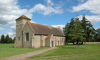
Weald is a hamlet in Bampton civil parish in Oxfordshire, England. It lies about 0.7 miles (1.1 km) southwest of Bampton. The toponym Weald is from the Old English for "woodland". The place was recorded by name in the late 12th century when Osney Abbey acquired a house there. It was a separate township by the 13th century. In the 18th and 19th centuries the township included much of the southwest part of the town of Bampton itself. A large late 17th century manor house, Weald Manor, was remodelled at around 1730. It is a Grade II* listed building.

Clapton Crabb Rolfe was an English Gothic Revival architect whose practice was based in Oxford.

<span class="mw-page-title-main">William Wilkinson (architect)</span> British architect (1819–1901)

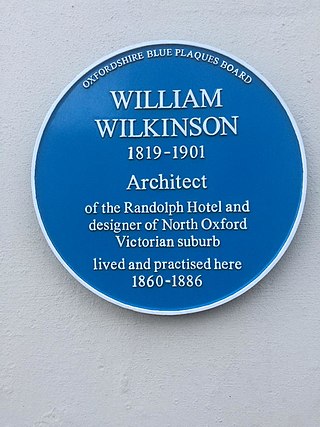
William Wilkinson (1819–1901) was a British Gothic Revival architect who practised in Oxford, England.

Hardwick-with-Yelford is a civil parish in West Oxfordshire. The parish includes the villages of Hardwick and Yelford. It was formed in 1932 from the parish of Yelford, most of the parish of Hardwick, and parts of the parishes of Ducklington and Standlake.

<span class="mw-page-title-main">Hardwick, West Oxfordshire</span> Human settlement in England

Hardwick is a village in the civil parish of Hardwick-with-Yelford in West Oxfordshire. The village is on the A415 road about 2.5 miles (4 km) southeast of Witney. It lies on the river Windrush. Hardwick was historically a hamlet or chapelry in the ancient parish of Ducklington. It became a separate civil parish in 1866. In 1932 the parish was merged with the parish of Yelford and large parts of the parishes of Ducklington and Standlake to form the civil parish of Hardwick-with-Yelford.

<span class="mw-page-title-main">Witney Town Hall</span> Municipal building in Witney, Oxfordshire, England

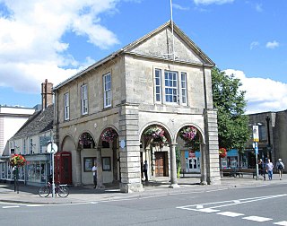
Witney Town Hall is a municipal structure in Spring Lane in Market Square, Witney, Oxfordshire, England. The town hall, which is the headquarters of Witney Town Council, is a Grade II* listed building.

<span class="mw-page-title-main">Woodstock Town Hall</span> Municipal building in Woodstock, Oxfordshire, England

Woodstock Town Hall is a municipal building in the Market Place in Woodstock, Oxfordshire, England. The building, which is used as a community events venue, is a Grade II listed building.

<span class="mw-page-title-main">Bampton Town Hall</span> Municipal building in Bampton, Oxfordshire, England

Bampton Town Hall is a municipal building in the Market Square in Bampton, Oxfordshire, England. The building, which is primarily used as an arts centre, is a Grade II listed building.

References

  1. Historic England. "Corn Exchange (1289140)". National Heritage List for England . Retrieved 12 June 2023.
  2. Clapton, Adam (2015). "Witney Corn Exchange, 1863–2015 A Brief History" (PDF). Witney Town Council. p. 3. Retrieved 12 June 2023.
  3. 1 2 3 Baggs, A. P.; Chance, Eleanor; Colvin, Christina; Cooper, Nicholas; Crossley, Alan; Day, Christopher; Selwyn, Nesta; Williamson, Elizabeth; Yates, Margaret (2004). "'Witney borough: Introduction, Architecture and Buildings', in A History of the County of Oxford: Volume 14, Bampton Hundred (Part Two), ed. Simon Townley". London: British History Online. pp. 33–68. Retrieved 12 June 2023.
  4. Fletcher, T. W. (1973). 'The Great Depression of English Agriculture 1873-1896' in British Agriculture 1875-1914. London: Methuen. p. 31. ISBN   978-1136581182.
  5. "Witney UD". Vision of Britain. Retrieved 25 April 2021.
  6. "No. 28457". The London Gazette . 17 January 1911. p. 437.
  7. Clapton (2015), p. 32
  8. Baggs, A. P.; Chance, Eleanor; Colvin, Christina; Cooper, Nicholas; Crossley, Alan; Day, Christopher; Selwyn, Nesta; Williamson, Elizabeth; Yates, Margaret (2004). "'Witney borough: Local Government, in A History of the County of Oxford: Volume 14, Bampton Hundred (Part Two), ed. Simon Townley". London: British History Online. pp. 111–130. Retrieved 25 April 2021.
  9. "No. 38920". The London Gazette . 23 May 1950. p. 2577.
  10. Clapton (2015), p. 38
  11. Clapton (2015), p. 48
  12. "Popular gardening show comes to town". Oxford Mail. 31 January 2004. Retrieved 12 June 2023.
  13. "Witney Corn Exchange theatre transformed into arts and performance hub". Oxford Mail. 1 March 2023. Retrieved 12 June 2023.