Cornwall, Pennsylvania

Last updated
Cornwall, Pennsylvania
Borough
CornwallFurnacePA.jpg
Lebanon County Pennsylvania Incorporated and Unincorporated areas Cornwall Highlighted.svg
Location in Lebanon County, Pennsylvania
USA Pennsylvania location map.svg
Red pog.svg
Cornwall
Location in Pennsylvania
Usa edcp location map.svg
Red pog.svg
Cornwall
Location in the United States
Coordinates: 40°16′23″N76°24′38″W / 40.27306°N 76.41056°W / 40.27306; -76.41056
Country United States
State Pennsylvania
County Lebanon
Settled1734
Incorporated1926
Government
  TypeBorough Council
  Council PresidentCarl Hilton (R)
Area
[1]
  Total9.76 sq mi (25.27 km2)
  Land9.70 sq mi (25.13 km2)
  Water0.05 sq mi (0.14 km2)
Elevation
554 ft (169 m)
Population
 (2020) [2]
  Total4,604
  Density474.49/sq mi (183.20/km2)
Time zone UTC-5 (Eastern (EST))
  Summer (DST) UTC-4 (EDT)
ZIP code
17016
Area code 717
FIPS code 42-16256
Website www.cornwall-pa.com

Cornwall is a borough in Lebanon County, Pennsylvania, United States. It is part of the Lebanon, PA Metropolitan Statistical Area. The population was 4,604 at the 2020 census. [3]

Contents

History

Cornwall was initially settled by Peter Grubb in 1734. [4] Peter was a Chester County stonemason who came to, what was then Lancaster County, in search of high quality stone for quarrying. First building his house and then a store, he discovered magnetite iron ore nearby and decided to test its quality, he found the ore to be exceedingly pure. Grubb wrote to Philadelphia and in 1734 was granted a warrant to purchase 300 acres (1.2 km2) of land. For three years Peter followed veins of ore until he found a large deposit that was easily accessible; however, this ore was not within the bounds of his property. So in 1737 he purchased an additional 142.5 acres (0.577 km2) of land. [5] In 1742 Peter built a cold blast furnace and named it Cornwall, after his father's birthplace in England. The Cornwall Iron Mine was, at one time, the largest open-pit mining operation in the world. They were mined continuously until June 30, 1973, totaling 236 years of production. [6]

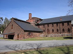
Finding the necessary components nearby for smelting iron (water, limestone and timber for charcoal), Grubb built the Cornwall Iron Furnace and began production in 1742. The operation also included the Hopewell Forges on nearby Hammer Creek. Peter Grubb did not stay long to run the operation, but leased it out in 1745 for 20 years and returned to Wilmington, Delaware. In 1765 Peter's sons Curtis and Peter Jr. took over the operation, and in 1798 it passed to Robert Coleman and his family. Cornwall Furnace was in production from 1742 until 1883, and appears today much as it was when production ended. In 1932 the Coleman family deeded the property to the Commonwealth of Pennsylvania and it is now a designated National Historic Landmark open to the public. [7]

Eventually the whole town became known as Cornwall. It was incorporated as a borough on October 11, 1926, after having been a part of Lancaster County and for a while of Dauphin County. At the time it officially became a borough, it comprised six widely separated villages. [8]

Alden Villa was added to the National Register of Historic Places in 2011. [9]

Geography

Cornwall is located at 40°16′23″N76°24′38″W / 40.27306°N 76.41056°W / 40.27306; -76.41056 (40.273192, -76.410667). [10]

According to the United States Census Bureau, the borough has a total area of 9.9 square miles (26 km2), of which 9.8 square miles (25 km2) is land and 0.1 square miles (0.26 km2) (1.11%) is water.

Demographics

Historical population
CensusPop.Note
1930 1,837
1940 1,680−8.5%
1950 1,7604.8%
1960 1,9349.9%
1970 2,1119.2%
1980 2,65325.7%
1990 3,23121.8%
2000 3,4867.9%
2010 4,11218.0%
2020 4,60412.0%
Sources: [11] [12] [13] [2]

As of the census [12] of 2000, there were 3,486 people, 1,210 households, and 965 families residing in the borough. The population density was 357.2 inhabitants per square mile (137.9/km2). There were 1,261 housing units at an average density of 129.2 units per square mile (49.9 units/km2). The racial makeup of the borough was 97.79% White, 0.34% African American, 0.20% Native American, 1.06% Asian, 0.32% from other races, and 0.29% from two or more races. Hispanic or Latino of any race were 0.75% of the population.

There were 1,210 households, out of which 32.6% had children under the age of 18 living with them, 71.9% were married couples living together, 4.4% had a female householder with no husband present, and 20.2% were non-families. 17.5% of all households were made up of individuals, and 9.1% had someone living alone who was 65 years of age or older. The average household size was 2.58 and the average family size was 2.91.

In the borough the population was spread out, with 20.9% under the age of 18, 4.9% from 18 to 24, 22.7% from 25 to 44, 28.1% from 45 to 64, and 23.5% who were 65 years of age or older. The median age was 46 years. For every 100 females there were 89.7 males. For every 100 females age 18 and over, there were 82.9 males.

The median income for a household in the borough was $59,550, and the median income for a family was $66,964. Males had a median income of $44,926 versus $28,125 for females. The per capita income for the borough was $27,904. About 1.1% of families and 1.7% of the population were below the poverty line, including 1.0% of those under age 18 and 4.2% of those age 65 or over.

Related Research Articles

<span class="mw-page-title-main">Etna, Pennsylvania</span> Borough in Pennsylvania, United States

Etna is a borough in Allegheny County, Pennsylvania, United States, located across the Allegheny River from Pittsburgh. The population was 3,437 at the 2020 census. It is a suburb of the Pittsburgh metropolitan area.

<span class="mw-page-title-main">Worthington, Pennsylvania</span> Borough in Pennsylvania, United States

Worthington is a borough in Armstrong County, Pennsylvania, United States. The population was 594 at the 2020 census.

<span class="mw-page-title-main">Leesport, Pennsylvania</span> Borough in Pennsylvania, United States

Leesport is a borough in Berks County, Pennsylvania, United States. The population was 1,954 at the 2020 census.

<span class="mw-page-title-main">Robesonia, Pennsylvania</span> Borough in Pennsylvania, United States

Robesonia is a borough that is located in Berks County, Pennsylvania, United States. The population was 2,035 at the time of the 2020 census.

<span class="mw-page-title-main">Vintondale, Pennsylvania</span> Borough in Pennsylvania, United States

Vintondale is a borough in Cambria County, Pennsylvania, United States. It is part of the Johnstown, Pennsylvania Metropolitan Statistical Area. The population was 414 as of the 2010 census.

<span class="mw-page-title-main">Parryville, Pennsylvania</span> Borough in Pennsylvania, United States

Parryville is a borough in Carbon County, Pennsylvania, United States. It is part of Northeastern Pennsylvania, and is located 3 miles (5 km) southeast of Lehighton and 1 mile (1.6 km) north of Bowmanstown, off Route 248 and 4 miles (6 km) northwest of Palmerton.

<span class="mw-page-title-main">Milesburg, Pennsylvania</span> Borough in Pennsylvania, United States

Milesburg is a borough in Centre County, Pennsylvania. It is part of the State College, Pennsylvania metropolitan statistical area. The population was 1,093 at the 2020 census.

<span class="mw-page-title-main">Patton Township, Pennsylvania</span> Township in Pennsylvania, United States

Patton Township is a township in Centre County, Pennsylvania, United States. It is part of the State College, Pennsylvania Metropolitan Statistical Area. The population was 15,801 at the 2020 census, which is a 3.2% increase from the 2010 census.

<span class="mw-page-title-main">Elk Township, Clarion County, Pennsylvania</span> Township in Pennsylvania, United States

Elk Township is a township in Clarion County, Pennsylvania, United States. The population was 1,432 at the 2020 census, a decrease from the figure of 1,490 tabulated in 2010.

<span class="mw-page-title-main">Catawissa Township, Pennsylvania</span> Township in Pennsylvania, United States

Catawissa Township is a township near the borough of Catawissa, Columbia County, Pennsylvania. It is part of Northeastern Pennsylvania. The population was 904 at the 2020 census.

<span class="mw-page-title-main">Mount Holly Springs, Pennsylvania</span> Borough in Pennsylvania, United States

Mount Holly Springs is a borough in Cumberland County, Pennsylvania, United States. The borough is located 25 miles north of Gettysburg. The population was 2,030 at the 2010 census. It is part of the Harrisburg–Carlisle metropolitan statistical area.

<span class="mw-page-title-main">Fairchance, Pennsylvania</span> Borough in Pennsylvania, United States

Fairchance is a borough in Fayette County, Pennsylvania, United States. The population was 1,889 at the 2020 census, a decline from the figure of 1,975 tabulated in 2010. It is served by the Albert Gallatin Area School District.

<span class="mw-page-title-main">Metal Township, Pennsylvania</span> Township in Pennsylvania, United States

Metal Township is a township that is located in Franklin County, Pennsylvania, United States. The population was 1,768 at the time of the 2020 census.

<span class="mw-page-title-main">Penn Township, Huntingdon County, Pennsylvania</span> Township in Pennsylvania, United States

Penn Township is a township in Huntingdon County, Pennsylvania, United States. The population was 1,078 at the 2020 census. The township includes the village of Hesston and the Seven Points Marina of Raystown Lake.

<span class="mw-page-title-main">Rockhill, Pennsylvania</span> Borough in Pennsylvania, United States

Rockhill or Rockhill Furnace is a borough in Huntingdon County, Pennsylvania, United States. The population was 371 at the 2010 census, down from 414 at the 2000 census. It is the site of the East Broad Top Railroad and the Rockhill Trolley Museum.

<span class="mw-page-title-main">Elizabeth Township, Lancaster County, Pennsylvania</span> Township in Pennsylvania, United States

Elizabeth Township is a township in north central Lancaster County, Pennsylvania, United States. The population was 3,998 at the 2020 census.

<span class="mw-page-title-main">Coplay, Pennsylvania</span> Borough in Pennsylvania, United States

Coplay is a borough in Lehigh County, Pennsylvania, United States. Coplay's population was 3,348 at the 2020 census. It is located six miles (10 km) northwest of Allentown. The borough is part of the Lehigh Valley metropolitan area, which had a population of 861,899 and was the 68th-most populous metropolitan area in the U.S. as of the 2020 census.

<span class="mw-page-title-main">McIntyre Township, Pennsylvania</span> Township in Pennsylvania, United States

McIntyre Township is a township in Lycoming County, Pennsylvania, United States. The population was 460 at the 2020 census. It is part of the Williamsport Metropolitan Statistical Area.

<span class="mw-page-title-main">Watson Township, Lycoming County, Pennsylvania</span> Township in Pennsylvania, United States

Watson Township is a township in Lycoming County, Pennsylvania, United States. The population was 534 at the 2020 census. It is part of the Williamsport Metropolitan Statistical Area.

Peter Grubb (c.1702—1754), the founder of the Grubb Family Iron Dynasty, discovered Cornwall Iron Mines and established Cornwall Iron Furnace, together one of the largest ironworks in Colonial Pennsylvania. The Cornwall Iron Mines are the largest U.S. iron mines ever discovered east of Lake Superior.

References

  1. "ArcGIS REST Services Directory". United States Census Bureau. Retrieved October 12, 2022.
  2. 1 2 "Census Population API". United States Census Bureau. Retrieved Oct 12, 2022.
  3. Bureau, US Census. "City and Town Population Totals: 2020-2021". Census.gov. US Census Bureau. Retrieved 9 July 2022.
  4. Dieffenbach, Susan (2003-01-01). Cornwall Iron Furnace: Pennsylvania Trail of History Guide. Stackpole Books. ISBN   9780811726245.
  5. Oblinger, Carl D.; Commission, Pennsylvania Historical and Museum (1984-06-01). Cornwall: the people and culture of an industrial Camelot, 1890-1980. Commonwealth of Pennsylvania, Pennsylvania Historical and Museum Commission. ISBN   9780892710287.
  6. Boyer, Charles; Donley, Robert (2011-01-01). Cornwall. Arcadia Publishing. ISBN   9780738574653.
  7. Dieffenbach, Susan (2003). Cornwall Iron Furnace, Pennsylvania Trail of History Guide. Stackpole Books.
  8. "History of Cornwall". www.cornwall-pa.com.[ permanent dead link ]
  9. "National Register of Historic Places Listings". Weekly List of Actions Taken on Properties: 4/18/11 through 4/22/11. National Park Service. 2011-04-29.
  10. "US Gazetteer files: 2010, 2000, and 1990". United States Census Bureau. 2011-02-12. Retrieved 2011-04-23.
  11. "Census of Population and Housing". U.S. Census Bureau. Retrieved 11 December 2013.
  12. 1 2 "U.S. Census website". United States Census Bureau . Retrieved 2008-01-31.
  13. "Incorporated Places and Minor Civil Divisions Datasets: Subcounty Resident Population Estimates: April 1, 2010 to July 1, 2012". Population Estimates. U.S. Census Bureau. Archived from the original on 11 June 2013. Retrieved 11 December 2013.