Coronel Du Graty

Last updated

Coronel Du Graty
City
CountryFlag of Argentina.svg  Argentina
Province Flag of Chaco province in Argentina 2007.svg  Chaco
Department M. L. J. Fontana
Government
  MayorJuan Carlos Polini
Elevation
256 ft (78 m)
Population
 (2010)
  Total9,015
Demonym dugratense
Time zone UTC−3 (ART)
Postal Code
H3541
Area code 03735

Coronel Du Graty is a small city and municipality in Chaco Province in northern Argentina. [1] There is no foundation date but the name Coronel Du Graty was assigned by national decree on January 26, 1942 and this date is used as the foundation.

Contents

Name

The name of the Belgian Colonel Alfredo Marbais, Baron Du Graty, was awarded on January 26, 1942, by national decree 112.231, signed by Vice President Ramón Castillo, designating it the "railway station" in spot detour km 23.

History

The exact date of foundation, the name of the first settlers or the origin of the town's name is uncertain due to the lack of reliable documentation that certifies the facts and serves as sources to gather significant information about the origins of the town. What is certain is that the railway was the decisive element for the definitive settlement of the settlers and the formation of this locality.2

Some mention that this place was first called Paraje "Ñandubay", then the first settlement was known as "Fortín Encrucijada", and finally "Coronel Du Graty" which prospered through a decree of the national government.

Fortin Encrucijada

Very close to the present location of the locality of Coronel Du Graty there was a fort called Encrucijada located 10 kilometres away on the present Route N° 95 towards Villa Ángela, Encrucijada was part of the line of forts carried out by Manuel Obligado from Reconquista to subdue the aborigines of the Chaco territories. According to Carlos Primo López Piacentini, this fort was built by commander Juan José Rosetti in 1899. This fortified redoubt is the first construction in the parajes by the national government. It is the result of the lines and outposts of the expeditions carried out towards the centre of the Chaco territory. In the Chaco there were several expeditions divided into columns to achieve the definitive occupation of the Chaco and this fort played a fundamental role in its function of carrying out the definitive conquest of these territories.

The origin of this fort dates back to 17 August 1899, when the 6th Cavalry Regiment arrived at the 28th parallel, and built a fort which they called General Necochea, and which was garrisoned by four squadrons. One day two soldiers of the 6th regiment working outside the fort were attacked by a tiger, but one of the soldiers killed it with a blow; then they cut off its head and took it to the fort, where they placed it on a stake at the entrance to the fort. Since then, when they referred to the aforementioned fort, they did so by saying: "el cabeza de tigre" or Fortín "Cabeza del Tigre", whose name still persists today to refer to the place.

This Regiment, which had been commanded by Martín Hernández, was replaced by Commander Juan José Rosetti; with him it continued its advance towards the centre of the Chaco, creating the forts Potrero, Avanzada, Pasaje, Totoralito and Encrucijada, located in our current area of Coronel Du Graty and others. By 1910 the garrison consisted of 30 soldiers and 30 mules to travel through the area, through open trails in the bush.

For this reason, when the settled population reached a certain importance, one of the first names proposed for this town was Fortín Encrucijada, located in the area known as El Ñandubay. This name did not prosper because it was replaced in 1942 by the name of Coronel Du Graty proposed by the French Railway Company and ratified by a Decree of the National Government.

Arrival of the Railway

In order to facilitate the commercialisation of timber, in 1927, the railway line was extended from the city of Villa Ángela by the forestry company "La Chaqueña". In order to continue with the exploitation of timber in the fields of Zuberbhüler, El Ñandubay and Campo Ugarte, a railway line was extended up to Km 23 in the place that today occupies this town, which passed near the old fort Encrucijada. The inauguration of this branch line from Villa Ángela to Ñandubay took place on 29 May 1927. There are photographic testimonies of the baptism of the branch line that was made with a glass of champagne by María Antonia Zuccarelli daughter of Andrés Zuccarelli, manager of La Chaqueña between 1922 and 1947 and with the presence of the authorities of the company.

It was a network of decauvilles extended by La Chaqueña to works owned by him and other private individuals, which reached an extension of 75 kilometres, with the tannin factory as a starting point, through which the Santa Fe Railway passed. In this way, the transport of wood was facilitated and a "beach" was formed with a winch for the loading of timber or logs. As a result of this development, a nucleus of settlers was formed, the social and economic transformation of the area was rapid and the commercial movement acquired a certain importance. Mr. Victor Luis Goycochea established himself with a general store, who later leased part of Mr. Zuberbuhler's land with the purpose of using it for agriculture. Later, with the development of cotton cultivation in the area, the local cotton growers sent the raw cotton for industrialisation to other provinces. But later, with the opening of ginneries in the 1930s, bales and seed began to be transported by rail. As a consequence of the decline of the tannin towns located on the Santa Fe railway line, hundreds of families from the mills in that area moved towards km 95 of the Charadai branch line and settled in the fields in the Villa Ángela area.

Migrant boom

In the 1920s there was a massive influx of foreigners. Between 1914 and 1947, between 1914 and 1947, there was a vertiginous growth in population as a result of the laying of railway lines, the possibility of access to public lands and the cultivation of cotton. The settlement of Hungarian immigrants was particularly significant.

In 1936, during the month of October, Mr. Carlos and Mr. César Ugarte arranged for the survey of the land they owned to be used for the town. The survey was carried out by the Agronomist Martín Julio Ledesma. At first the town was given the name of Fortín Encrucijada, in homage to the army fort that existed in the fields of the area, of which there are currently no traces. We can only find out what it was like from a drawing in the historical book of school No. 197, which was made thanks to the description of Ramón Moyano, an old inhabitant of the area who knew it.

Imposition of the present name

In 1942, the French company that operated the railways requested the designation of names for the turnouts and stations located in different places. The file No. 3944, Letter O, of 1942 belonging to the Ministry of Public Works of the Argentine Republic records this request, and as the railway had already reached the place Fortín Encrucijada, the imposition of a name is requested and it is identified as "detour of Km 23" southwest of Villa Ángela.

For this reason, the vice-president of the Nation, Dr. Ramón Castillo, issued the decree N° 112.231 dated 26 January 1942, by means of which the name Coronel Du Graty was officially given to this place.

This name was proposed by the Advisory Board to the Railway Directorate in recognition of the services rendered to the country by this important military man of foreign origin.

Related Research Articles

<span class="mw-page-title-main">Chaco War</span> War between Bolivia and Paraguay (1932 to 1935)

The Chaco War was fought from 1932 to 1935 between Bolivia and Paraguay, over the control of the northern part of the Gran Chaco region of South America, which was thought to be rich in oil. The war is also referred to as La Guerra de la Sed in literary circles since it was fought in the semi-arid Chaco. The bloodiest interstate military conflict fought in South America in the 20th century, it was fought between two of its poorest countries, both of which had lost territory to neighbours in 19th-century wars.

<span class="mw-page-title-main">Chaco Province</span> Province of Argentina

Chaco, officially the Province of Chaco, is one of the 23 provinces in Argentina. Its capital and largest city, is Resistencia. It is located in the north-east of the country.

<span class="mw-page-title-main">Boquerón department</span> Department of Paraguay

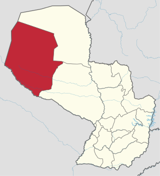
Boquerón is a department in the western region of Paraguay. It is the country's largest department, with an area of 91,669 km2 (35,394 sq mi), but, according to the statistics for 2021 by INE, its population is only 68,080, being the second least populated department. The department includes the Russian Mennonite colonies of Fernheim, Menno and its administrative center Loma Plata and Neuland. The capital is Filadelfia. Other towns are General Eugenio A. Garay, Doctor Pedro P. Peña and Mariscal Estigarribia.

<span class="mw-page-title-main">Presidente Hayes Department</span> Department of Paraguay

Presidente Hayes is a department in Paraguay. The capital is the city of Villa Hayes. The department was named after U.S. President Rutherford B. Hayes, who awarded the territory to Paraguay while arbitrating a boundary dispute between Paraguay and Argentina after the Paraguayan War.

<span class="mw-page-title-main">Puerto Casado</span> Place in Alto Paraguay, Paraguay

Puerto Casado is one of the 4 districts in Alto Paraguay Department, Paraguay. It includes the town of La Victoria or Puerto La Victoria, which has a population of around 7,800.

<span class="mw-page-title-main">Ayolas</span> District

Ayolas is a city in the department of Misiones, Paraguay, located at 310 km southeast of Asunción, on the banks of the Paraná River. It is, also, the name of the district within which the city is located.

<span class="mw-page-title-main">Villa Ángela</span> City in Chaco, Argentina

Villa Ángela is a city in the province of Chaco, Argentina, 186 km west of the provincial capital Resistencia. It is on the Gran Chaco, a lowland region of the Río de la Plata basin. It has 43,511 inhabitants as per the 2001 census [INDEC], making it the third largest in the province.

<span class="mw-page-title-main">Benito Juárez Partido</span> Department in Argentina

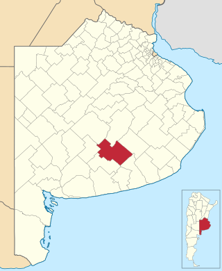
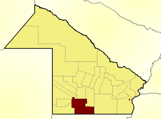
Benito Juárez is a partido in the south-central part of Buenos Aires Province in Argentina.

<span class="mw-page-title-main">Mayor Luis Jorge Fontana Department</span> Department in Chaco Province, Argentina

Mayor Luis Jorge Fontana is a southern department of Chaco Province in Argentina.

<span class="mw-page-title-main">Huixquilucan Municipality</span> Municipality in State of Mexico, Mexico

Huixquilucan Municipality is one of the municipalities in State of Mexico, Mexico. It lies adjacent to the west side of the Federal District and is part of Greater Mexico City but independent of Mexico City itself. The name "Huixquilucan" comes from Nahuatl meaning, "place full of edible thistles".

<span class="mw-page-title-main">General Manuel Belgrano Railway</span> Argentine state-owned railway company

The General Manuel Belgrano Railway (FCGMB), named after the Argentine politician and military leader Manuel Belgrano, is a 1,000 mmmetre gauge railway and the longest of the Argentine system. It was one of the six State-owned Argentine railway companies formed after President Juan Perón's nationalisation of the railway network in 1948.

<span class="mw-page-title-main">Province of Santa Fe Railway</span>

Province of Santa Fe Railway was a French-owned company that purchased a 1,000 mmmetre gauge railway network built by the provincial government of Santa Fe in Argentina on 10 April 1900 and later extended it in the provinces of Chaco and Córdoba. After nationalisation in 1948 it became part of the state-owned company Belgrano Railway

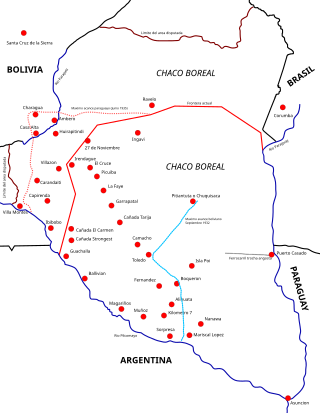
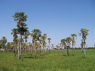
The Gran Chaco is a plain of about 1.000.000 km2. It covers parts of Bolivia, Paraguay, Brazil and Argentina.

<span class="mw-page-title-main">Mapastepec</span> Municipality in Chiapas, Mexico

Mapastepec is a town and municipality in the Mexican state of Chiapas in southern Mexico. Its name derives from the place name mapachtepec, "Hill of the Raccoon", a compound of the Nahuatl words mapachi ("raccoon") and tepetl ("mountain").

<span class="mw-page-title-main">La Escondida, Chaco</span> Municipality and village in Chaco Province, Argentina

La Escondida is a village and municipality in Chaco Province in northern Argentina La Escondida in the region of Chaco with its 3,948 residents is located in Argentina - some 522 miles (840 km) north of Buenos Aires.

Pichanal is a town and municipality in Orán Department, located in northeastern Salta Province, Argentina. It is connected to the national road network by National Route 34, and to nearby San Ramón de la Nueva Orán by National Route 50. It has economic significance because of its position as a junction on these routes. It is within the bounds of the Yungas Biosphere Reserve.

The Forestal Land, Timber and Railways Company Limited, commonly known as La Forestal, was a British forestry company that operated in the region between the southern Chaco and northern Santa Fe provinces in Argentina. During the late 19th and early 20th centuries, La Forestal exploited the extensive quebracho forests in these provinces, becoming the leading global producer of tannin. The company played a significant role in establishing approximately 40 towns, constructed ports, laid down 400 kilometers of private railways, and operated around 30 factories. At its peak, La Forestal employed about 20,000 people.

<span class="mw-page-title-main">Alberdi Department</span> Department in Santiago del Estero, Argentina

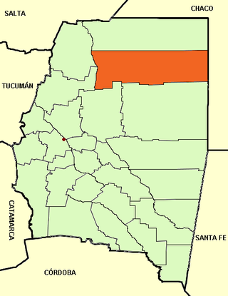
Alberdi Department is a department of Santiago del Estero Province, Argentina in the region of the Chaco Santiagueño. It is bordered on the north by Copo Department, on the east by Chaco Province, on the south by Moreno Department and Figueroa Department, and on the west by the Salado River which separates it from the Jiménez Department and Pellegrini Department. Its head town is Campo Gallo.

Paraje was a populated place along the east bank of the Rio Grande, in Socorro County, New Mexico, United States, now a ghost town. It is located north northeast of the Fra Cristobal Range.

<span class="mw-page-title-main">Ocampo Railway</span> Railway line in Argentina

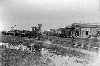
The Ocampo Railway, also called the first Chaco Railway and later La Forestal Railway, was the first railway of Villa Ocampo, of the North of Santa Fe and of the entire Gran Chaco Territory. It had a metric gauge (1000 mm) and was inaugurated on July 26, 1884. It was established by local settler Manuel Ocampo Samanés, who had also founded the city of Villa Ocampo in 1878.

References

27°40′S60°56′W / 27.667°S 60.933°W / -27.667; -60.933