Corregidor Island Lighthouse

Last updated
Corregidor Island lighthouse
Corregidor Lighthouse in 1893.jpg
Corregidor Lighthouse in 1893
Corregidor Island Lighthouse
Location Corregidor, Cavite, Philippines OOjs UI icon edit-ltr-progressive.svg
Coordinates 14°22′48″N120°34′37″E / 14.38011°N 120.57683°E / 14.38011; 120.57683
Tower
Constructed1853  OOjs UI icon edit-ltr-progressive.svg
Constructionstone tower
Height18 m (59 ft), 42 ft (13 m)  OOjs UI icon edit-ltr-progressive.svg
Shapecylindrical tower with double balcony and lantern
Markingswhite tower and lantern
gray tower (1903)
white tower (1920)
Light
First lit1853  OOjs UI icon edit-ltr-progressive.svg
Deactivated1942  OOjs UI icon edit-ltr-progressive.svg
Focal height195 m (640 ft), 630 ft (190 m)  OOjs UI icon edit-ltr-progressive.svg
Range1853: 20 miles (32 km)
1897: 33 miles (53 km) [1]
Characteristic Fl W 10s or 20s. (1853)
Al WR 10s.(1897)
1950 lighthouse [2] [1] [3] [4] OOjs UI icon edit-ltr-progressive.svg
Corregidor Island LIghthouse.jpg
Height48 ft (15 m)  OOjs UI icon edit-ltr-progressive.svg
First lit1950  OOjs UI icon edit-ltr-progressive.svg
Focal height633 ft (193 m)  OOjs UI icon edit-ltr-progressive.svg
Lenssecond order Fresnel lens  OOjs UI icon edit-ltr-progressive.svg
Characteristic Fl(3) W 20s  OOjs UI icon edit-ltr-progressive.svg

The first Corregidor Island Lighthouse was a historic lighthouse located on the island of Corregidor, in the province of Cavite, Philippines. The light station was one of the most important lights in the archipelago. It was established in 1853 to guide ships to the entrance of Manila Bay on their way to the port of Manila, the most important trading center in the country. This light occupies the converging point of two lines of approach for vessels from the China Sea which steer for the entrance of Manila Bay. Vessels from Hong Kong and the ports of China to the northwest first sight the Capones Island light off the southwest coast of Zambales. Vessels from ports of Indo-China first sight the Corregidor lights in the center. Vessels from Singapore, Indonesia, India, and all the ports of the Philippine Islands, to the south, first sight the Cabra Island light. All lines converge on Corregidor light at the bay entrance. [5]

Contents

Description

Corregidor, together with Caballo Island, divide the entrance of the bay into the North Channel and South Channel, also known as Boca Chica and Boca Grande, respectively in the Spanish era. The passage between the two islands is only 1/4 mile and is dangerous for large vessels.

The lighthouse was located on the highest point of the island (later known as the Topside) with an effective height of 639 feet (195 m) above sea level or 42-ft high from the base of the light tower. The total height of the tower measured 60.0 feet (18.3 m) from the base to the top of the wind vane. [1] The light was obscured when well into the steep north side of the island.

The cylindrical tower was originally colored gray with octagonal keeper's dwelling surrounding the base. The roof of the base also doubles as rain collector for the cisterns next to the lighthouse, which provide water not for only the station but supplements the need of the island.

History

Spanish Colonial Era

The two light stations, Corregidor and Caballo, were the second oldest lighthouses established in the country after the lighthouse at the mouth of the Pasig River. [6]

The establishment of a lighthouse station on the island of Corregidor was recommended in the year 1835 during the administration of Governor Pascual Enrile y Alcedo. Its construction was not authorized, however, until 1846 with the passing of Royal Order of April 14 by the Spanish Government. [7] The lighthouse was not completed until 1853 – eighteen years after the recommendation of its construction had been made. [8]

On January 18, 1853, notice to mariners were released announcing the start of service on February 1, 1853, for the second-order light on Corregidor, together with the fourth-order light on Caballo Island. Both lighthouses were equipped with lighting apparatus from Henry Lepaute of Paris. The white light on the summit of Corregidor revolved once every ten or twenty seconds, and visible in clear weather from a distance of 20 miles. Later, a fixed white light was also shown from the white tower on the West Mole Head, at the entrance to the bay on the north side of the island.

In 1897, the aging lighting apparatus was replaced by a provisional light of the same character, but of less power, before the installation of a new permanent light that was exhibited on August 1, 1897. The new apparatus flashed white and red light, showing white and red flashes alternately every ten seconds, separated by total eclipses, and is visible 36 miles in clear weather. [1]

The lighthouse in 1899 during the Philippine-American War Corregidor Island in 1899.jpg
The lighthouse in 1899 during the Philippine–American War

American Colonial Period

When the Americans took control of the country, the newly established Bureau of Coast Guard and Coast Guard made a complete tour of the country, inspecting all lighthouses and stations in the archipelago in 1902. All the lighthouses were found urgently needing repairs to preserve their good condition, to make the stations efficient and habitable. In Corregidor, repairs were done to rehabilitate the dwellings and tower, and a bamboo fence was erected. [9]

The main construction works in 1903 were renovating the old buildings, and the construction of new quarters for the light station. A school of apprentices was established in Manila the previous year to train competent lighthouse keepers, using Corregidor lighthouse as a training station. Three frame buildings for quarters and kitchens were erected. [9] [10]

The year after, a small party was sent to this station to make more minor repairs to doors, windows, and drains, part of the appropriation from Acts 807 and 1049. [11]

In 1905, the bamboo fence at Corregidor light station being found in bad condition and was replaced with posts and boards. The system of gutters was changed to increase the water supply. A latrine was built, new floors were put in the keepers' dwellings as they were damaged by termites. [12]

With funds from the approval of Act No. 1225 for lighthouse maintenance, some were applied to the purchase of the necessary parts from Paris to convert the polygonal lantern at Corregidor into a cylindrical lantern to diminish the interval between flashes from ten to five seconds and to replace the wick burner with the incandescent system. [12]

In 1908, the Corregidor Island became a U.S. military installation and was designated as Fort Mills as part of the harbor defense of Manila Bay. The Americans started fortifying the island as main naval defense fort for the bay in case of war.

World War II

On December 8, 1941, the day the Japanese invaded the Philippines, the lighthouses on Corregidor, Caballo, and Monja Island were extinguished as agreed by the Navy and the Harbor Defense Commander. [13]

From December 16, Corregidor lighthouse was used by the Navy to facilitate the entrance of submarines carrying supplies and ammunition for the troops on the island as authorized by General Douglas MacArthur. The light was shown the first ten minutes of each one-half hour on a secret schedule furnished by the Navy for each entry. Only white light was shown and on a fixed specified azimuth. As the submarine passes through the controlled mine fields, the Inshore Patrol coordinating with the Harbor Defense put the mines on "safe" and the marking buoys were illuminated by searchlights. [13]

The first damage to the lighthouse happened on January 14 around noon when two flights of bombers, nine each, bombed mostly the Topside. The lighthouse and surrounding buildings were damaged but the light was still operable using a kerosene lamp. [13]

During the fight for liberation from the Japanese, the island was heavily bombed leaving every building in the island in ruins. The lighthouse did not survive the bombardment.

The lighthouse today

Around the 1950s, the lighthouse was rebuilt using some of the original stones from the ruins but using a different design. The base now houses a souvenir shop for tourists of the historical island.

The lantern was replaced in the 1990s with a solar-powered light as part of the Maritime Safety Improvement Project by the Philippine Coast Guard. [14]

See also

Related Research Articles

<span class="mw-page-title-main">Caballo Island</span> Island in Philippines

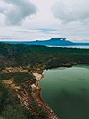
Caballo Island is a bluff, rocky island located at the entrance to Manila Bay in the Philippines. It is about 1.2 km (0.75 mi) long with the highest elevation at 381 feet high. Caballo, along with the larger Corregidor, divides the entrance to the bay into two broad and deep channels, known as the North and South Channel.

<span class="mw-page-title-main">Corregidor</span> Island in the Philippines

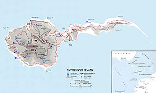
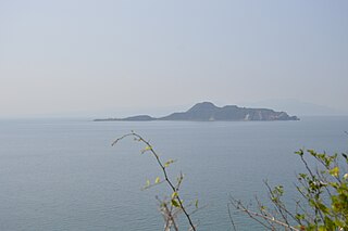
Corregidor is an island located at the entrance of Manila Bay in the southwestern part of Luzon in the Philippines, and is considered part of the Province of Cavite. Due to this location, Corregidor has historically been fortified with coastal artillery batteries to defend the entrance of Manila Bay and Manila itself from attacks by enemy warships. Located 48 kilometres (30 mi) inland, Manila is the nation's largest city and has been the most important seaport in the Philippines for centuries, from the colonial rule of Spain, Japan, and the United States, up through the establishment of the Third Philippine Republic in 1946.

<span class="mw-page-title-main">Harbor Defenses of Manila and Subic Bays</span> World War II fortifications

The Harbor Defenses of Manila and Subic Bays were a United States Army Coast Artillery Corps harbor defense command, part of the Philippine Department of the United States Army from circa 1910 through early World War II. The command primarily consisted of four forts on islands at the entrance to Manila Bay and one fort on an island in Subic Bay.

<span class="mw-page-title-main">Battle of Manila Bay</span> 1898 battle during the Spanish–American War

The Battle of Manila Bay, also known as the Battle of Cavite, took place on 1 May 1898, during the Spanish–American War. The American Asiatic Squadron under Commodore George Dewey engaged and destroyed the Spanish Pacific Squadron under Contraalmirante Patricio Montojo. The battle took place in Manila Bay in the Philippines, and was the first major engagement of the Spanish–American War. The battle was one of the most decisive naval battles in history and marked the end of the Spanish colonial period in Philippine history.

<span class="mw-page-title-main">Fort Drum (Philippines)</span> Abandoned sea fort in Manila Bay

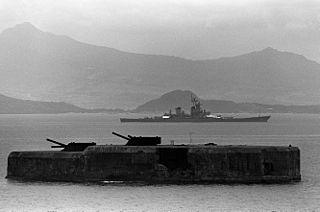
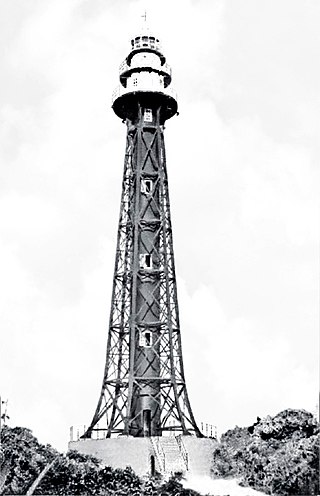
Fort Drum, also known as El Fraile Island, is a heavily fortified island situated at the mouth of Manila Bay in the Philippines, due south of Corregidor Island. Nicknamed a "concrete battleship", the reinforced concrete sea fort, shaped like a battleship, was built by the United States in 1909 as one of the harbor defenses at the wider South Channel entrance to the Bay during the American colonial period.

USC&GS <i>Marinduque</i>

USC&GS Marinduque was a steamer, owned by the Philippine Insular Government, that served exclusively in the Philippines. The ship was purchased by the Philippine Bureau of Coast Guard and Transportation to support both government logistical and administrative travel needs as well as the usual functions of a coast guard vessel. The vessel was transferred to the United States Coast and Geodetic Survey serving as a survey ship from 1905 to 1932. Marinduque and Romblon were sister ships, both built in Japan.

USC&GSS <i>Research</i>

USC&GSS Research was a survey vessel owned by the Philippine Insular Government to be the first vessel operated by the United States Coast and Geodetic Survey in the Philippines from 1901 until 1918.

USC&GSS <i>Pathfinder</i>

The first USC&GSS Pathfinder, also noted in some NOAA histories as "old Pathfinder", was a United States Coast and Geodetic Survey ship in service from 1899 to 1941, when she was beached in sinking condition on January 30, 1942, after 40 years service in the Philippines.

<span class="mw-page-title-main">Cape Bojeador Lighthouse</span> Historic lighthouse in Ilocos Norte, Philippines

Cape Bojeador Lighthouse, also known as Burgos Lighthouse, is a cultural heritage structure in Burgos, Ilocos Norte, that was established during the Spanish colonial period in the Philippines. The lighthouse was first lit on March 30, 1892, and is set high on Vigia de Nagpartian Hill overlooking the scenic Cape Bojeador where early galleons used to sail by. After over 100 years, it still functions and serves ships that enter the Philippine archipelago from the north and guide them safely away from the rocky coast of the town.

<span class="mw-page-title-main">Pasig River Lighthouse</span> Historic lighthouse in Manila, Philippines

The Pasig River Light was the first light station in the Philippines when it was established in 1642. The first lighthouse tower in the country was erected in the station and first lit in 1846. It was then located on the north jetty at the mouth of the Pasig River in San Nicolas, Manila, marking the entrance of the river for vessels cruising Manila Bay, looking to dock on the inland Port of Manila that was then located along the banks of the Pasig River in Binondo and Intramuros.

<span class="mw-page-title-main">Maniguin Island Lighthouse</span> Historic lighthouse in Antique, Philippines

The Maniguin Island Lighthouse is a lighthouse that marks the Cuyo East Passage, a main shipping route south into the Sulu Sea. The island, also known as Maningning Island or Hammerhead Island, is located 42.6 kilometres (26.5 mi) off of the coast of Culasi, Antique in the Philippines. It has a narrow ridge 33.5 metres (110 ft) high across its southern end, and the remainder of the island is low and wooded, and not more than 4.5 metres (15 ft) high. It is fringed with coral reefs with deep water at their edges. The round cylindrical concrete tower with a gallery on top is located near the southeastern point of the island.

Batag Island Lighthouse is a historic lighthouse on Batag Island off the coast of the town of Laoang in the province of Northern Samar in the Philippines. The light marks the northeastern point of Samar Island and led international ships to the entrance of the San Bernardino Strait marked by the San Bernardino Light. One of the most traveled waterways in the archipelago, together with the Capul Island Light, these stations are invaluable to vessels coming from the Pacific Ocean and entering the country through the San Bernardino Strait on its way to Manila or any other ports of the Philippines.

<span class="mw-page-title-main">Cabra Island Lighthouse</span> Historic lighthouse in Occidental Mindoro, Philippines

The Cabra Island Lighthouse is a historic lighthouse built on Cabra Island, the north-westernmost of the Lubang group of islands in Occidental Mindoro, Philippines. International vessels entering the Philippines from South China Sea were welcomed by the Cabra Light and directed either towards Manila Bay or the center of the archipelago through Verde Island Passage, one of busiest sea routes of the Philippines.

<span class="mw-page-title-main">Apo Reef Lighthouse</span> Historic lighthouse in Occidental Mindoro, Philippines

The Apo Reef Light was a historic lighthouse built on Bajo Apo Island in Apo Reef Natural Park. The park is located in the middle of Mindoro Strait, west of the province of Occidental Mindoro, in the Philippines. The station was established to warn ships of the dangerous shallow reefs in that part of the strait.

Bagatao Island Lighthouse is a historic lighthouse located on Bagatao Island on the eastern side of the entrance to Sorsogon Bay, in the province of Sorsogon in the Philippines. The 29-foot (8.8 m) white cylindrical iron tower is situated on the rocky headland that forms the southern point in the western end of the Island, giving the total light elevation of {convert|135|ft}}. The light not only marks the entrance to the bay, but also assists ships in navigating the bend around Ticao Island of Masbate province as they head to San Bernardino Strait and exit to the Pacific Ocean.

Bugui Point Lighthouse is a historic lighthouse located on Bugui Point in the town of Aroroy, in the northern tip of Masbate Island, province of Masbate, in the Philippines. It lights the entrance to the channel between Burias Island and Masbate Island and the channel between Burias and Ticao Islands leading to San Bernardino Strait.

<span class="mw-page-title-main">Capones Island Lighthouse</span> Historic lighthouse in Zambales, Philippines

Capones Island Lighthouse is a historic lighthouse located in Capones Island off the coast of Barangay Pundaquit, San Antonio, in the province of Zambales, in the Philippines. The light guides international vessels coming from the north to northwest towards Subic Bay or to Corregidor Island Lighthouse at the entrance of Manila Bay. It had first-order lenses when it was first lit on August 1, 1890.

<span class="mw-page-title-main">Cape Moreton Light</span> Lighthouse in Queensland, Australia

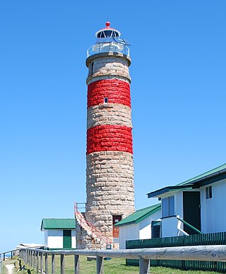
Cape Moreton Light, also listed as North Point Range Rear Light, is a heritage-listed active lighthouse located on Cape Moreton, a rocky headland located at the north eastern tip of Moreton Island, a large sand island on the eastern side of Moreton Bay, on the coast of South East Queensland, Australia. It marks the northern entrance to Moreton Bay and Brisbane and also serves as the rear light for the North Point Range. With its two distinctive red bands, it also serves as a daymark. It is the oldest lighthouse in Queensland, and the only one to be built by the New South Wales Government before the separation of Queensland, which took place in 1859. It is also the only lighthouse in Queensland to be built of stone.

<span class="mw-page-title-main">Poro Point</span>

Poro Point, also known historically as San Fernando Point, is a headland and peninsula located in the city of San Fernando, La Union, on the island of Luzon in the Philippines. It projects northwesterly about 3.2 kilometres (2.0 mi) into the South China Sea. It was named after its location within barangay Poro and is the site of Poro Point Freeport Zone, a special economic zone established since 1993.

References

  1. 1 2 3 4 U.S. War Department, "Military Notes on the Philippines", p.48-49. Washington Government Printing Office, 1898.
  2. List of Lights, Pub. 112: Western Pacific and Indian Oceans Including the Persian Gulf and Red Sea (PDF). List of Lights . United States National Geospatial-Intelligence Agency. 2009. p. 184.
  3. World List of Lights Philippines”, Amateur Radio Lighthouse Society. Retrieved on 2010-07-04.
  4. Rowlett, Russ. "Lighthouses of the Philippines: Southwest Luzon". The Lighthouse Directory. University of North Carolina at Chapel Hill . Retrieved 2016-03-12.
  5. United States Bureau of Insular Affairs. "A Pronouncing Gazetteer and Geographical Dictionary of the Philippine Islands, United States of America", p. 186. Washington Government Printing Office, 1902.
  6. "Guia Oficial de Filipinas, 1892", p.107. Tipo-Litografias de Choere y Comp., Escolta num. 33, 1892.
  7. San Pedro, D. Joaquin Rodriguez, "Legislacion Ultramarina, Tomo Cuatro", p.532. Establecimiento Tipografico de Jose Fernandez Cancela, Madrid, 1865.
  8. Vargas, Jose B. (1934). "A Brief Outline of Aids to Navigation in the Philippine Archipelago". Port of Manila Yearbook 1934, p.21.
  9. 1 2 U.S. War Department. "Report of the Philippine Commission, 1902 Part I", pp. 243–245. Washington Government Printing Office.
  10. U.S. War Department. "Fourth Annual Report of the Philippine Commission, 1903, Part 1", pp.202–203. Washington Government Printing Office.
  11. Bureau of Insular Affairs, War Department. "Fifth Annual Report of the Philippine Commission, 1904, Part 3 of 3"] , p.152. Washington Government Printing Office, 1905.
  12. 1 2 Bureau of Insular Affairs, War Department. "Sixth Annual Report of the Philippine Commission, 1905, Part 3 of 4"], pp.287–289. Washington Government Printing Office, 1906.
  13. 1 2 3 "The Moore Report-The Campaign". Corregidor.org. Retrieved on 2011-05-31.
  14. "Project Summary and Comparison of Original Plan and Actual" Archived 2012-03-22 at the Wayback Machine . Japan International Cooperation Agency (JICA). Retrieved on 2011-06-03.