Cotingo River

Last updated
Cotingo River
Rio Cotingo 2.JPG
Cotingo River, São Marcos indigenous reserve
Relief Map of Brazil.jpg
Red pog.svg
Native nameRio Cotingo (Portuguese)
Location
Country Brazil
Physical characteristics
Source 
  location Roraima state
Mouth  
  location
Surumu River, Pacaraima, Roraima
  coordinates
3°54′42″N60°30′04″W / 3.911686°N 60.501107°W / 3.911686; -60.501107 Coordinates: 3°54′42″N60°30′04″W / 3.911686°N 60.501107°W / 3.911686; -60.501107

The Cotingo River (Portuguese : Rio Cotingo) is a river of Roraima state in northern Brazil, a tributary of the Surumu River. It flows through the Raposa Serra do Sol indigenous territory. For many years there has been discussion over building a major hydroelectric power project on the river.

Contents

River basin

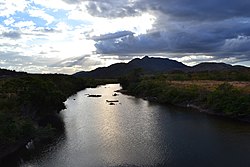
The Cotingo River has its headwaters at the foot of Mount Roraima in the Guayana Highlands region. The upper part of the Cotingo River basin is contained in the 116,748 hectares (288,490 acres) Monte Roraima National Park, a protected area created in 1989 that is fully contained in the Raposa Serra do Sol indigenous territory. [1]

The river runs for about 210 kilometres (130 mi) to its confluence with the Surumu River, of which is the main tributary.

It contains continuous stretches of rapids and waterfalls. [1] The savanna region of the river basin has an equatorial climate with tropical monsoon rainfall.

Conservation

It is home to the Sun parakeet (Aratinga solstitialis), Rio Branco antbird (Cercomacra carbonaria), Finsch's euphonia (Euphonia finschi), Bearded tachuri (Polystictus pectoralis) and Hoary-throated spinetail (Synallaxis kollari). [2]

The river basin has high potential for mining, agriculture, ranching, and ecotourism, and as a result there is tension between the strong Indian population and the ranchers and settlers. [3]

Hydroelectric project

Plans have been made for a hydro-electric project on the river. [3] The first studies of the hydroelectric project were made in the 1970s. The proposed hydroelectric project would involve building five dams along the length of the river.

In 2006 the federal senate approved a legislative decree aimed to authorise the work, which would be undertaken in an indigenous area and would affect the Ingarikó, Makuxi, Patamona, Taurepang and Wapixana people. [4]

Nothing had been done by 2011 and the priority in Roraima state had turned to construction of the Bem Querer dam on the Branco River. [5]

The planned dam would have potential capacity of 136 MW and would flood an area of 37 square kilometres (14 sq mi). It would cost US$140 million. [4] The first community to be flooded would be Tamanduá in the Serra region. [6]

Wind power and solar power would be sufficient to meet the Raposa Serra do Sol's energy needs, but the project would be able to deliver power to the whole state. The indigenous people were concerned about the environmental impact and also the influx of non-indigenous people that would be expected. [6]

See also

Related Research Articles

<span class="mw-page-title-main">Raposa Serra do Sol</span> Indigenous territory in Roraima, Brazil

Terra indígena Raposa/Serra do Sol is an indigenous territory in Brazil, intended to be home to the Macuxi people. It is located in the northern half of the Brazilian state of Roraima and is the largest in that country and one of the world's largest, with an area of 1,743,089 hectares and a perimeter of about 1,000 kilometres (620 mi).

<span class="mw-page-title-main">Itaituba</span> City in North, Brazil

Itaituba is a city and municipality located in the state of Pará, Brazil, and one of the most important socioeconomic centers in the western region of the State.

<span class="mw-page-title-main">Uiramutã</span> Municipality in North, Brazil

Uiramutã is a municipality located in the northeast of the state of Roraima in Brazil. Its population is 10,789 and its area is 8,066 km2. It is the northernmost municipality of Brazil, with Monte Caburaí being the northernmost point. West of this mountain, there is also the Monte Roraima, the tallest mountain in Roraima and in Guyana, located in the triple frontier of Brazil, Guyana and Venezuela. Still, Uiramutã holds the title of the northernmost urban seat of a municipality in Brazil. Its counterparts in the South, West and East are respectively Chuí, state of Rio Grande do Sul; Mâncio Lima, Acre; and João Pessoa, Paraíba.

<span class="mw-page-title-main">Balbina Dam</span> Dam in Amazonas, Brazil

The Balbina Dam is a hydroelectric dam and power station on the Uatumã River in the Amazon Rainforest, Brazil. The location is under the municipality of Presidente Figueiredo jurisdiction, in the state of Amazonas.

<span class="mw-page-title-main">Jamanxim River</span> River in Brazil

The Jamanxim River is a river of Pará state in north-central Brazil. Originating in the Serra do Cachimbo, it is a tributary of the Tapajós, into which it flows a few kilometers upstream from Itaituba.

The Panari River is a river of Roraima state in northern Brazil. It is a tributary of the Cotingo River.

<span class="mw-page-title-main">Xingó Dam</span> Dam in Near Piranhas on border of Alagoas and Sergipe, Brazil

The Xingó Dam is a concrete face rock-fill dam on the São Francisco River on the border of Alagoas and Sergipe, near Piranhas, Brazil. The dam was built for navigation, water supply and hydroelectric power generation as it supports a 3,162 megawatts (4,240,000 hp) power station. It was constructed between 1987 and 1994 and the last of its generators was commissioned in 1997. In Portuguese, the dam is called the Usina Hidrelétrica de Xingó.

<span class="mw-page-title-main">Juruena National Park</span> National park in Brazil

Juruena National Park, declared in 2006, is the third largest national park of Brazil. It is located along the Juruena River, in the north of Mato Grosso state and the south of Amazonas state. It forms part of a corridor of protected areas that is meant to contain agricultural expansion into the Amazon rainforest.

<span class="mw-page-title-main">Samuel Hydroelectric Dam</span> Dam in Rondônia

The Samuel Hydroelectric Dam is a 216 MW hydroelectric dam near Porto Velho, Rondônia, Brazil. The project was controversial since it had a major environmental impact and during operations released more greenhouse gases than a comparable oil-fuelled plant.

<span class="mw-page-title-main">Mapinguari National Park</span> National Park in Rondônia and Amazonas, Brazil

Mapinguari National Park is a national park in the states of Rondônia and Amazonas, Brazil. It covers a large area of Amazon rainforest. The boundaries have been adjusted several times.

<span class="mw-page-title-main">Mount Roraima National Park</span>

Mount Roraima National Park is a national park in the state of Roraima, northern Brazil.

The Lago de Santa Isabel Environmental Protection Area is an environmental protection area in the state of Tocantins, Brazil. It was created to protect the shores of the reservoir of a planned hydroelectric dam, which has not been given an environmental license. Vegetation is in the Amazon biome.

<span class="mw-page-title-main">Jatobá Hydroelectric Power Plant</span> Dam in Itaituba, Pará

The Jatobá Hydroelectric Power Plant is a planned hydroelectric power plant and dam on the Tapajós river in the state of Pará, Brazil. As of 2017 the project was suspended.

The Chacorão Dam is a proposed dam on the Tapajós river in the state of Pará, Brazil. It would flood a section of rapids in the river, making them navigable by barges carrying soybeans to ports on the Amazon River. The dam would include locks for the barges and a hydroelectric power plant. It is controversial since it would flood a large area of an indigenous territory.

<span class="mw-page-title-main">Munduruku Indigenous Territory</span> Indigenous territory in Pará, Brazil

The Mundurucu Indigenous Territory is an indigenous territory in the state of Pará, Brazil. It is occupied by the Apiacá and Munduruku people. A proposed dam on the Tapajós river is on hold since it would flood part of the territory, and the constitution does not allow projects that would force relocation of indigenous people.

The Cachoeira do Cai Dam is a planned hydroelectric dam on the Jamanxim River in the state of Pará, Brazil, with a capacity of 802 megawatts (1,075,000 hp).

The Cachoeira dos Patos Dam is a proposed hydroelectric dam on the Jamanxim River in the state of Pará, Brazil. Work has been delayed due to concern about environmental impact and lack of consultation with affected indigenous people.

The Jardim do Ouro Dam is a proposed hydroelectric dam on the Jamanxim River in the state of Pará, Brazil. The dam would have a 42,600 hectares reservoir and capacity of 227 megawatts (304,000 hp). It has not been studied on detail due to relatively low return on investment compared to other projects in the region.

The Jamanxim Dam is a proposed hydroelectric dam on the Jamanxim River in the state of Pará, Brazil.

<span class="mw-page-title-main">Tapajós hydroelectric complex</span> Proposed dams in Pará, Brazil

The Tapajós hydroelectric complex is a proposed complex of hydroelectric dams on the Tapajós and Jamanxim rivers in the state of Pará, Brazil. The Tapajós dams would contain locks, thus converting the river into a navigable waterway. A "platform" model is proposed under which all people and material would be moved by river or by helicopter, avoiding the need to build access roads and the consequent inflow of settlers and environmental damage. However, there have been protests against flooding of indigenous territory by the dams, and the largest dam seems unlikely to be approved.

References

  1. 1 2 Unidade de Conservação ... MMA.
  2. Savanas do Rio Cotingo IBA – Global Species.
  3. 1 2 Furley 2002, p. 202.
  4. 1 2 Cotingo Perfil da usina – Barragens na Amazonia.
  5. Luis Cláudio de Jesus Silva & Carlos Vicente Joaquim 2011, p. 154.
  6. 1 2 Luciano Nascimento 2013.

Sources