
In the United Kingdom, a deserted medieval village (DMV) is a former settlement which was abandoned during the Middle Ages, typically leaving no trace apart from earthworks or cropmarks. If there are fewer than three inhabited houses the convention is to regard the site as deserted; if there are more than three houses, it is regarded as a shrunken medieval village. There are estimated to be more than 3,000 DMVs in England alone.

Barby is a village and civil parish about 5 miles (8 km) north of Daventry in Northamptonshire, England. The 2011 Census recorded the parish population as 2,336. Barby is located right off the M45 motorway a short spur from the M1 motorway to the A45 Trunk Road.

Staverton is a village and civil parish in the south-west of Northamptonshire, England. It is 2.3 miles west of Daventry, 7.9 miles east of Southam and 15.3 miles east of Leamington Spa. It straddles the A425 road from Daventry to Leamington. The Jurassic Way long distance footpath between Banbury and Stamford passes through the village.
Ravensthorpe is a village and civil parish in West Northamptonshire in England. The village lies approximately midway between Northampton and Rugby. The M1 motorway is six miles west and the nearest railway station is at Long Buckby. At the time of the 2001 census, the parish's population was 656 people, including Coton but falling slightly to 646 at the 2011 census.

Dodford is a village in West Northamptonshire, England. Prior to local government changes in 2021 it was within the Weedon Ward of Daventry District. The village is just north of the A45 road 1½ miles west of Weedon. The population of the civil parish at the 2011 Census was 203. It is 3½ miles east of Daventry and ten miles west of Northampton. It is also close to junction 16 of the M1 motorway. The parish consists of some 1,384 acres and is bounded on the east by the A5 trunk road which is the old Roman road of Watling Street. Most of the village and parish sits astride the valley of an east-flowing stream which is a tributary of the River Nene.

Charwelton is a village and civil parish about 5 miles (8 km) south of Daventry in Northamptonshire, England. The 2011 Census recorded the parish's population as 220.
Archdeacon Newton is a hamlet and rural parish of several farms in the borough of Darlington and the ceremonial county of County Durham, in England. The population taken at the 2011 Census was less than 100. Details are maintained in the parish of Walworth. It is associated with an abandoned village site under pasture and farm buildings, and situated a short distance to the north-west of Darlington. The lost settlement was in existence by the early 15th century, and remained inhabited at least until the 1890s. There was a moated manor house at the southern end, part of which remains as the Old Hall, now a barn. At the north end of the site was the chapel, and in the middle were tofts and enclosures, with a ridge and furrow field and a trackway leading to the south-east. The site of the abandoned village is now a scheduled monument and the Old Hall is a listed building.
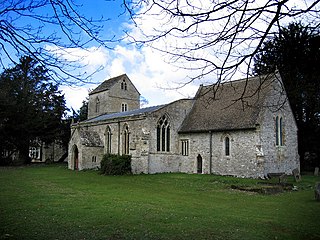
Wolfhampcote is an abandoned village and civil parish in the English counties of Warwickshire and Northamptonshire, which it straddles. The civil parish of Wolfhampcote in Rugby borough, includes the old village, plus the nearby village of Flecknoe, and the small hamlets of Sawbridge and Nethercote. In 2001, the parish had a population of 263, increasing to 284 in the 2011 Census. Flecknoe is the largest settlement in the parish.

West Farndon is a hamlet and deserted medieval village about 3⁄4 mile (1.2 km) southwest of Hinton, Northamptonshire, in the civil parish of Woodford cum Membris.

Alderton is a small English village and civil parish about 9 miles (14 km) south of Northampton, and 10 miles (16 km) north of Milton Keynes, along a road between the A5 and A508 main roads in the southwest and northeast respectively. The nearest large town is Towcester, about 3 miles (5 km) north. The village is famous for the remains of an English Heritage Scheduled Ancient Monument, a Norman Castle, known locally as "The Mount", which was the subject of an investigation by the Channel 4 programme Time Team.

Althorp is a lost village within the grounds of the Althorp estate in the English county of Northamptonshire. The village is recorded in the Domesday Book. In the 15th century, the manor was held by the Catesby family who were probably responsible for clearing the settlement, for by 1505, the records show that there were no tenants. In 1508, the parish, including the cleared settlement of Althorp, was sold to John Spencer of Wormleighton in Warwickshire. By 1577, the land in the parish had been divided into four large sheep pastures. Althorp remains a civil parish.

The village of Braunston Cleves or Fawcliff formerly stood north of the village of Braunston in the English county of Northamptonshire at its border with Warwickshire. It has long been a "lost village", having no standing buildings, but its position and the topography of its street and houses can be traced from the irregularities of the ground where it formerly stood. It was on the southwest slope of Cleve's Hill within Braunston parish: it appears to have been occupied in late Anglo-Saxon and early post-Conquest times. Nothing is known of why the village was deserted but it had certainly been destroyed by the 18th century.

The lost village of Braunstonbury lies in low ground south-west of the village of Braunston in the English county of Northamptonshire. Its site is on the eastern bank of the River Leam, which also marks the border between Northamptonshire and Warwickshire. Adjacent to the site on the west side of the river Leam is the site of the lost village of Wolfhampcote which straddled the county border of both counties.

The lost village of Canons Ashby is located in ground to the north of Canons Ashby House in the English county of Northamptonshire. Today there is still a small village around the house but this is located away from the original settlement, since the original settlement is now just field occupied by a herd of cows.
Ascebi is the name of the medieval village that is the lost settlement, Canons Ashby itself is currently not lost at all and people can easily find it on any map.

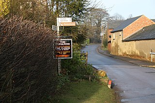
The lost village of Onley is in the parish of Barby in the English county of Northamptonshire. The site is bordered on the north by the M45 motorway. On the east are Onley and Rye Hill prisons, and on the south-west is the A45 road. The Oxford Canal and the disused trackbed of the Great Central Railway run close to the eastern boundary.
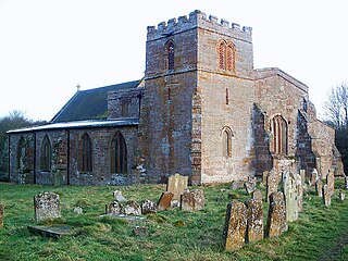
The lost village of Church Charwelton lies south-east of the village of Charwelton in the English county of Northamptonshire. Its site is on the north-east bank of the River Cherwell. The Jurassic Way long-distance footpath passes across the site.
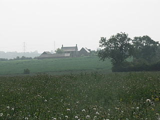
Glendon is a deserted village in the English county of Northamptonshire. Its location was on land to the east of Glendon Hall, now within the parish of Rushton. Neighbouring towns include Rothwell, Kettering, Rushton and Desborough.
The deserted village of Wythmail is located 4.5 miles south of Kettering in the English county of Northamptonshire. The village of Orlingbury is 1.1 miles to the east. Wythmail was part of the parish of Orlingbury.

Grimscote is a hamlet in the civil parish of Cold Higham, in the West Northamptonshire district of Northamptonshire, England. Grimscote is one of 4 settlements that make up Cold Higham parish. According to the 2011 UK census, the population in Grimscote in 2011 was 241. It is understood that the name Grimscote means "Grim's Cott", Grim being another name for Woden.
Radstone is a hamlet and civil parish in West Northamptonshire, about 2 miles (3 km) north of Brackley. The 2001 Census recorded a parish population of 54. At the 2011 Census the population of the hamlet remained less than 100 and was included in the civil parish of Whitfield.
