See also
| This disambiguation page lists articles associated with the title Cotton End. If an internal link led you here, you may wish to change the link to point directly to the intended article. |
Cotton End may refer to:
| This disambiguation page lists articles associated with the title Cotton End. If an internal link led you here, you may wish to change the link to point directly to the intended article. |

Bedfordshire is a county in the East of England. It is a ceremonial county and a historic county, covered by three unitary authorities: Bedford, Central Bedfordshire, and Luton.
The River Nene is a river in the east of England that rises from three sources in Northamptonshire. The tidal river is about 100 miles (160 km) long, about 3.7 miles (6.0 km) of which forms the border between Cambridgeshire and Norfolk. It is the tenth-longest river in the United Kingdom, and is navigable for 88 miles (142 km), from Northampton to The Wash.

The South Midlands is a notional area of England,, with no official status nor consensus definition. According to one definition, it is the southern portion of the East Midlands Region together with the northern portion of the South East England Region and the western portion of the East of England Region (Bedfordshire). Various organisations also use the name South Midlands to refer to an area that is specific to their own way of dividing up the country. One major usage is as a label for one of the areas identified by HM Government for urban development.

The A5199 road is the direct road from Northampton to Leicester in England. It was formerly part of the A50 trunk road that ran from Bedfordshire to Lancashire. For most of its length it is known as the Welford Road, except for small stretches near Welford where it is known as High Street and Northampton Road.

Haynes is a small village, civil parish and former manor, located in Bedfordshire, England, about seven miles (11 km) south of Bedford. It includes the small hamlet of Haynes Church End. It used to be known as Hawnes. North from Haynes is a hamlet named Silver End, then further up is Herrings Green, Cotton End and Shortstown.The name 'Haynes' is derived from an Old English word meaning "enclosures". It was mentioned in Domesday Book. There is a pub, "The Greyhound", a shop, a post office, a village hall and a Lower School.

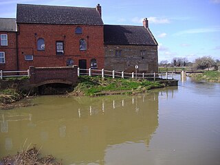
Turvey is a village and civil parish on the River Great Ouse in Bedfordshire, England, about 6 miles (9.7 km) west of Bedford. The village is on the A428 road between Bedford and Northampton, close to the border with Buckinghamshire. The 2011 Census recorded the parish's population as 1,225.
The 1741 English cricket season was the 45th cricket season since the earliest recorded eleven-aside match was played. Details have survived of nine significant matches, including the first known appearance of Slindon Cricket Club. The earliest known tie in an elevel-a-side match occurred.

The NN postcode area, also known as the Northampton postcode area, is a group of nineteen postcode districts in England, within eight post towns. These cover most of Northamptonshire, plus very small parts of Bedfordshire, Buckinghamshire, Oxfordshire and Warwickshire.

Far Cotton is a district in the town of Northampton, England and many years ago a village in its own right. The population is included in the Delapre and Briar Hill Ward of Northampton Borough Council.
Alexander "Alex" Rae born 2 February 1986 in Coventry, England is a rugby union player for Bedford Blues. He plays at lock. He previously played for the Northampton Saints, Saracens, London Wasps and Bedford Blues.
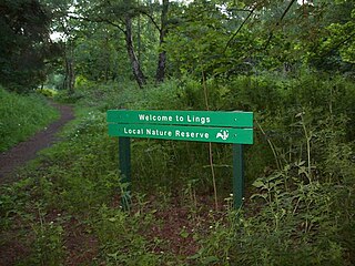
Lings Wood is a 20.1 hectare Local Nature Reserve in eastern Northampton. It is owned by Northampton Borough Council and managed by the Wildlife Trust for Bedfordshire, Cambridgeshire and Northamptonshire.
The Bedford–Northampton line was a branch of the Midland Railway which served stations in three counties: Northampton and Horton in Northamptonshire, Olney in Buckinghamshire and Turvey and Bedford in Bedfordshire, England. Opened in 1872, the intermediate stations closed to passengers in 1962, leaving a small section between Northampton and Piddington station to remain open until 1981 for the purposes of the Ministry of Defence establishment. The track remains down on another small section of the line between Northampton and Brackmills. The reopening of the line has been proposed by the Bedfordshire Railway & Transport Association.

Summer Leys is a local nature reserve at Wollaston in the Upper Nene Valley, in Northamptonshire, England. It is owned by the Wildlife Trust for Bedfordshire, Cambridgeshire and Northamptonshire.
Cotton End is a small district of the town of Northampton, England, about half a mile south of the town centre, north of the area known as Far Cotton and west of the road from South Bridge to Ransome Road known as Cotton End. The district population is included in the Delapre and Briar Hill Ward of Northampton Council.

Kingsthorpe Meadow is a 14.4 hectare Local Nature Reserve in Northampton. It is owned by Northampton Borough Council and managed by the Wildlife Trust for Bedfordshire, Cambridgeshire and Northamptonshire.

Ramsden Corner Plantation is a 3.2 hectare biological Site of Special Scientific Interest west of Northampton. It is managed by the Wildlife Trust for Bedfordshire, Cambridgeshire and Northamptonshire.

Storton's Pits is a 21.9 hectare Local Nature Reserve in Northampton. It is managed by the Wildlife Trust for Bedfordshire, Cambridgeshire and Northamptonshire.

Barnes Meadow is a 29.4 hectare Local Nature Reserve in Northampton. An area of 20 hectares is managed by the Wildlife Trust for Bedfordshire, Cambridgeshire and Northamptonshire.

Bradlaugh Fields is a 60 hectare open space in Northampton. The site is a former golf course. In 1987 it was proposed to build housing on the site, but after a campaign by local residents it was acquired by Northampton Borough Council and opened as a wildlife park in 1998. It was named after Charles Bradlaugh, a leading nineteenth century radical and atheist who was MP for Northampton. Three fields with a total area of 17.5 hectares are managed by the Wildlife Trust for Bedfordshire, Cambridgeshire and Northamptonshire as a nature reserve also called Bradlaugh Fields. Hills and Holes is at the southern end and two adjoining meadows, Scrub Field and Quarry Field, are at the northern end. Hills and Holes is an 8.3 hectare Local Nature Reserve (LNR) and Scrub Field is a 5.1 hectare LNR.
The East Midlands Rugby Football Union (EMRFU) is a governing body for rugby union in part of The Midlands, England. The union is the constituent body of the Rugby Football Union for the counties of Bedfordshire and Northamptonshire and the Huntingdonshire and Peterborough districts of Cambridgeshire and administers and organises rugby union clubs and competitions in those areas. It also administers the East Midlands county rugby representative teams.