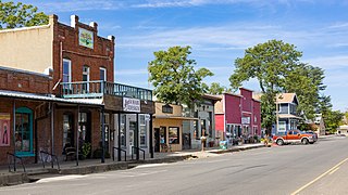
Cottonwood is a census-designated place (CDP) in Shasta County, California, United States. Its population is 6,268 as of the 2020 census, up from 3,316 from the 2010 census. Cottonwood was a stagecoach town where a settlement was established in 1849. The first Post Office was opened in 1852. Cottonwood is equidistant between Redding and Red Bluff, 15 miles (24 km) in either direction. It is 4 miles (6.4 km) south of Anderson.
California's 49th congressional district is a congressional district in the U.S. state of California. The district is represented by Mike Levin.

The San Jacinto River is a 42-mile-long (68 km) river in Riverside County, California. The river's headwaters are in Santa Rosa and San Jacinto Mountains National Monument. The lower portion of the 765-square-mile (1,980 km2) watershed is urban and agricultural land. As a partially endorheic watershed that is contiguous with other Great Basin watersheds, the western side of the San Jacinto Basin is a portion of the Great Basin Divide.

La Paloma Theatre is a historic Spanish Colonial Revival style movie theater in Encinitas, California.
San Dieguito Heritage Museum is a history museum in Encinitas, California, in the United States. Founded in 1988, the museum displays historical photographs and artifacts from Encinitas and the entire San Dieguito area.

Swami's is an area in San Diego County that contains Swami's Beach and other local attractions. The beach, also known as "Swami’s Reef'" and "Swamis", is an internationally known surfing spot, a point break located in Encinitas, San Diego County, California. Swami's was named after Swami Paramahansa Yogananda, because the grounds and hermitage of the Self-Realization Fellowship ashram, built in 1937, overlook this reef point. The name "Swami's" is also given to the sand beach that extends south from the point to the next beach access point, which is next to the San Elijo State Beach camping area; this more southerly surf spot often goes by the name "Pipes".

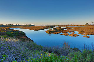
The Batiquitos Lagoon is a coastal wetland and estuary located between southern Carlsbad and Encinitas, in the North County region of San Diego County, California. The lagoon itself consists of 610 acres with a drainage basin of about 55,000 acres. Its primary freshwater tributaries being San Marcos Creek from the east and Encinitas Creek which flows north along Green Valley, entering the lagoon under El Camino Real and La Costa Avenue, respectively. It is one of the few remaining tidal wetlands on the southern California coast.
Cottonwood is a former settlement in Yolo County, California. It was located 2 miles (3.2 km) south of Madison, at an elevation of 164 feet. It still appears on maps as of 1917.

Moonlight State Beach is a state beach in Encinitas, California. It is located one fifth of one mile beyond the point where Encinitas Boulevard turns into B Street after it crosses Highway 101.
San Elijo Lagoon Ecological Reserve is one of the largest remaining coastal wetlands in San Diego County, California, United States.
Magic Carpet Ride is the official name of a 6-foot (1.8 m) high bronze sculpture (2007) of a surfer by Matthew Antichevich, an artist and sculpture instructor at Mt. San Jacinto College. The sculpture is mounted on a 6-foot high granite base with poetry inscription by Robert Nanninga, and is in Cardiff-by-the-Sea, Encinitas, California, United States. Locals have nicknamed Magic Carpet Ride as The Cardiff Kook, a pejorative name popularized by the local surfing community.
Swami’s State Marine Conservation Area (SMCA) is a marine protected area that extends offshore of Encinitas in San Diego County on California’s south coast. The SMCA covers 12.65 square miles. The SMCA protects marine life by limiting the removal of marine wildlife from within its borders.
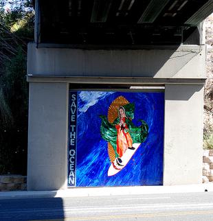
The Surfing Madonna is a 10 by 10 feet mosaic of the Virgen de Guadalupe created by artist Mark Patterson. It was covertly installed in Encinitas, California by Patterson and his friend Bob Nichols, who posed as construction workers during the installation. The city declared that the artwork was to be considered graffiti because of the illegality of its installation. Patterson came forward to accept responsibility for it, and was fined $500 and ordered to pay approximately $6,000 for the art's removal. It was removed in 90 minutes, and Patterson was allowed to keep the art.
Cottonwood River is one of the principal tributaries of the Neosho River in central Kansas of the United States.
Batiquitos Lagoon State Marine Conservation Area (SMCA) is a marine protected area in San Diego on California’s south coast. It is part of Batiquitos Lagoon, a coastal tidal wetland lying within the city limits of Carlsbad, California and adjacent to Encinitas, California. The SMCA covers 2000 miles. The SMCA protects marine life by limiting the removal of marine wildlife from within its borders.
San Elijo Lagoon SMCA (SMCA) is a marine protected area that protects the lagoon near Encinitas in San Diego County on California’s south coast. The SMCA covers 0.44 square miles (1.1 km2). The SMCA protects marine by limiting the removal of marine wildlife from within its borders. San Elijo SMCA prohibits take of all living marine resources except operation and maintenance, maintenance dredging, habitat restoration including sediment deposition, research and education, and maintenance of artificial structures inside the conservation area per any required federal, state and local permits, or activities pursuant to Section 632, or as otherwise authorized by the department.

The Temescal Mountains, also known as the Sierra Temescal, are one of the northernmost mountain ranges of the Peninsular Ranges in western Riverside County, in Southern California in the United States. They extend for approximately 25 mi (40 km) southeast of the Santa Ana River east of the Elsinore Fault Zone to the Temecula Basin and form the western edge of the Perris Block.
Rice Canyon Creek is a tributary creek or arroyo of Temescal Creek in Riverside County, California. Rice Canyon Creek has its source at the head of Rice Canyon at an elevation of 3440 feet in the Santa Ana Mountains at 33°41′54″N117°24′11″W east of the 4313 foot peak on the north south divide of the range. It is a wash that runs down from the canyon mouth 33°41′07″N117°27′08″W at 1631 feet to its mouth at its confluence with Temescal Creek near Alberhill, California at an elevation of 1220 feet. Rice Canyon Creek has a tributary, Bishop Canyon Creek which enters the wash on the left a little below the mouth of Rice Canyon at 33°42′05″N117°24′07″W.

Cottonwood Creek is a major stream and tributary of the Sacramento River in Northern California. About 68 miles (109 km) long measured to its uppermost tributaries, the creek drains a large rural area bounded by the crest of the Coast Ranges, traversing the northwestern Sacramento Valley before emptying into the Sacramento River near the town of Cottonwood. It defines the boundary of Shasta and Tehama counties for its entire length. Because Cottonwood Creek is the largest undammed tributary of the Sacramento River, it is known for its Chinook salmon and steelhead runs.
Gas Point is a former unincorporated community and former ghost town in Shasta County, California, on Cottonwood Creek. It was also known as Pinckney and Janesville and started as a 1849 California Gold Rush Mining town after gold was found at Reading's Bar.
