
Teller County is a county located in the U.S. state of Colorado. As of the 2020 census, the population was 24,710. The county seat is Cripple Creek, and the most populous city is Woodland Park.

El Paso County is a county located in the U.S. state of Colorado. The 2020 Census recorded its population as 730,395. The Census Bureau's 2020 result indicates it is the most populous county in Colorado, surpassing the City and County of Denver. The county seat is Colorado Springs, the second most populous city in Colorado. El Paso County is included in the Colorado Springs, Colorado, Metropolitan Statistical Area and is located in Colorado's 5th congressional district, except for the far eastern extremities, which are located in the 4th.
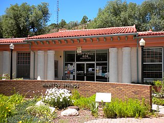
Manitou Springs is a home rule municipality located at the foot of Pikes Peak in western El Paso County, Colorado, United States. The town was founded for its natural mineral springs. The downtown area continues to be of interest to travelers, particularly in the summer, with many shops and restaurants, as well as a creekside city park. The main road through the center of town was one of the direct paths to the base of Pikes Peak. Barr Trail, which winds its way up Pikes Peak, is accessible from town. The subdivision Crystal Hills was added to the municipality in the 1960s.

The Lamar Boulevard Bridge is a historic arch bridge carrying Texas State Highway Loop 343 over Lady Bird Lake in downtown Austin, Texas, United States. The bridge features six open-spandrel concrete arches spanning 659 feet (201 m) and carries tens of thousands of vehicles daily across the lake. Completed in 1942, the Lamar Boulevard Bridge was the second permanent bridge to cross the Colorado River, and one of the last Art Deco-style open-spandrel concrete arch bridges built in Texas. The bridge was named an Austin Landmark in 1993 and added to the National Register of Historic Places in 1994.

Moore's Crossing Historic District is a community located in rural Travis County nine miles southeast of Austin, Texas near the Austin–Bergstrom International Airport.

The Black Squirrel Creek Bridge carries U.S. 24 over Black Squirrel Creek in El Paso County, Colorado. Prior to 2012, it was locally known as the "green bridge" or "old green bridge"—a historic single-span, Parker through truss bridge that was completed in 1935 and listed on the National Register of Historic Places in 2002. Because it no longer met highway safety standards, the bridge was dismantled and replaced by a newer span in 2012.

Pike's Stockade is a historic exploration campsite located near Sanford, Colorado. Set on the north bank of the Conejos River, it is where explorer Zebulon Pike raised the American flag on Spanish soil in 1807. The site, now managed by Historic Colorado, includes a reconstruction of a wooden stockade, built according to Pike's detailed description of the original. The site was declared a National Historic Landmark in 1961.

Cripple Creek Historic District is a historic district including Cripple Creek, Colorado, United States and is significant for its gold mining era history. It developed as a gold mining center beginning in 1890, with a number of buildings from that period surviving to this day. The mines in the area were among the most successful, producing millions of dollars of gold in the 1890s and supporting a population of 25,000 at its peak. It was declared a National Historic Landmark in 1961.

U.S. Route 64 is a U.S. highway running from Teec Nos Pos, Arizona east to Nags Head, North Carolina. In the U.S. state of Arkansas, the route runs 246.35 miles (396.46 km) from the Oklahoma border in Fort Smith east to the Tennessee border in Memphis. The route passes through several cities and towns, including Fort Smith, Clarksville, Russellville, Conway, Searcy, and West Memphis. US 64 runs parallel to Interstate 40 until Conway, when I-40 takes a more southerly route.

This is a list of the National Register of Historic Places listings in El Paso County, Colorado.

Chevelon Creek Bridge is a historic road bridge located about 12 miles (19 km) southeast of Winslow, in Navajo County, eastern Arizona, United States. It is a steel Warren Pony truss bridge over Chevelon Creek, built on the first permanent road connecting Holbrook, the seat of Navajo County, and Winslow. When built, the road was regionally important in northern Arizona as well as being a segment of an early national highway at the time automobile traffic was growing and national roads were first being formed. The bridge was listed on the National Register of Historic Places in 1983 for being a rare design in Arizona, part of an early transnational roadway, one of the first bridges built by Arizona after statehood in 1912, and being in nearly original condition.

Manitou Springs Bridges are historic bridges are located on Park and Canon Avenues over Fountain Creek in Manitou Springs, Colorado. The bridges are on the National Register of Historic Places.
Boulder Crescent Place Historic District is a historic area in Colorado Springs, Colorado along West Boulder and Cascade Avenue near the intersection of the two streets. It is a National Register of Historic Places listing and is on the Colorado State Register of Historic Properties.

Monument Valley Park is a historic, recreational park in Colorado Springs, Colorado through which Monument Creek flows. It is a National Register of Historic Places listing and is on the Colorado State Register of Historic Properties.

The Colorado Springs Pioneers Museum is located at 215 S. Tejon Street in Colorado Springs, Colorado. The granite building with a domed clock tower was the El Paso County Courthouse building from 1903 to 1973. The museum, which moved to this location in 1979, has fine arts, artifacts and archival collections that document the Pikes Peak region. The building is on the National Register of Historic Places, and was the 2nd property to be listed in El Paso County, after Pikes Peak.

The City Hall of Old Colorado City is a Richardsonian Romanesque Revival building from the Old Colorado City of Colorado Springs, Colorado. It was a city hall after it was built in 1888, but shortly after was used for other purposes including Hibbits Antique & Furniture Store. The building is on the National Register of Historic Places.
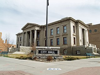
The Colorado Springs City Hall is a municipal building in Colorado Springs, Colorado. The building is on the National Register of Historic Places.

The DeGraff Building is a commercial building in Colorado Springs, Colorado. It is "one of the few remaining commercial buildings dating from the boom period following the Cripple Creek gold strike." The building is on the National Register of Historic Places.

The San Luis Bridge, also known as State Bridge or Bridge over Culebra Creek, is a historic open spandrel arch bridge that crosses Culebra Creek in San Luis, Colorado. It was built in 1911 as a road bridge, but now serves pedestrian traffic. It is listed on the National Register of Historic Places.

The Haggard Ford Swinging Bridge is a historic suspension bridge in Boone County, Arkansas. It is located adjacent to Cottonwood Road, about 8 miles (13 km) north of Harrison, and spans Bear Creek. It has cast-in-place concrete abutments, towers, and anchorages, and is supported by steel cables. A wooden deck, one travel lane in width, is suspended from steel hangers. The bridge is about 160 feet (49 m) long. The bridge was built 1938–41 with funding from the Works Progress Administration. Fill surrounding the abutments was washed away in 1945 and subsequently replaced. The bridge deck was replaced in 1977.


