Related Research Articles

Crafton is a hamlet in the civil parish of Mentmore, in Buckinghamshire, England.

Horton is a hamlet in the parish of Ivinghoe, in Buckinghamshire, England. It is in the civil parish of Slapton.

Llantwit Major is a town and community in Wales on the Bristol Channel coast. It is one of four towns in the Vale of Glamorgan, with the third largest population after Barry and Penarth, and ahead of Cowbridge. It is 4+1⁄2 miles (7.2 km) from Cowbridge, 9 miles (14 km) from Bridgend, 10 miles (16 km) from Barry, and 15 miles (24 km) from Cardiff. It had a population of 9,486 in 2011.

Cheadle Hulme is a suburb in the Metropolitan Borough of Stockport, Greater Manchester, England,. Historically in the county of Cheshire, Cheadle Hulme is 2.3 miles (3.7 km) south-west of Stockport and 7.5 miles (12.1 km) south-east of Manchester. It lies in the Ladybrook Valley, on the Cheshire Plain, and the drift consists mostly of boulder clay, sands and gravels. In 2011, it had a population of 26,479.

Middleton is a largely residential suburb of Leeds in West Yorkshire, England and historically a village in the West Riding of Yorkshire. It is situated on a hill 4 miles (6 km) south of Leeds city centre and 165 miles (266 km) north north-west of London.

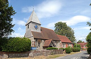
Hollingbourne is a village and civil parish in the borough of Maidstone in Kent, England. The parish is located on the southward slope of the North Downs to the east of the county town, Maidstone. The parish population is around 900 and has three conservation areas: Upper Street in the village centre and the outlying hamlets of Broad Street and Eyhorne Street.

Speke Hall is a wood-framed wattle-and-daub Tudor manor house in Speke, Liverpool, England. It is one of the finest surviving examples of its kind. It is owned by the National Trust and is a Grade I listed building.

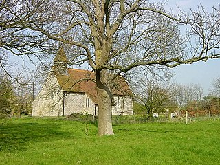
Wormshill, historically Wormsell, is a small village and civil parish within the Borough of Maidstone, Kent, England. The parish is approximately 7 miles (11 km) south of the Swale and 8 miles (13 km) east of Maidstone. The village of Frinsted lies 0.6 miles (1 km) to the east and Bicknor 1+1⁄2 miles (2.4 km) to the north-west; while Hollingbourne is 3 miles (5 km) to the south-west. The village lies on an exposed high point of the North Downs, within the Kent Downs Area of Outstanding Natural Beauty.
East Clandon is a village and civil parish in Surrey, England on the A246 between the towns of Guildford to the west and Leatherhead to the east. Neighbouring villages include West Clandon and West Horsley.
Hucking is a small hamlet and civil parish in the Maidstone District of Kent, England. It is located 4 miles (6.4 km) north-east of Maidstone and 5 miles (8.0 km) south-west of Sittingbourne. The parish is governed by a parish meeting.

Yelford is a hamlet in Hardwick-with-Yelford civil parish. It is about 3 miles (5 km) south of Witney.

Peckforton is a scattered settlement and civil parish in the unitary authority of Cheshire East and the ceremonial county of Cheshire, England. The settlement is located 6.5 miles (10.5 km) to the north east of Malpas and 7.5 miles (12.1 km) to the west of Nantwich. The civil parish covers 1,754 acres (710 ha), with an estimated total population of 150 in 2006. The area is predominantly agricultural. Nearby villages include Bulkeley to the south, Beeston to the north, Higher Burwardsley to the west, Spurstow to the east and Bunbury to the north east.
Farley Castle is an early 19th-century modern house situated at Farley Hill, Swallowfield, Berkshire.

The River Len is a river in Kent, England. It rises at a spring in Bluebell Woods to the southeast of the village centre of Lenham 0.6 miles (0.97 km) from the source of the River Great Stour; both rise on the Greensand Ridge. Its length is c10 miles (16 km). It enters the River Medway at Maidstone.

Thorndon Hall is a Georgian Palladian country house within Thorndon Park, Ingrave, Essex, England, approximately two miles south of Brentwood and 25 miles (40 km) from central London.
The River Medway and its tributaries and sub-tributaries have been used for more than 1,150 years as a source of power. There are over two hundred sites where the use of water power is known. Many different processes were performed by the use of water power:- corn milling, fulling, paper making, iron smelting, pumping water, making gunpowder, vegetable-oil extraction, and electricity generation. Today, there is just one watermill working for trade. Those that remain have mostly been converted. Such conversions include a garage, dwellings, restaurants, museums and a wedding venue. Some watermills are mere derelict shells, lower walls or lesser remains. Of the majority, there is nothing to be seen. A large number of tributaries feed into the River Medway. The tributaries that powered watermills will be described in the order that they feed in. The mills are described in order from source to mouth. Left bank and right bank are referred to as though the reader is facing downstream. This article deals with the watermills on the tributaries that feed in below Yalding.
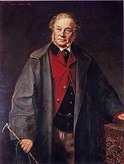
Rowland Eyles Egerton-Warburton was an English landowner and poet from the Egerton family in Cheshire. He was a devout Anglican in the high church tradition and a local benefactor. He paid for the restoration of his parish church and for the building of two new churches in villages on his estates. He also built cottages and farm buildings in the villages.
Gunby Hall is a country house in Gunby, near Spilsby, in Lincolnshire, England, reached by a half mile long private drive. The Estate comprises the 42-room Gunby Hall, listed Grade I, a clocktower, listed Grade II* and a carriage house and stable block which are listed Grade II. In 1944 the trustees of the Gunby Hall Estate, Lady Montgomery-Massingberd, Major Norman Leith-Hay-Clarke and Field Marshal Sir Archibald Montgomery-Massingberd, gave the house to the National Trust together with its contents and some 1,500 acres of land.
Iden Green is a small village, near Benenden, in the county of Kent. It belongs to the civil parish of Benenden and the Tunbridge Wells Borough District of Kent, in the South East of England.

Hitchin Priory in Hitchin in Hertfordshire is today a hotel built in about 1700 on the site of a Carmelite friary founded in 1317, which was closed in the Dissolution of the Monasteries during the reign of Henry VIII. Parts of the original priory are incorporated in the existing building, which has been a Grade I listed building on the Register of Historic England since 1951.
References
- ↑ "Hayl Hola" an appraisal of Hollingbourne Village published by Hollingbourne Parish Council in 1987. ISBN 0-905155-92-0
- ↑ "Hollingbourne - The History of a Kentish Parish" by Helen Allinson, Published by Synjon Books 2002 ISBN 0-904373-06-1