Council Headquarters, Newtown St Boswells

Last updated

Council Headquarters
Scottish Borders Council Headquarters at Newtown St Boswells (geograph 4367455).jpg
LocationBowden Road
Newtown St Boswells
Melrose
TD6 0SA
Coordinates 55°34′39″N2°40′25″W / 55.57752°N 2.67353°W / 55.57752; -2.67353
Architect Peter Womersley
Scottish Borders UK location map.svg
Red pog.svg
Council Headquarters
Location of Council Headquarters in Scottish Borders

The Council Headquarters is a municipal building in Newtown St Boswells, in the Scottish Borders council area in Scotland. It serves as the headquarters of Scottish Borders Council.

Roxburghshire County Council built the first office on the site in 1896. The site later became that council's headquarters and meeting place in 1930, known as the "County Offices". A substantial new building was added in 1968, which forms the main part of the current building. Following local government reform in 1975 the building became the headquarters of the Borders Regional Council and was renamed "Regional Headquarters". When local government was reorganised again in 1996 the building became the headquarters of Scottish Borders Council and was renamed "Council Headquarters".

History

The Roxburghshire Commissioners of Supply served as the main administrative body for Roxburghshire from 1667 until 1890, when the county council was created and took over most of the commissioners' functions. The commissioners met at Jedburgh, which had become the county town after the original county town at Roxburgh had been abandoned following the destruction of Roxburgh Castle in 1460 during the Anglo-Scottish Wars. In 1812 County Buildings was built at the junction of Market Place and Castlegate in Jedburgh, serving as both a sheriff court and meeting place for the commissioners. [1]

County Buildings, Castlegate, Jedburgh Jedburgh - Queen Victoria Golden Jubilee Fountain - geograph.org.uk - 2636186.jpg
County Buildings, Castlegate, Jedburgh

Roxburghshire County Council was created in 1890 under the Local Government (Scotland) Act 1889, which established elected county councils in Scotland. The council held its first meeting on 22 May 1890 at the County Buildings in Jedburgh. At that meeting the question of where the council should meet was debated, with some arguing that Newtown St Boswells would be a better location, as St Boswells railway station was a junction with direct services to all parts of the county, whereas Jedburgh railway station was on a minor branch line and harder to reach from much of the county, despite being more central. A vote was taken, with 21 in favour of meeting at Jedburgh and 12 in favour of Newtown St Boswells. Full council meetings were therefore held at the County Buildings in Jedburgh. [2]

Despite choosing to meet in Jedburgh, the council did recognise the advantages of Newtown St Boswells for those members of the council's staff who needed to travel around the county. In 1896 the council feued land from the Duke of Buccleuch on Bowden Road, opposite St Boswells station, and built a small building there called the County Rooms, containing rooms for the medical officer, sanitary inspector, and secretary, as well as a laboratory and a board room, which was used for committee meetings but not full council meetings. [3] [4]

In 1928 the Roxburghshire Education Authority, a separate body to the county council, built itself a headquarters immediately north of the County Rooms. [5]

The county council's functions were significantly expanded in May 1930 under the Local Government (Scotland) Act 1929. It took over a range of services previously provided by the town councils of the county's burghs, and also took over the functions of the education authority, which was abolished. Prior to the 1930 reforms the council had employed a solicitor from Kelso as a part-time clerk and an accountant from Jedburgh as a part-time treasurer. After the reforms the council needed to employ many more full-time staff. Having inherited the 1928 education authority building next to County Rooms, it decided to base its new staff there, renaming the building County Offices. [6] Full council meetings were still held at the County Buildings in Jedburgh, but with the council's staff and main offices being at Newtown St Boswells, the council decided in December 1930 by 26 votes to 15 to move its meeting place to the County Offices at Newtown St Boswells, enlarging an existing meeting room there to become a council chamber. Some councillors opposed the move, observing that the railway accessibility of Newtown St Boswells was less relevant given that 75% of the councillors had cars. However, the prevailing view was that as the council already owned offices at Newtown St Boswells, moving meetings there was the most cost efficient way of bringing the council's meeting place and main offices together. [7]

The council's name and coat of arms on the exterior of the service tower. A detail on the Scottish Borders Council Headquarters building - geograph.org.uk - 1753471.jpg
The council's name and coat of arms on the exterior of the service tower.

In 1960 the council decided it needed larger premises. A competition was held to design a new building, which was won by Peter Womersley. [8] The design is a brutalist building of grey shuttered concrete, comprising a four-storey square block of offices around a central courtyard with a prominent concrete service tower to one side. The new building was built between 1966 and 1968 on a site immediately north-east of the 1928 building, to which it was linked. [9]

The 1896 County Rooms were demolished to make way for a car park. The 1928 building remains in place, but subsequent extensions have almost completely hidden it from public viewpoints. [10]

Roxburghshire County Council was abolished in 1975, when local government in Scotland was reorganised into upper-tier regions and lower-tier districts. Roxburghshire became part of the Borders region. At district level most of Roxburghshire went to the Roxburgh district, but Newtown St Boswells became part of the Ettrick and Lauderdale district. [11] The Borders Regional Council took over the County Offices in Newtown St Boswells, renaming the building "Regional Headquarters". [12] Further local government reform in 1996 saw the region's four districts merge with the regional council to become a single tier authority. [13] The reconstituted council renamed the area "Scottish Borders" and renamed the offices in Newtown St Boswells to "Council Headquarters". [14] [15]

Related Research Articles

<span class="mw-page-title-main">Hawick</span> A town in the Borders of Scotland

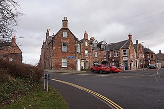
Hawick is a town in the Scottish Borders council area and historic county of Roxburghshire in the east Southern Uplands of Scotland. It is 10 miles (16.1 km) south-west of Jedburgh and 8.9 miles (14.3 km) south-south-east of Selkirk. It is one of the furthest towns from the sea in Scotland, in the heart of Teviotdale, and is the biggest town in Roxburghshire. The town is at the confluence of the Slitrig Water with the River Teviot.

<span class="mw-page-title-main">Scottish Borders</span> Council area of Scotland

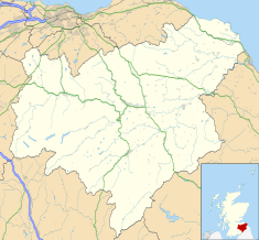
The Scottish Borders is one of 32 council areas of Scotland. It is bordered by West Lothian, Edinburgh, Midlothian, and East Lothian to the north, the North Sea to the east, Dumfries and Galloway to the south-west, South Lanarkshire to the west, and the English ceremonial counties of Cumbria and Northumberland to the south. The largest settlement is Galashiels, and the administrative centre is Newtown St Boswells.

<span class="mw-page-title-main">Berwickshire</span> Historic county in Scotland

Berwickshire is a historic county, registration county and lieutenancy area in south-eastern Scotland, on the English border. The county takes its name from Berwick-upon-Tweed, its original county town, which was part of Scotland at the time of the county's formation in the twelfth century, but became part of England in 1482 after several centuries of swapping back and forth between the two kingdoms. After the loss of Berwick, Duns and Greenlaw both served as county town at different periods.

<span class="mw-page-title-main">Jedburgh</span> Town in Scotland

Jedburgh is a town and former royal burgh in the Scottish Borders and the traditional county town of the historic county of Roxburghshire, the name of which was randomly chosen for Operation Jedburgh in support of the D-Day invasion.

<span class="mw-page-title-main">Roxburghshire</span> Historic county in Scotland

Roxburghshire or the County of Roxburgh is a historic county and registration county in the Southern Uplands of Scotland. It borders Dumfriesshire to the west, Selkirkshire and Midlothian to the northwest, and Berwickshire to the north. To the southwest it borders Cumberland and to the southeast Northumberland, both in England.

<span class="mw-page-title-main">Selkirkshire</span> Historic county = in Scotland

Selkirkshire or the County of Selkirk is a historic county and registration county of Scotland. It borders Peeblesshire to the west, Midlothian to the north, Roxburghshire to the east, and Dumfriesshire to the south. It derives its name from its county town, the royal burgh of Selkirk. The county was historically also known as Ettrick Forest.

<span class="mw-page-title-main">Ettrick and Lauderdale</span> Former local government district in Scotland

Ettrick and Lauderdale was one of four local government districts in the Borders region of Scotland as well as a lieutenancy area from 1975 to 1996.

<span class="mw-page-title-main">Newtown St Boswells</span> Human settlement in Scotland

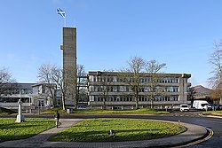
Newtown St Boswells is a village in the historic county of Roxburghshire which houses the administrative centre of the Scottish Borders council area. The village lies south of the Eildon Hills on the Sprouston and Newtown burns, between the larger settlements of St Boswells 1 mile (1.6 km) to the south-east and Melrose 2.5 miles (4.0 km) to the north-west.

George Mathers, 1st Baron Mathers KT, PC, DL was a Scottish trade unionist and Labour Party politician. He served as Comptroller of the Household from 1944 to 1945 in Winston Churchill's war-time coalition government and as Treasurer of the Household from 1945 to 1946 in Clement Attlee's post-war Labour administration.

Minto is a village and parish in the Scottish Borders area of Scotland in Roxburghshire county. It is located 6 miles north-east of Hawick, north of the River Teviot.

Maxton is a hamlet and civil parish in Roxburghshire, Scotland, and part of the Scottish Borders region.

<span class="mw-page-title-main">Alexander Jeffrey</span> Scottish solicitor and historian

Alexander Jeffrey F.S.A. (Scot) was a solicitor and local historian who spent most of his adult life in Jedburgh, Roxburghshire. He was known as the Historian of Roxburghshire.

<span class="mw-page-title-main">Bedrule</span> Hamlet and civil parish in the Scottish Borders

Bedrule is a hamlet and civil parish in the historic county of Roxburghshire in the Scottish Borders area of Scotland. The hamlet lies on the east side of the Rule Water, which gave the village its name, about 4 miles west of Jedburgh. It lies south of the A698 between Hawick and Jedburgh. Other local place-names based on the river include Hallrule, Abbotrule, Ruletownhead and Spittal-on-Rule. Larger settlements include Bonchester Bridge and Denholm, as well as Hawick and Jedburgh.

<span class="mw-page-title-main">The Kelso and Jedburgh railway branch lines</span> Former railway lines in Scotland

The Railway of Kelso and Jedburgh branch lines was a 'network' of three distinct railway services serving Kelso in the Scottish Borders.

<span class="mw-page-title-main">Mertoun</span> Human settlement in Scotland

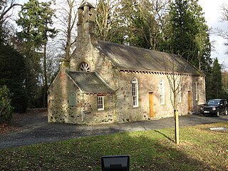
Mertoun is a parish in the south-west of the historic county of Berwickshire in the Scottish Borders area of Scotland. Together with the parish of Maxton, Roxburghshire it forms the Maxton and Mertoun Community Council area. It was included in the former Ettrick and Lauderdale District of Borders Region, by the Local Government (Scotland) Act 1973, from 1975 to 1996.

<span class="mw-page-title-main">Jedburgh Library</span> Building in Jedburgh, Scotland

Jedburgh Library is now housed in the second building built for Andrew Carnegie in Jedburgh at a cost of £1,700. It was one of the many libraries built by Carnegie. There have been subscription libraries in the town since at least 1780 and at one time there were three or four. This library has been open since the start of the 20th century but plans in 2020 were revealed to close it.

<span class="mw-page-title-main">Hawick Town Hall</span> Municipal building in Hawick, Scotland

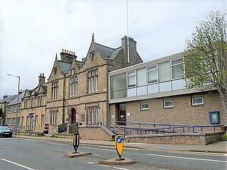
Hawick Town Hall is a municipal building in the High Street, Hawick, Scotland. The structure, which served as the meeting place of Hawick Burgh Council, is a Category A listed building.

<span class="mw-page-title-main">Coldstream Town Hall</span> Municipal building in Coldstream, Scotland

Coldstream Town Hall is a municipal building in the High Street, Coldstream, Scottish Borders, Scotland. The structure, which currently accommodates a library and a registration office, is a Category B listed building.

<span class="mw-page-title-main">County Buildings, Duns</span> Courthouse in Duns, Scotland

County Buildings is a municipal structure in Newtown Street, Duns, Scottish Borders, Scotland. The complex, which was the headquarters of Berwickshire County Council and was also used as a courthouse, is a Category C listed building.

References

  1. Historic Environment Scotland. "Jedburgh Sheriff Court and Justice of the Peace Court (Former County Buildings) including wall and railings, Castlegate, Jedburgh (Category B Listed Building) (LB35503)" . Retrieved 12 December 2022.
  2. "Roxburgh County Council". Kelso Mail. 28 May 1890. p. 3. Retrieved 12 December 2022.
  3. "Roxburgh County Council". Jedburgh Gazette. 16 May 1896. p. 4. Retrieved 12 December 2022.
  4. "Ordnance Survey 25 inch map". National Library of Scotland. 1898. Retrieved 12 December 2022.
  5. "Roxburgh Education Authority: New education offices". Southern Reporter. Selkirk. 20 December 1928. p. 8. Retrieved 12 December 2022.
  6. "Roxburgh County Council". Jedburgh Gazette. 6 June 1930. p. 1. Retrieved 13 December 2022.
  7. "County Council meeting: Jedburgh meeting place to be abandoned". Hawick News. 19 December 1930. p. 6. Retrieved 13 December 2022.
  8. "Roxburgh County Buildings". Dictionary of Scottish Architects. Retrieved 13 December 2022.
  9. "Roxburgh County Offices, Newtown St Boswells". Canmore. Historic Environment Scotland. Retrieved 13 December 2022.
  10. Aerial photograph of Newtown St Boswells, with the Council Headquarters top centre, showing how the post 1968 buildings almost completely surround the 1928 building: "Oblique aerial view centred on the railway station, engine shed and Newtown St Boswells town, taken from the SE". Canmore. Historic Environment Scotland. 2007. Retrieved 13 December 2022.
  11. "Local Government (Scotland) Act 1973", legislation.gov.uk , The National Archives, 1973 c. 65, retrieved 22 November 2022
  12. "No. 19753". The Edinburgh Gazette . 10 October 1975. p. 1319.
  13. "Local Government etc. (Scotland) Act 1994", legislation.gov.uk , The National Archives, 1994 c. 39, retrieved 13 December 2022
  14. "No. 23789". The Edinburgh Gazette . 26 May 1895. p. 1333.
  15. "No. 23993". The Edinburgh Gazette . 24 May 1996. p. 1282.