County Lock

Last updated

County Lock, looking downstream. Brewery Gut is entered under the bridge in the distance. County Lock, sunset.jpg
County Lock, looking downstream. Brewery Gut is entered under the bridge in the distance.
The lower lock gates, with the river in a state of flood. The old brewery stable block can be seen. County Lock in flood, Reading.jpg
The lower lock gates, with the river in a state of flood. The old brewery stable block can be seen.
County Lock in 1975 with Simonds' Brewery in background. County Lock, River Kennet, Reading - geograph.org.uk - 381837.jpg
County Lock in 1975 with Simonds' Brewery in background.

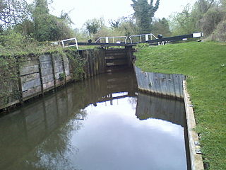
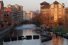
County Lock is a lock on the River Kennet in Reading town centre in the English county of Berkshire. It is now administered by the Canal & River Trust as part of the Kennet and Avon Canal. Downstream from the lock is Brewery Gut, a particularly fast flowing, narrow and dangerous stretch of the river. [1] [2]

Contents

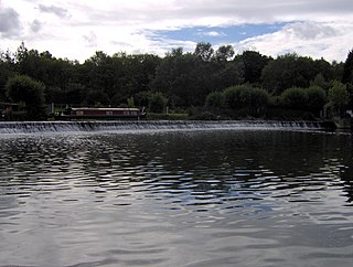
County Lock has the lowest rise of the locks on the Kennet, as boats only rise or fall about 30 cm (1 foot) in the lock. The main stream of the Kennet flows down the weir on the far side of the lock, while another arm of the Kennet disappears under the Bridge Street Roundabout. [3]

The first County Lock was built between 1718 and 1723, during the navigation works undertaken under the supervision of the engineer John Hore of Newbury in order to create the Kennet Navigation between Reading and Newbury. Initially the lock was located on the north side of the river, adjacent to Bear Wharf, but it was relocated to its current location on the south bank as part of the Reading waterworks improvement scheme of 1876. [1] [2]

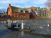
The land on both sides of the river adjacent to County Lock was formerly part of the site of Simonds Brewery. Brewery Gut takes its name from the brewery. In the days of horse haulage, this stretch of river had no towpath, and a long tow line had to be sent down-river on a specially designed float. To add to the difficulty, at its narrowest the gut is only 25 feet (7.6 m) wide, causing strong currents. Multiple vessels cannot safely pass due to the tortuous and narrow route, and there have been instances in the past of boats colliding and sinking. Today passage through the gut is controlled by traffic lights. [2]

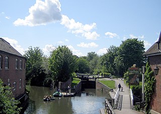
Simonds' Brewery closed in the late 1970s, and most of the brewery buildings have been demolished. Around the lock itself they have been replaced by a mixture of apartments and offices, although the brewery's old stable building, which overlooks the lock, has been preserved and was formerly occupied by a Loch Fyne restaurant. The part of the brewery that enveloped Brewery Gut has been replaced by The Oracle shopping centre, and boats can be seen navigating through the middle of the Riverside Level of that complex, lined on both sides by restaurants and pubs.

See also

Related Research Articles

<span class="mw-page-title-main">Kennet and Avon Canal</span> Canal in southern England

The Kennet and Avon Canal is a waterway in southern England with an overall length of 87 miles (140 km), made up of two lengths of navigable river linked by a canal. The name is used to refer to the entire length of the navigation rather than solely to the central canal section. From Bristol to Bath the waterway follows the natural course of the River Avon before the canal links it to the River Kennet at Newbury, and from there to Reading on the River Thames. In all, the waterway incorporates 105 locks.

<span class="mw-page-title-main">Blake's Lock</span>

Blake's Lock is a lock situated on the River Kennet in Reading, Berkshire, England. It is on the short reach of the River Kennet which is administered as if it were part of the River Thames and is hence owned and managed by the Environment Agency.

<span class="mw-page-title-main">Fobney Lock</span>

Fobney Lock is a lock on the River Kennet in the Small Mead area of Reading in the English county of Berkshire. Between the lock cut for the lock and the river itself is Fobney Island, which is a nature reserve.

<span class="mw-page-title-main">Southcote Lock</span>

Southcote Lock is a lock on the River Kennet at Southcote near the town of Reading in Berkshire, England. It has a rise/fall of 5 feet 3 inches (1.60 m).

<span class="mw-page-title-main">Keynsham Lock</span>

Keynsham Lock is a canal lock situated on the River Avon at Keynsham, England.

<span class="mw-page-title-main">Swineford Lock</span>

Swineford Lock is a canal lock situated on the River Avon, at the village of Swineford, England.

<span class="mw-page-title-main">Saltford Lock</span> Canal lock on the River Avon, England

Saltford Lock is a canal lock situated on the River Avon, at the village of Saltford, between Bristol and Bath, England.

<span class="mw-page-title-main">Kelston Lock</span>

Kelston Lock is a canal lock situated on the River Avon, between the villages of Kelston and Saltford, between Bristol and Bath, England.

<span class="mw-page-title-main">Weston Lock</span>

Weston Lock is a canal lock situated on the River Avon, on the western outskirts of Bath, England, in what now forms the Newbridge suburb of Bath.

<span class="mw-page-title-main">Tyle Mill Lock</span>

Tyle Mill Lock is a lock situated near Tyle Mill and the village of Sulhamstead on the Kennet and Avon Canal, England.

<span class="mw-page-title-main">Garston Lock</span>

Garston Lock is a lock on the Kennet and Avon Canal. It is near the M4 motorway and near Reading, England.

<span class="mw-page-title-main">Burghfield Lock</span>

Burghfield Lock is a lock on the River Kennet at Burghfield in the English county of Berkshire.

<span class="mw-page-title-main">Sulhamstead Lock</span>

Sulhamstead Lock is a lock on the River Kennet to the east of Sulhamstead in the English county of Berkshire.

<span class="mw-page-title-main">Newbury Lock</span>

Newbury Lock is a lock on the Kennet and Avon Canal in the town centre of Newbury, in the English county of Berkshire. It has a rise/fall of 3 ft 6 in, and is situated just upstream of Newbury Bridge.

<span class="mw-page-title-main">Woolhampton Lock</span>

Woolhampton Lock is a lock on the Kennet and Avon Canal, in the village of Woolhampton in the English county of Berkshire. The lock has a rise/fall of 8 feet 11 inches (2.72 m) and is administered by the Canal and River Trust.

<span class="mw-page-title-main">Caen Hill Locks</span> Flight of locks on the Kennet and Avon Canal

Caen Hill Locks are a flight of 29 locks on the Kennet and Avon Canal, between Rowde and Devizes in Wiltshire, England.

<span class="mw-page-title-main">John Hore</span>

John Hore was an English engineer, best known for making the River Kennet and River Avon navigable. Hore was one of the earliest English canal engineers, and Sir Alec Skempton wrote that he was "in the first rank among the navigation engineers". The Hutchinson Chronology of World History described his work on the Kennet navigation as "[setting] a new standard for inland waterways, and is an important forerunner of the canals of the Industrial Revolution".

<span class="mw-page-title-main">High Bridge, Reading</span> Bridge in Reading

High Bridge, sometimes known as Duke Street Bridge, is a bridge across the River Kennet in the town centre of Reading in the English county of Berkshire. It links Duke Street, to its north, and London Street, to its south. High Bridge is the oldest surviving bridge across the Kennet, and is a grade II listed building. It comprises a single arch of vermiculated Portland stone, with a plain keystone of ashlar.

<span class="mw-page-title-main">Bridge Street, Reading</span>

Bridge Street, formerly known as Seven Bridges, is a historic street in the town of Reading in the English county of Berkshire. It took its original name from the seven bridges that carried it over various channels of the River Kennet, and was the earliest crossing place of that river in the town.

References

  1. 1 2 Clew, Kenneth R (1978). Wessex Waterway - A Guide to the Kennet & Avon Canal. p. 9.
  2. 1 2 3 Clew, Kenneth R (1978). Wessex Waterway - A Guide to the Kennet & Avon Canal. pp. 15–16.
  3. "County Lock". Reading History Trail. Archived from the original on 24 September 2006. Retrieved 17 September 2006.

Bibliography

Next lock upstream River Kennet Next lock downstream
Fobney Lock County Lock
Grid reference SU713729
Blake's Lock

Coordinates: 51°27′04″N0°58′25″W / 51.45111°N 0.973673°W / 51.45111; -0.973673