
Stafford is a market town and the county town of Staffordshire, England. It is located about 15 miles (24 km) south of Stoke-on-Trent, 15 miles (24 km) north of Wolverhampton, and 24 miles (39 km) northwest of Birmingham. The town had a population of 71,673 in 2021, and is the main settlement within the larger Borough of Stafford, which had a population of 136,837 in 2021.
South Staffordshire is a local government district in Staffordshire, England. Its council is based in Codsall. Other notable settlements include Brewood, Cheslyn Hay, Coven, Essington, Featherstone, Four Ashes, Great Wyrley, Huntington, Kinver, Landywood, Penkridge, Perton, Wedge Mills, Weston-under-Lizard and Wombourne. The district covers a largely rural area lying immediately to the west and north-west of the West Midlands conurbation.
Penkridge is a large village and civil parish in South Staffordshire District in Staffordshire, England. It is to the south of Stafford, north of Wolverhampton, west of Cannock, east of Telford and south-east of Newport.

Penn is an area which is divided between the City of Wolverhampton and South Staffordshire district. The population of the Wolverhampton Ward taken at the 2011 census was 12,718. Originally, it was a village in the historic county of Staffordshire. There is considerable confusion about exactly which areas fall within Penn. In 19th century censuses, Merry Hill, Bradmore are understood to form part of Penn, although these areas are generally understood to be separate today. However, there has never been any doubt that the two historic settlements of Upper and Lower Penn form the core of the area.

Staffordshire is a landlocked county in the West Midlands of England. It adjoins Cheshire to the north west, Derbyshire and Leicestershire to the east, Warwickshire to the south east, West Midlands and Worcestershire to the south, and Shropshire to the west. The historic county of Staffordshire includes Wolverhampton, Walsall, and West Bromwich, these three being removed for administrative purposes in 1974 to the new West Midlands authority. The resulting administrative area of Staffordshire has a narrow southwards protrusion that runs west of West Midlands to the border of Worcestershire. The city of Stoke-on-Trent was removed from the admin area in the 1990s to form a unitary authority, but is still part of Staffordshire for ceremonial and traditional purposes.

Codsall is a large village in the South Staffordshire district of Staffordshire, England. It is situated 5 miles northwest of Wolverhampton and 13 miles east-southeast of Telford. It forms part of the boundary of the Staffordshire-West Midlands County border, along with Perton, the village is almost contiguous with Wolverhampton with very small amounts of greenbelt still separating the two settlements.
Oxley is a suburb of Wolverhampton, West Midlands, and a ward of the City of Wolverhampton Council. Its area code is WV10. It is situated in the north of the city, bordering South Staffordshire and the Bushbury North, Bushbury South and Low Hill, St Peter's and Tettenhall Regis wards. It forms part of the Wolverhampton North East constituency.

Bushbury is a suburban village and ward in the City of Wolverhampton in the West Midlands, England. It lies two miles north-east of Wolverhampton city centre, divided between the Bushbury North and Bushbury South and Low Hill wards. Bushbury also lies near to the villages of Coven, Featherstone and Four Ashes which are in South Staffordshire.

Wombourne is a large village and civil parish located in the district of South Staffordshire, in the county of Staffordshire, England. It is 4 miles (6 km) south-west of Wolverhampton and just outside the county and conurbation of the West Midlands.

Shenstone is a village and civil parish in The Lichfield District, Staffordshire, England, located between Lichfield and Sutton Coldfield. The parish also contains the village of Stonnall.

Brewood is an ancient market town in the civil parish of Brewood and Coven, in the South Staffordshire district, in the county of Staffordshire, England. Brewood lies near the River Penk, 8 miles (13 km) north of Wolverhampton and 11 miles (18 km) south of Stafford. Brewood is about 3 miles (4.8 km) east of the county border with Shropshire.
Featherstone is a town in the district of South Staffordshire, England, near to the border with Wolverhampton.

Essington is a village and civil parish in South Staffordshire, England, located near the city of Wolverhampton and towns of Walsall, Bloxwich, Cannock and Brewood. The villages of Cheslyn Hay, Great Wyrley, Coven, Penkridge and Featherstone are also nearby. The village forms part of the Staffordshire/West Midlands border.

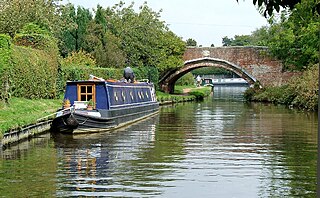
The River Penk is a small river flowing through Staffordshire, England. Its course is mainly within South Staffordshire, and it drains most of the northern part of that district, together with some adjoining areas of Cannock Chase, Stafford, Wolverhampton, and Shropshire. It flows into the River Sow, which is a tributary of the River Trent, so its waters flow ultimately into the North Sea via the Humber Estuary.

Pattingham is a village and former civil parish, now in the parish of Pattingham and Patshull, in the South Staffordshire district, in the county of Staffordshire, England, near the county boundary with Shropshire. Pattingham is seven miles west of Wolverhampton and seven and a half miles east of Bridgnorth. In 2021 it had a population of 1773.
Himley is a small village and civil parish in Staffordshire, England, 4 miles (6.4 km) west of Dudley and 5 mi (8.0 km) southwest of Wolverhampton. At the 2011 Census, it had a population of 802. Himley Hall was the home of the Lords of Dudley.

Four Ashes railway station was a railway station built by the Grand Junction Railway in 1837. It served the small village of Four Ashes, Staffordshire, 6 miles north of Wolverhampton City Centre, and was located near to the A449 road, on Station Drive. It was also the closest station to the villages of Coven and Featherstone as well as the town of Brewood.

Gailey is a small village in Staffordshire, England. It is at the junction of the A5 and A449 roads, and is on the boundary of the parishes of Brewood and Coven and Penkridge, in South Staffordshire.

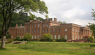
Black Ladies Priory was a house of Benedictine nuns, located about 4 km west of Brewood in Staffordshire, on the northern edge of the hamlet of Kiddemore Green. Founded in the mid-12th century, it was a small, often struggling, house. It was dissolved in 1538, and a large house was built on the site in Tudor and Jacobean styles by the Giffard family of Chillington Hall. Much of this is incorporated in the present Black Ladies, a large, Grade II*-listed, private residence.

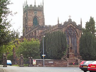
St Paul's Church, Coven is a Grade II listed parish church in the Church of England in Coven, Staffordshire

