The Vale of Glamorgan, often referred to as The Vale, is a county borough in the south-east of Wales. It borders Bridgend County Borough to the west, Cardiff to the east, Rhondda Cynon Taf to the north, and the Bristol Channel to the south. With an economy based largely on agriculture and chemicals, it is the southernmost unitary authority in Wales. Attractions include Barry Island Pleasure Park, the Barry Tourist Railway, Medieval wall paintings in St Cadoc's Church, Llancarfan, Porthkerry Park, St Donat's Castle, Cosmeston Lakes Country Park and Cosmeston Medieval Village. The largest town is Barry. Other towns include Penarth, Llantwit Major, and Cowbridge. There are many villages in the county borough.

The A48 is a trunk road in Great Britain running from the A40 at Highnam, 3 miles (4.8 km) west of Gloucester, England, to the A40 at Carmarthen, Wales. Before the Severn Bridge opened on 8 September 1966, it was a major route between England and South Wales. For most of its route, it runs almost parallel to the M4 motorway. During times of high winds at the Severn Bridge, the A48 is used as part of the diversion route and is still marked as a Holiday Route.

Ely is a district and community in Cardiff, Wales. It is to the north of Cowbridge Road West. Caerau defines the boundary to the south as does River Ely to the east and in part to the north.

Canton is an inner-city district and community in the west of Cardiff, capital of Wales, lying 2 miles (3.2 km) west of the city's civic centre. Canton is one of the most ethnically diverse of Cardiff's suburbs, with a significant Pakistani and Indian population. The total population of Canton increased to 14,304 at the 2011 census. It is also the most Welsh-speaking district of central Cardiff, with 19.1% of the population speaking Welsh.

Culverhouse Cross is a district straddling the boundary between Cardiff and the Vale of Glamorgan, Wales, in the community of Wenvoe.

Fairwater is a district and community in the west of Cardiff, capital of Wales. It is located a few miles from Culverhouse Cross which connects Cardiff to the M4 motorway. The population taken at the 2011 census was 12,981.

Caerau is a community in the west of Cardiff, capital city of Wales. Often considered part of Wenvoe by gully, Heol Trelai is the main road or avenue, lined with large trees. Dominated mostly by private housing, it has the Western Leisure Centre, supermarkets, schools and churches.

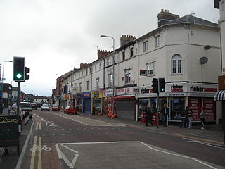
Cowbridge Road East is a major road in western-central Cardiff the capital of Wales. It is the principal road which passes through the busy district of Canton and connects Cowbridge Road West in the western districts to central Cardiff. The road is partly on the A4161. It is eventually crossed by Cathedral Road towards the city centre. It is home to numerous shops, pubs and restaurants.
Transport in Cardiff, capital and most populous city in Wales involves road, rail, bus, water and air. It is a major city of the United Kingdom and a centre of employment, government, retail, business, culture, media, sport and higher education.

The A4232, which is also known either as the Peripheral Distributor Road (PDR) (Welsh: Ffordd Ddosbarthu Ymylol) or the Cardiff Link Road (Welsh: Ffordd Gyswllt Caerdydd), is a distributor road in Cardiff, the capital of Wales.

The A4119 links Tonypandy with Cardiff in South Wales.

The A4050 road connects Barry, Vale of Glamorgan with Culverhouse Cross on the outskirts of Cardiff, Wales. It is approximately 10 miles (16 km) long, and is the key link road between the M4 motorway and Cardiff International Airport.

The A4161 is a main road in Cardiff, Wales, United Kingdom. The main purpose of the road is to link the city centre with the M4 motorway in the west at junction 33, and in the east with the A48(M) motorway at St Mellons.

St. Nicholas is a small village in the Vale of Glamorgan, South Wales. It lies 2 miles west of the capital city, Cardiff and 7 miles from its city centre. St. Nicholas is the highest elevation village in the Vale of Glamorgan. The population was 417 in 2011. It is in the community of St Nicholas and Bonvilston.

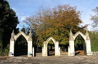
Western Cemetery is a major cemetery located in the western suburb of Ely, Cardiff, Wales. It is located near the Culverhouse Cross roundabout on the A48 road west of the city and provides burial facilities for people of all faiths.

The B4265 road is a main road in the Vale of Glamorgan, southeastern Wales, running in a northwesterly direction along near the coast. It links Cardiff Airport to Bridgend, lasting for 15.9 miles (25.6 km). The road begins at the roundabout near the airport and the village of Penmark at 51°24′21″N3°20′39″W as a continuation of the A4226 road leading from Barry. Passing the junction turnoff to Gileston and St Athan, at Llantwit Major, the B4270 road branches off to the northwest to Llandow Industrial Estate. The road then moves progressively in northwesterly direction until St Brides Major, where the B4524 road to the south connects it to Southerndown and Ogmore-by-Sea. At St Brides Major, the road shifts to a northerly direction, where it passes Ewenny and Ogmore village leading to Bridgend, where it joins the A48 road and finally A473 road at 51°30′7″N3°34′34″W.

Downs is a hamlet in the Vale of Glamorgan near the county border with the City of Cardiff. It lies just off the A48 road along a road called Grant's Field, just west of Culverhouse Cross and just south of the historical estate of Coedarhydyglyn. The village of St. Nicholas, Vale of Glamorgan lies to the west. The Traherne Arms lies along the main road near the village and, being near the top of The Tumble hill above Culverhouse Cross, has panoramic views of the Welsh capital of Cardiff.

Wenvoe Quarry is a quarry located between Wenvoe and Culverhouse Cross in the Vale of Glamorgan, south Wales. It is situated in an area close to the A4050 road known as "The Alps", not far from Caerau and Culverhouse Cross on the outskirts of Cardiff. The quarry extracts limestone rock from the Carboniferous Black Rock Limestone Sub-Group of the Pembroke Limestone Group and in particular the Friar’s Point Limestone. The rock is crushed and screened to produce a variety of construction aggregates.

Wenvoe Tunnel is a disused tunnel on the defunct Barry Railway that runs under Culverhouse Cross in the Vale of Glamorgan in south Wales, on the western outskirts of Cardiff. It was opened in 1889 on a line used to carry coal to Barry Docks. The line also had a sparse passenger service and closed after March 1963.
Canton is the name of an electoral ward in the west of the city of Cardiff, Wales, which covers part of its namesake community, Canton. The ward elects three county councillors to the County Council of the City and County of Cardiff.


