Crabtree Creek (Neuse River tributary)

Last updated
Crabtree Creek
Tributary to Neuse River
Crabtree Creek.jpg
Crabtree Creek east of Lassiter Mill Rd.
USA North Carolina relief location map.jpg
Red pog.svg
Location of Crabtree Creek mouth
Usa edcp relief location map.png
Red pog.svg
Crabtree Creek (Neuse River tributary) (the United States)
Location
Country United States
State North Carolina
County Wake
City Raleigh
Cary
Physical characteristics
Sourcebetween Cary, North Carolina and Apex, North Carolina, southwest of Bond Park
  location Cary, North Carolina
  coordinates 35°45′30″N078°50′41″W / 35.75833°N 78.84472°W / 35.75833; -78.84472 [1]
  elevation450 ft (140 m) [2]
Mouth Neuse River
  location
about 2 miles southeast of Wilders Grove, North Carolina
  coordinates
35°45′59″N078°32′22″W / 35.76639°N 78.53944°W / 35.76639; -78.53944 [1]
  elevation
157 ft (48 m) [1]
Length28.73 mi (46.24 km) [3]
Basin size145.27 square miles (376.2 km2)
Discharge 
  location Neuse River
  average174.58 cu ft/s (4.944 m3/s) at mouth with Neuse River [4]
Basin features
Progression Neuse RiverPamlico SoundAtlantic Ocean
River system Neuse River
Tributaries 
  left Turkey Creek
Stirrup Iron Creek

Haleys Branch
Sycamore Creek
Hare Snipe Creek
Mine Creek
Big Branch
Marsh Creek
  right Coles Branch
Reedy Creek
Richland Creek
House Creek
Beaverdam Creek
Pigeon House Branch
Bridges Branch
Waterbodies Lake Crabtree
Bond Lake

Crabtree Creek is a tributary of the Neuse River in central Wake County, North Carolina, United States. The creek begins in the town of Cary and flows through Morrisville, William B. Umstead State Park, and the northern sections of Raleigh (roughly along I-440) before emptying into the Neuse at Anderson Point Park, a large city park located in East Raleigh.

Contents

History

The dam across Crabtree Creek at Lassiter Mill. Lassiter Mill dam.jpg
The dam across Crabtree Creek at Lassiter Mill.
City of Raleigh plaque at Lassiter Mill. Lassiter Mill plaque.jpg
City of Raleigh plaque at Lassiter Mill.

Lassiter Mill

According to the City of Raleigh plaque at the site, one of Wake County's first mills was located on Crabtree Creek at a site known as "the Great Falls of Crabtree." The first mill was constructed before 1764, and the current foundations are remnants of a grist mill constructed by Cornelius Jesse Lassiter in 1908. The mill was destroyed by fire in 1958. Today, the Lassiter Mill site is a Raleigh City park, part of the greenway system, and is open to the public.

Flooding

The creek lies within a flood plain that is historically prone to frequent flooding throughout its length, even after moderate rainfall. Construction of lakes on the creek and its tributaries to control floods have only partially alleviated this problem because rapid development of Wake County has greatly increased storm runoff. Crabtree Valley Mall derives its name from the creek; when the mall was constructed, the creek was redirected into an artificial channel behind the mall. At the time of construction there were predictions that the mall would flood. In fact, the new channel of the creek at the mall has proved to be inadequate for peak flows.

The highest recorded level of Crabtree Creek, measured at Glenwood Avenue near the mall, was 27.69 feet (8.44 m) in June 1973 shortly after the mall's completion. Tropical Storm Alberto (2006) caused the second highest elevation on record, 23.77 feet (7.25 m); and Hurricane Fran in September 1996 caused the third highest elevation, 23.00 feet (7.01 m). All three events flooded the lower level of the mall, inundated the mall's parking lots, and obstructed traffic in the vicinity. Even moderate storms wreak minor havoc around the mall; for instance, a storm in June 2006 caused an evacuation of the mall and significant property damage.

The United States Geological Survey has a monitoring station on Crabtree Creek at highway 70 in Raleigh. [5] The station's data goes enables better modeling and predictions of flooding. [5]

Dams

Numerous flood control dams have been built on Crabtree Creek.

In 1970, an earth dam was built in the Cary/Morrisville area. [6] The U.S. Department of Agriculture Natural Resources Conservation Services (USDA NRCS) designed dam is 1,320 feet long and 45 feet tall. [6] Originally called Crabtree Creek W/S Structure #3, the dam is now called the Fred G. Bond Dam because of its association with Bond Lake and the Fred G. Bond Metro Park in Cary. [6] [7] The dam was repaired during the winter between January 2016 and January 2020. [7]

In the Cary/Morrisville area, the creek was dammed in 1988 to create Lake Crabtree, a 520-acre (2.1 km2) flood control lake. [8] Lake Crabtree Dam or Crabtree W/S Structure #23 is an earth structure 1,200 feet long and 45 feet tall, designed by USDA NRCS. [8] Lake Crabtree County Park, Raleigh's Crabtree Boulevard and Raleigh's Crabtree Park are all either named after the creek or the adjoining lake. The Crabtree Creek Trail, a branch of the Capital Area Greenway, follows the course of the creek from a location just west of Crabtree Valley Mall to the confluence with the Neuse River at Anderson Point Park.

Crabtree Creek Greenway

The Crabtree Creek greenway is a 14.6 miles (23.5 km) paved trail that follows Crabtree Creek northwest from the Neuse River Trail beginning at Anderson Point Park to Lindsay Dr. [9] The final 4.1 miles (6.6 km) "east extension" section was completed in 2015 connecting the existing trail at Milburnie Road to the Neuse River Trail at Anderson Point Park. The city is planning a "west extension" (which will extend the 14.6 miles) to Umstead State Park. That project's planning will take approximately 12 months to complete with construction beginning on 2021-10. [10] The completed Crabtree Creek Trail will extend across the city, connecting numerous important areas and facilities: Umstead State Park, Crabtree Valley Mall, North Raleigh, Shelley Lake, Sertoma Park, Lassiter Mill, Kiwanis Park, and Anderson Point Park. [11] As of 2023 the section between Duraleigh Road and Umstead State Park is open. [12]

Watershed

Crabtree Creek in Cary, NC Crabtree Creek in Cary, NC.png
Crabtree Creek in Cary, NC

Tributaries

Tributaries of Crabtree Creek (Neuse River tributary)
Name, BankWatershed Area in Square Miles (km2) [13] Average Discharge [14] Mouth Coordinates [15] Mouth Elevation [15] Source Coordinates [15] Source Elevation [16] Remarks
Mouth145.27 square miles (376.2 km2)174.58 cu ft/s (4.944 m3/s) 35°45′59″N078°32′22″W / 35.76639°N 78.53944°W / 35.76639; -78.53944 157 ft (48 m) 35°45′30″N078°50′41″W / 35.75833°N 78.84472°W / 35.75833; -78.84472 450 ft (140 m)Crabtree Creek begins between Cary, North Carolina and Apex, North Carolina southwest of Bond Park. The creek drains a large part of Raleigh, North Carolina.
Marsh Creek, left bank9.58 square miles (24.8 km2)13.24 cu ft/s (0.375 m3/s) 35°47′43″N078°35′43″W / 35.79528°N 78.59528°W / 35.79528; -78.59528 174 ft (53 m) 35°52′19″N078°37′03″W / 35.87194°N 78.61750°W / 35.87194; -78.61750 408 ft (124 m)Marsh Creek rises near Northridge Country Club in Raleigh, North Carolina on the divide of it and Perry Creek. The creek then flows southeast to Crabtree Creek.
Bridges Branch, right bank0.46 square miles (1.2 km2)0.59 cu ft/s (0.017 m3/s) 35°48′13″N078°36′30″W / 35.80361°N 78.60833°W / 35.80361; -78.60833 197 ft (60 m) 35°47′15″N078°47′15″W / 35.78750°N 78.78750°W / 35.78750; -78.78750 300 ft (91 m)Bridges Branch is the smallest named tributary to Crabtree Creek and drains Lions Park. It rises near St. Augustine's University and flows north to Crabtree Creek.
Pigeon House Branch, right bank4.69 square miles (12.1 km2)5.29 cu ft/s (0.150 m3/s) 35°48′16″N078°36′32″W / 35.80444°N 78.60889°W / 35.80444; -78.60889 190 ft (58 m) 35°47′20″N078°38′40″W / 35.78889°N 78.64444°W / 35.78889; -78.64444 280 ft (85 m)Pigeon House Branch rises in downtown Raleigh, North Carolina on the divide between it and Rocky Branch. It then flows northeast to Crabtree Creek in northeast Raleigh.
Big Branch, left bank3.98 square miles (10.3 km2)4.70 cu ft/s (0.133 m3/s) 35°49′05″N078°37′44″W / 35.81806°N 78.62889°W / 35.81806; -78.62889 200 ft (61 m) 35°51′54″N078°37′44″W / 35.86500°N 78.62889°W / 35.86500; -78.62889 400 ft (120 m)Big Branch rises in a pond on the divide between Big Branch and Mine Creek. It then flows south to Crabtree Creek.
Beaverdam Creek, right bank3.66 square miles (9.5 km2)4.36 cu ft/s (0.123 m3/s) 35°49′28″N078°38′52″W / 35.82444°N 78.64778°W / 35.82444; -78.64778 200 ft (61 m) 35°48′58″N078°39′41″W / 35.81611°N 78.66139°W / 35.81611; -78.66139 252 ft (77 m)Beaverdam Creek is formed at the confluence of Southeast Prong and Southwest Prong of the creek. Most of the creek flows through Carolina Country Club.
Mine Creek, left bank10.21 square miles (26.4 km2)11.59 cu ft/s (0.328 m3/s) 35°50′18″N078°39′51″W / 35.83833°N 78.66417°W / 35.83833; -78.66417 210 ft (64 m) 35°51′48″N078°38′25″W / 35.86333°N 78.64028°W / 35.86333; -78.64028 395 ft (120 m)Mine Creek rises to the west of Falls of the Neuse Road in Raleigh, North Carolina and then flows south through Shelley Lake and on to Crabtree Creek.
House Creek, right bank2.81 square miles (7.3 km2)3.36 cu ft/s (0.095 m3/s) 35°50′12″N078°40′35″W / 35.83667°N 78.67639°W / 35.83667; -78.67639 223 ft (68 m) 35°47′59″N078°42′00″W / 35.79972°N 78.70000°W / 35.79972; -78.70000 425 ft (130 m)House Creek rises in a lake on the campus of the North Carolina State University Veterinary School and then flows northeast to meet Crabtree Creek near Crabtree Valley Mall.
Hare Snipe Creek, left bank7.24 square miles (18.8 km2)8.18 cu ft/s (0.232 m3/s) 35°50′42″N078°41′20″W / 35.84500°N 78.68889°W / 35.84500; -78.68889 223 ft (68 m) 35°54′23″N078°43′02″W / 35.90639°N 78.71722°W / 35.90639; -78.71722 430 ft (130 m)Hare Snipe Creek rises about 0.5 miles southeast of Leesville, North Carolina and then flows southeast to meet Crabtree Creek upstream of Crabtree Valley Mall. Dammed by Lake Lynn.
Richland Creek, right bank6.84 square miles (17.7 km2)7.87 cu ft/s (0.223 m3/s) 35°50′42″N078°43′15″W / 35.84500°N 78.72083°W / 35.84500; -78.72083 226 ft (69 m) 35°47′19″N078°43′47″W / 35.78861°N 78.72972°W / 35.78861; -78.72972 440 ft (130 m)Richland Creek rises in a pond at the North Carolina State Fairgrounds and then flows north through Schenck Forest to meet Crabtree Creek about 1 mile west of Raleigh, North Carolina.
Sycamore Creek, left bank16.31 square miles (42.2 km2)17.26 cu ft/s (0.489 m3/s) 35°50′47″N078°43′33″W / 35.84639°N 78.72583°W / 35.84639; -78.72583 230 ft (70 m) 35°56′06″N078°45′02″W / 35.93500°N 78.75056°W / 35.93500; -78.75056 440 ft (130 m)Sycamore Creek rises in a pond about 0.1 miles northeast of Lynn Crossroads, North Carolina on the divide between it and Lick Creek. Sycamore Creek then flows generally southeast to meet Crabtree Creek about 1 mile west of Raleigh, North Carolina. Sycamore Creek flows most of its length through William B. Umstead State Park and has two impoundments, Big Lake and Sycamore Lake. Sycamore Creek is the second largest tributary to Crabtree Creek by both volume and drainage area.
Reedy Creek, right bank4.44 square miles (11.5 km2)5.14 cu ft/s (0.146 m3/s) 35°50′27″N078°44′36″W / 35.84083°N 78.74333°W / 35.84083; -78.74333 243 ft (74 m) 35°47′40″N078°45′44″W / 35.79444°N 78.76222°W / 35.79444; -78.76222 460 ft (140 m)Reedy Creek rises near the WPTF radio towers in Cary, North Carolina and then flows north through William B. Umstead State Park to Crabtree Creek. Reedy Creek Lake is an impoundment of this stream.
Haleys Branch, left bank2.19 square miles (5.7 km2)2.51 cu ft/s (0.071 m3/s) 35°50′18″N078°47′04″W / 35.83833°N 78.78444°W / 35.83833; -78.78444 272 ft (83 m) 35°52′07″N078°47′05″W / 35.86861°N 78.78472°W / 35.86861; -78.78472 385 ft (117 m)Haleys Branch rises just south of the Raleigh-Durham International Airport (RDU) on the Little Brier Creek divide and then flows south to meet Crabtree Creek in Lake Crabtree.
Stirrup Iron Creek, left bank26.05 square miles (67.5 km2)27.35 cu ft/s (0.774 m3/s) 35°50′15″N078°47′50″W / 35.83750°N 78.79722°W / 35.83750; -78.79722 272 ft (83 m) 35°56′01″N078°50′40″W / 35.93361°N 78.84444°W / 35.93361; -78.84444 400 ft (120 m)Stirrup Iron Creek rises in a pond by Brassfield, Granville County, North Carolina on the divide of Northeast Creek and then flows southeast to meet Crabtree Creek in Lake Crabtree. Stirrup Iron Creek is the largest tributary to Crabtree Creek by both volume and drainage area.
Coles Branch, right bank2.60 square miles (6.7 km2)3.13 cu ft/s (0.089 m3/s) 35°48′10″N078°50′02″W / 35.80278°N 78.83389°W / 35.80278; -78.83389 305 ft (93 m) 35°46′59″N078°48′19″W / 35.78306°N 78.80528°W / 35.78306; -78.80528 416 ft (127 m)Coles Branch rises in west Cary, North Carolina and then flows northwest to meet Crabtree Creek in Cary.
Turkey Creek, left bank1.80 square miles (4.7 km2)2.21 cu ft/s (0.063 m3/s) 35°48′07″N078°50′02″W / 35.80194°N 78.83389°W / 35.80194; -78.83389 305 ft (93 m) 35°46′39″N078°50′38″W / 35.77750°N 78.84389°W / 35.77750; -78.84389 400 ft (120 m)Turkey Creek rises near Upchurch, North Carolina and then flows northeast to meet Crabtree Creek in Cary, North Carolina.

Related Research Articles

<span class="mw-page-title-main">Wake County, North Carolina</span> County in North Carolina, United States

Wake County is located in the U.S. state of North Carolina. In the 2020 census, its population was 1,129,410, making it North Carolina's most-populous county. From July 2005 to July 2006, Wake County was the 9th-fastest growing county in the United States, with Cary and Raleigh being the 8th- and 15th-fastest growing cities, respectively.

<span class="mw-page-title-main">Morrisville, North Carolina</span> Town in North Carolina, United States

Morrisville is a town located primarily in Wake County, North Carolina, United States. The U.S. Census Bureau estimated the town's population to be 31,278 as of July 1, 2021. Morrisville is part of the Research Triangle metropolitan region. The regional name originated after the 1959 creation of the Research Triangle Park, located midway between the cities of Raleigh and Durham. The Research Triangle region encompasses the U.S. Census Bureau's Combined Statistical Area (CSA) of Raleigh-Durham-Cary. The estimated population of the Raleigh-Durham-Cary CSA was 2,144,608 as of 2021, with the Raleigh-Cary Metropolitan Statistical Area (MSA) portion estimated at 1,448,411 residents. The operational headquarters of Lenovo is located in the municipal limits.

<span class="mw-page-title-main">William B. Umstead State Park</span> State park in North Carolina, United States

William B. Umstead State Park is a North Carolina state park in Wake County, North Carolina in the United States. It covers 5,599 acres (22.66 km2) nestled between the expanding cities of Raleigh, Cary, and Durham, North Carolina. It offers hiking, bridle, and bike trails, boat rentals, camping, picnic areas, and educational programs.

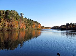
Lake Crabtree County Park is a park in Wake County, North Carolina. It is a forested area between Cary, Morrisville, and Raleigh-Durham International Airport, bounded by the northeastern shore of Lake Crabtree, I-40, and Aviation Parkway. The main entrance is on the Aviation Parkway side and is equipped with two playgrounds, a boat dock, bathrooms, an observation tower, and other amenities. A system of hiking and biking trails crosses through the park, with the most used one along the lakeshore. This trail connects the park entrance to the Black Creek Greenway-Old Reedy Creek Road intersection, near the entrance to William B. Umstead State Park.

<span class="mw-page-title-main">Falls, North Carolina</span> Unincorporated community in North Carolina, United States

Falls, is an unincorporated community in Wake County, North Carolina, United States, situated on Old Falls of Neuse Road, between Raleigh and Wake Forest, near the Wakefield Plantation development. Falls Dam, on the Neuse River, is within the community.

<span class="mw-page-title-main">Bond Park</span> Park in North Carolina

Fred G. Bond Metro Park is the largest municipal park in Cary, North Carolina. It is also one of the largest municipal parks in Wake County. It is located at 801 High House Road, physically the geographic center of the town. The park has been described as "an oasis in the middle of Cary".

<span class="mw-page-title-main">Neuse River Trail</span> Greenway trail in North Carolina, US

The Neuse River Trail is a 34.5-mile (55.5 km) long paved greenway located in the Raleigh area of North Carolina, running along the banks of the Neuse River from Falls Lake Dam to the town of Clayton. The route passes through the jurisdictions of Raleigh, Wake Forest, Knightdale, and Clayton in Wake and Johnston counties. The Neuse River Greenway trail is part of the Capital Area Greenway system as well as the Mountains-to-Sea Trail that crosses North Carolina from the Great Smoky Mountains to the Outer Banks. Open to both cyclists and pedestrians, the Neuse River Trail is the longest greenway trail in North Carolina and the longest paved trail between northern Virginia and western Georgia.

<span class="mw-page-title-main">Lake Lynn (Raleigh, North Carolina)</span> Man-made lake in Wake County, North Carolina

Lake Lynn is a man-made lake in Raleigh, North Carolina. The lake was created for flood control purposes in 1976 by damming Hare Snipe Creek, a tributary of Crabtree Creek. The lake has an area of 55.7 acres (22.5 ha) and lies entirely within the city of Raleigh's 75-acre (30 ha) Lake Lynn Park. The park includes a 2.8 mi (4.5 km) paved trail around the lake, as well as a community center, playground, and tennis courts.

<span class="mw-page-title-main">Sycamore Creek (Crabtree Creek tributary)</span> Stream in North Carolina, USA

Sycamore Creek is a tributary to Crabtree Creek that rises in a pond near Lynns Crossroads in Durham County then flows southward to join Crabtree Creek in Wake County, North Carolina. Sycamore Creek flows mostly through William B. Umstead State Park. The watershed is more forested at 43% than most in the Crabtree Creek watershed.

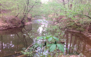
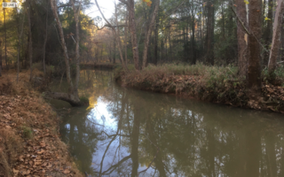
Reedy Creek is a 4.50 mi (7.24 km) long 2nd order tributary to Crabtree Creek in Wake County, North Carolina.

<span class="mw-page-title-main">Haleys Branch (Crabtree Creek tributary)</span> Stream in North Carolina, USA

Haleys Branch is a tributary to Crabtree Creek that rises just south of the Raleigh-Durham (RDU) airport then flows south to meet Crabtree Creek in Lake Crabtree. The watershed is about 68% forested.

<span class="mw-page-title-main">Stirrup Iron Creek</span> Stream in North Carolina, USA

Stirrup Iron Creek is a tributary to Crabtree Creek that rises near Brassfield, North Carolina and then flows south-southeast into Lake Crabtree. The watershed is about 31% forested.

Hare Snipe Creek is a tributary of Crabtree Creek that rises in the northern Raleigh, North Carolina. The creek then flows south to Lake Lynn and on to Crabtree Creek. The watershed is about 19% forested.

Mine Creek is a tributary of Crabtree Creek that rises in the northern Raleigh, North Carolina. The creek then flows southwest to Shelley Lake and then south to Crabtree Creek. The watershed is about 19% forested.

Big Branch is a 3.59 mi (5.78 km) long tributary of Crabtree Creek in Wake County, North Carolina, and is classed as a 2nd order stream on the EPA waters geoviewer site.

Marsh Creek is a 6.21 mi (9.99 km) long tributary to Crabtree Creek in Wake County, North Carolina and is classed as a 2nd order stream on the EPA waters geoviewer site.

Bridges Branch is a 1.26 mi (2.03 km) long tributary to Crabtree Creek in Wake County, North Carolina and is classed as a 1st order stream on the EPA waters geoviewer site.

House Creek is a 3.22 mi (5.18 km) long 1st order tributary of Crabtree Creek in Wake County, North Carolina.

Walnut Creek is a 17.93 mi (28.86 km) long 4th order tributary to the Neuse River in Wake County. Its source is a small pond near WakeMed Soccer Park in Cary, and it flows generally eastward through several small reservoirs, including Lake Cramer in Cary as well as Lake Johnson and Lake Raleigh in Raleigh, before reaching its confluence with the Neuse just south of Poole Road in East Raleigh. The course of the creek closely parallels Interstate 40, running mostly along the north side of the freeway.

References

  1. 1 2 3 "GNIS Detail - Crabtree Creek". geonames.usgs.gov. US Geological Survey. Retrieved 26 July 2019.
  2. "Coles Branch Topo Map, Wake County NC (Cary Area)". TopoZone. Locality, LLC. Retrieved 14 September 2019.
  3. "ArcGIS Web Application". epa.maps.arcgis.com. US EPA. Retrieved 26 July 2019.
  4. "Crabtree Creek Watershed Report". Waters Geoviewer. US EPA. Retrieved 26 July 2019.
  5. 1 2 "CRABTREE CREEK AT HWY 70 AT RALEIGH, NC". waterdata.usgs.gov. Retrieved 2022-03-04.
  6. 1 2 3 "Fred G. Bond Dam". National Dams. Retrieved 2022-03-03.
  7. 1 2 "Bond Lake Dam Repair". Alpha & Omega Group. Retrieved 2022-03-03.
  8. 1 2 "Lake Crabtree Dam". National Dams. Retrieved 2022-03-03.
  9. "Capital Area Greenway Trail System".
  10. "Crabtree Creek Trail West Extension".
  11. "Crabtree Creek Trail East Extension".
  12. ((https://raleighnc.gov/projects/crabtree-creek-west-trail))
  13. "ArcGIS Web Application". epa.maps.arcgis.com. US EPA. Retrieved 10 September 2019.
  14. "ArcGIS Web Application". epa.maps.arcgis.com. US EPA. Retrieved 24 August 2019.
  15. 1 2 3 "GNIS Feature Search". geonames.usgs.gov. US Geological Survey. Retrieved 24 August 2019.
  16. "Crabtree Creek Topo Map, Wake County NC (Raleigh East Area)". TopoZone. Locality, LLC. Retrieved 20 September 2019.