Cranford St Andrew

Last updated

Cranford St Andrew
Thatched Cottages in Cranford St Andrew - geograph.org.uk - 1179263.jpg
Northamptonshire UK location map (2021).svg
Red pog.svg
Cranford St Andrew
Location within Northamptonshire
OS grid reference SP921773
Civil parish
Unitary authority
Ceremonial county
Region
Country England
Sovereign state United Kingdom
Post town Kettering
Postcode district NN14
Dialling code 01536
Police Northamptonshire
Fire Northamptonshire
Ambulance East Midlands
UK Parliament
List of places
UK
England
Northamptonshire
52°23′12″N0°38′53″W / 52.38673°N 0.64794°W / 52.38673; -0.64794 Coordinates: 52°23′12″N0°38′53″W / 52.38673°N 0.64794°W / 52.38673; -0.64794

Cranford St Andrew is a village and former civil parish, now in the parish of Cranford, in the North Northamptonshire district, in the ceremonial county of Northamptonshire, England. It neighbours Cranford St John. In 1931 the parish had a population of 142. [1]

Contents

History

The name of the two villages of Cranford derives from two Old English words meaning ford frequented by cranes or herons. The villages of Cranford St Andrew and Cranford St John are not named separately in the Domeday Survey of 1086 but the two names are mentioned separately in 1254. "St Andrew" and "St John" refer to the dedications of the parish churches. [2]

The earliest part of the Church of St Andrew dates from about 1200. There is also later 12th century and maybe 13th work.

The hall was built in the early Georgian period and there have been later alterations. It was converted into flats in 1950. [3]

Iron ore was obtained in the Cranford St Andrew district for many years to the east and west of the village. On the east side quarrying began to the east of Cranford Hall in 1873 continuing to 1882 or a little later. There are quarries still visible on the west side of the road. There was also a quarry on the east side of the road which was extended later. The ore was taken to a siding close to Cranford Railway Station (now closed) by horse and three-wheeled cart. From there it was taken away by train to be smelted. Quarrying began again to the east of the road in 1908 until 1919 and again from 1934 to 1955. Quarrying began to the west of the road, further north than before between 1940 and 1958.

From 1908 until 1919 the ore was taken to the siding by steam operated metre gauge tramway. The later quarries used a steam operated standard gauge tramway. From 1946 to 56 there was also a gannister quarry near to the northernmost iron ore quarry. The gannister was taken to the main tramway by steam operated narrow gauge tramway. In the earlier periods quarrying was by hand with the aid of explosives. From 1918 a steam quarrying machine was introduced. From 1934 steam and diesel machines were used and electric machines were added to these from 1940. These quarries have not been landscaped and the quarry faces are still visible. [4]

On the west side of the village quarrying occurred between 1880 and 1889. The ore was taken to a railway siding west of the station by a tramway. It is not clear if horses or steam locomotives were used. In 1919 an adit was driven into the old quarry face and iron ore was mined using the pillar and stall method from then until 1926. In the latter stages the pillars holding the roof up were made narrower and after the mine was abandoned some of the tunnel roofs collapsed, causing sink holes or depressions in the ground. In some places they collapsed completely leaving gulleys with precipitous sides. Some of the holes and gulleys were later filled in. The mine was served by a cable operated tramway but ponies were used inside the mine and a larger horse at the tipping dock at the railway. [5]

There were also iron ore quarries and mines at Cranford St John.

On 1 April 1935 the parish was abolished to form "Cranford". [6]

See also

Related Research Articles

<span class="mw-page-title-main">Brixworth</span> Village in Northamptonshire, England

Brixworth is a large village and civil parish in West Northamptonshire, England. The 2001 census recorded a parish population of 5,162, increasing to 5,228 at the 2011 census. The village's All Saints' Church is of Anglo-Saxon origin.

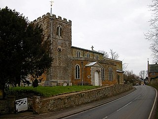
Scaldwell is a village and civil parish in the West, Northamptonshire, England.

<span class="mw-page-title-main">Pitsford</span> Village in Northamptonshire, England

Pitsford is a village and civil parish in West Northamptonshire in the United Kingdom. According to 2001 census, the parish's population was 636 people, increasing to 671 at the 2011 census.

<span class="mw-page-title-main">Lamport, Northamptonshire</span> Human settlement in England

Lamport is a village and civil parish in West Northamptonshire, England. The village is on the A508, about 8 miles (13 km) south of Market Harborough and 8 miles (13 km) north of Northampton. Nearby is Lamport Hall. At the time of the 2001 census, the parish's population was 207 people, including Hanging Houghton and increasing to 225 at the 2011 Census.

<span class="mw-page-title-main">Whiston, Northamptonshire</span> Human settlement in England

Whiston is a village and former civil parish, now in the parish of Cogenhoe and Whiston, in the West Northamptonshire district, in the ceremonial county of Northamptonshire, England. It is 4 miles due east of the county town of Northampton. In 1931 the parish had a population of 49.

Stowe Nine Churches is a civil parish incorporating the settlements of Church Stowe and Upper Stowe in the English county of Northamptonshire. The population of the civil parish at the 2011 census was 259.

<span class="mw-page-title-main">Ab Kettleby</span> Village in Leicestershire, England

Ab Kettleby is a village and civil parish in the Melton district of Leicestershire, England, located 3 miles (4.8 km) north of Melton Mowbray, on the A606 road. It had a population of 501 in 2001; at the 2011 census this had increased to 529.

<span class="mw-page-title-main">Sproxton, Leicestershire</span> Human settlement in England

Sproxton is a village and civil parish within the Borough of Melton in Leicestershire, England, close to the border with Lincolnshire. It has approximately 80 occupied dwellings (2021) and a population of 480, rising to 658 at the 2011 census.

<span class="mw-page-title-main">Blisworth</span> Human settlement in England

Blisworth is a village and civil parish in the West Northamptonshire, England. The West Coast Main Line, from London Euston to Manchester and Scotland, runs alongside the village partly hidden and partly on an embankment. The Grand Union Canal passes through the village and the north portal of the Blisworth tunnel is near Stoke Road.

<span class="mw-page-title-main">Islip, Northamptonshire</span> Human settlement in England

Islip is a village and civil parish in North Northamptonshire, England. The village is just west of Thrapston and 7 miles (11 km) east of Kettering. The parish is bounded to the east by the River Nene and to the north by Harpurs Brook, a tributary of the Nene. The 2011 Census recorded the parish's population as 829 people.

<span class="mw-page-title-main">Twywell</span> Human settlement in England

Twywell is an English village and civil parish in the county of Northamptonshire. Twywell Hills and Dales Country Park is adjacent. It lies just to the north of the A14 road, about three miles (5 km) west of Thrapston, and forms part of North Northamptonshire. At the time of the 2011 census, the population of the parish was 176.

<span class="mw-page-title-main">Knipton</span> Human settlement in England

Knipton is a village and former civil parish, now in the parish of Belvoir, in the Melton district, in the county of Leicestershire, England. It lies about 6 miles (10 km) from the town of Grantham, just off the A607, and 10 miles (16 km) from Melton Mowbray. It borders the Duke of Rutland's estate at Belvoir Castle. Although the village is in Leicestershire, it has a Nottinghamshire postcode and a Lincolnshire (Grantham) STD code. In 1931 the parish had a population of 273. On 1 April 1936 the parish was abolished and merged with Belvoir.

<span class="mw-page-title-main">Lowick, Northamptonshire</span> Human settlement in England

Lowick is a village and civil parish forming part of the district of North Northamptonshire, England, about 2 miles (3.2 km) north-west of Thrapston. It appears in the Domesday Book as Luhwik, and later as Lofwyk and in 1167 as Luffewich. The name derives from Old English "Luhha's or Luffa's dwelling place", wic being cognate to vicus in Latin. At the time of the 2011 census, the parish's population was 298 people.

<span class="mw-page-title-main">Cranford St John</span> Human settlement in England

Cranford St John is a village and former civil parish, now in the parish of Cranford, in the North Northamptonshire district, in the ceremonial county of Northamptonshire, England. It is in the southern half of the parish of Cranford, next to Cranford St Andrew - both named after the two parish churches. The two settlements are divided by the Alledge Brook, a tributary of the River Nene; the derivation of the name is "ford frequented by cranes or herons". In 1931 the parish had a population of 239. On 1 April 1935 the parish was abolished to form "Cranford".

<span class="mw-page-title-main">Slipton</span> Human settlement in England

Slipton is a village in the North Northamptonshire civil parish of Lowick. Slipton has a small but exquisite church, St John The Baptist, a short walk from Main Street by footpath on the east side of the village. The church is what makes Slipton a village rather than a hamlet as it is often mistaken for. The population of the village is included in the civil parish of Great Addington.

<span class="mw-page-title-main">Easton Neston</span> Human settlement in England

Easton Neston is situated in south Northamptonshire, England. Though the village of Easton Neston which was inhabited until around 1500 is now gone, the parish retains the name. At the 2011 Census the population of the civil parish remained less than 100 and was included in the town of Towcester.

<span class="mw-page-title-main">Finedonhill Tramway</span> Former industrial narrow-gauge railway in England

The Finedonhill Tramway was a British industrial narrow-gauge railway which operated under various ownership between 1875 and 1926.

<span class="mw-page-title-main">Wellingborough Tramway</span> Narrow-gauge railway in the United Kingdom

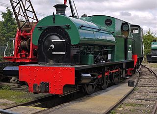
The Wellingborough Tramway was an industrial narrow-gauge railway that connected a series of ironstone mines and quarries with the Midland Railway and later with the ironworks on the north side of Wellingborough. In various forms, the tramway operated between 1875 and 1966.

Neilson's Tramway was a British industrial narrow-gauge railway which operated from 1881 to 1929.

The Eaton Branch Railway was a standard gauge industrial railway built to serve ironstone quarries around the village of Eaton in Leicestershire. It operated from 1884 until 1965.

References

  1. "Population statistics Cranford St Andrew AP/CP through time". A Vision of Britain through Time . Retrieved 27 March 2023.
  2. Mills, A.D. (1991). A Dictionary of English Place Names. Oxford: Oxford University Press. p. 94. ISBN   0-19-869156-4.
  3. Pevsner, Nikolaus (1973). Cherry, Bridget (ed.). Northamptonshire. Buildings of England (Second ed.). London: Penguin. p. 167. ISBN   0-14-0710-22-1.
  4. Tonks, Eric (1991). The Ironstone Quarries of the Midlands Part 5: The Kettering Area. Cheltenham: Runpast Publishing. p. 34–5 and 47–75. ISBN   1-870-754-050.
  5. Tonks Work already cited pages 36–45
  6. "Relationships and changes Cranford St Andrew AP/CP through time". A Vision of Britain through Time. Retrieved 27 March 2023.

Commons-logo.svg Media related to Cranford St Andrew at Wikimedia Commons