The military defense of Puerto Rico is the responsibility of the United States as part of the Treaty of Paris. Locally, Puerto Rico has its own National Guard, the Puerto Rico National Guard, and its own state defense force, the Puerto Rico State Guard, which, by local law, is under the authority of the Puerto Rico National Guard. The commander-in-chief of both forces is the governor of Puerto Rico, currently Pedro Pierluisi, who delegates his authority to the Puerto Rico Adjutant General, currently Major General José J. Reyes. The Adjutant General, in turn, delegates the authority over the State Guard to another officer but retains the authority over the Puerto Rico National Guard as a whole. At the national level, the commander-in-chief is the President of the United States, currently Joe Biden.
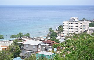
Aguadilla, founded in 1775 by Luis de Córdova, is a city and municipality located in the northwestern tip of Puerto Rico, bordered by the Atlantic Ocean to the north and west, north of Aguada, and Moca and west of Isabela. Aguadilla is spread over 15 barrios and Aguadilla Pueblo. It is a principal city and core of the Aguadilla-Isabela-San Sebastián Metropolitan Statistical Area.

Rafael Hernández International Airport is a joint civil-military airport located in Aguadilla, Puerto Rico. It is named after the Puerto Rican composer Rafael Hernández Marín. It is Puerto Rico's second largest international airport in terms of passenger movement. It is located in Porta del Sol tourist region, in Puerto Rico's west coast. It is also home to Coast Guard Air Station Borinquen and to the Caribbean Branch of the U.S. Customs and Border Protection Air and Marine Operations. The airport has the longest runway in the Caribbean region.

Isabela is a town and municipality of Puerto Rico located in the north-western region of the island, north of San Sebastián; west of Quebradillas; and east of Aguadilla and Moca. It is named in honor of Queen Isabella I of Castile. Isabela is spread over 13 barrios and Isabela Pueblo, which is the downtown area and administrative center. It is a principal part of the Aguadilla-Isabela-San Sebastián Metropolitan Statistical Area.

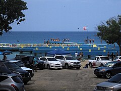
Rincón is a popular beach town and municipality of Puerto Rico founded in 1771 by Don Luis de Añasco, who previously founded Añasco in 1733. It is located in the Western Coastal Valley, west of Añasco and Aguada. Rincón is spread over 9 barrios and Rincón Pueblo. It is part of the Aguadilla-Isabela-San Sebastián Metropolitan Statistical Area.

Roosevelt Roads Naval Station, nicknamed Rosy Roads, is a former United States Navy base in the town of Ceiba, Puerto Rico. The site operates today as José Aponte de la Torre Airport, a public use airport.

Ramey Air Force Base also known as Borinquen Field, is a former United States Air Force base in Aguadilla, Puerto Rico. It was named after United States Army Air Forces Brigadier General Howard Knox Ramey. Following its closure, it was redeveloped into Rafael Hernandez Airport.

USCGC Escanaba (WMEC-907) is a United States Coast Guard medium endurance cutter based in Portsmouth, Virginia. Her keel was laid on April 1, 1983, at Robert Derecktor Shipyard Incorporated, Middletown, Rhode Island. She was launched February 6, 1985 and is named for her predecessor, USCGC Escanaba (WPG-77) which sank during World War Two, and was named for the Escanaba River and Escanaba, Michigan. Escanaba (WMEC-907) was formally commissioned August 29, 1987 in Grand Haven, Michigan, the home port of her predecessor.

The Puerto Rico Air National Guard(PR ANG) —Spanish: Guardia Nacional Aérea de Puerto Rico— is the aerial militia of the Commonwealth of Puerto Rico, an unincorporated territory of the United States of America. It is, along with the Puerto Rico Army National Guard and the Puerto Rico State Guard, an element of the Puerto Rico National Guard. After beginning as four units, the PRANG expanded to 11 units by the 1980s, including the 1956th Tactics Combat Group, the 140th Radar Squadron and others.

Coast Guard Air Station Borinquen is a United States Coast Guard Air Station located at the Rafael Hernandez International Airport, in Aguadilla, Puerto Rico.

The Puerto Rico Joint Forces of Rapid Action —Spanish: Fuerzas Unidas de Rapida Acción (FURA)— is an agency within the Puerto Rico Police in charge of specialized divisions that relate to federal law enforcement agencies of the United States, and coordinate operations between the PRPD and U.S. federal agencies. The force is a limited unit, well trained, and well recognized in the police. The force collaborates with law enforcement agencies of the federal government of the United States such as the Federal Bureau of Investigation, the Bureau of Alcohol, Tobacco, Firearms and Explosives, the United States Marshals Service, and the Department of Homeland Security among others.

Porta del Sol, or simply West Region, is a tourism region in western Puerto Rico. Porta del Sol was the first tourism region to be established by the Puerto Rico Tourism Company. It consists of 17 municipalities in the western area: Quebradillas, Isabela, San Sebastián, Moca, Aguadilla, Aguada, Rincón, Añasco, Mayagüez, Las Marías, Maricao, Hormigueros, San Germán, Sabana Grande, Guánica, Lajas and Cabo Rojo.
The 141st Air Control Squadron (ACS) is a unit of the Puerto Rico Air National Guard. It is a mobile radar command, control and communications element of the United States Air Force Theater Air Control System located at Punta Borinquen Radar Station near by Rafael Hernandez Airport formerly Ramey Air Force Base in Aguadilla, Puerto Rico.

Flamenco Beach is a public beach on the Caribbean island of Culebra. It is known for its shallow turquoise waters, white sand, swimming areas, and diving sites. It stretches for a mile around a sheltered, horseshoe-shaped bay. Playa Flamenco is a popular beach destination for both Culebra and Puerto Rico. In March 2014, Flamenco Beach was ranked 3rd best beach in the world with a TripAdvisor Travelers' Choice Award. In August 2016, it was announced that Flamenco Beach had regained its Blue Flag Beach international distinction.

Pozo de Jacinto is a blowhole located at Barrio Bajuras in the northwestern side Puerto Rican municipality of Isabela on Puerto Rico Highway 466.

Puerto Rico Highway 110 (PR-110) is a road that goes from Añasco, Puerto Rico to Aguadilla through Moca. It extends from Puerto Rico Highway 2 north of Añasco to Ramey Air Force Base.

Puerto Rico Highway 107 (PR-107), or Carretera Pedro Albizu Campos, is a north–south highway located in Aguadilla, Puerto Rico. It extends from PR-2 to Ramey Air Force Base.
Aviation in Puerto Rico has a complex and long history, almost as long as the history of aviation itself. Puerto Rican aviation history has been filled with events, well-known characters and airline companies which have shaped the country's transportation services and the way people travel between cities and to other countries.