
Brampton is a city in the Canadian province of Ontario. It is part of the Greater Toronto Area (GTA) and is a lower-tier municipality within the Peel Region. The city has a population of 656,480 as of the 2021 Census, making it the ninth most populous municipality in Canada and the third most populous city in the Greater Golden Horseshoe urban area, behind Toronto and Mississauga.

Mississauga is a Canadian city in the province of Ontario. Situated on the western shore of Lake Ontario in the Regional Municipality of Peel, it borders Toronto (Etobicoke) to the east, Brampton to the north, Milton to the northwest, and Oakville to the southwest. Although Mississauga was initially a car-centric city, significant strides have been made to improve walkability and add cycling lanes, with most major arteries having bi-directional bike lanes. The city's downtown is home to several transit hubs, such as Square One Bus Terminal, and the City Centre Transit Terminal. With a population of 717,961 as of 2021, Mississauga is the seventh-most populous municipality in Canada, third-most in Ontario, and second-most in the Greater Toronto Area (GTA) after Toronto itself. However, for the first time in its history, the city's population declined according to the 2021 census, from a 2016 population of 721,599 to 717,961, a 0.5 per cent decrease.

The Don River is a watercourse in southern Ontario that empties into Lake Ontario, at Toronto Harbour. Its mouth was just east of the street grid of the town of York, Upper Canada, the municipality that evolved into Toronto, Ontario. The Don is one of the major watercourses draining Toronto that have headwaters in the Oak Ridges Moraine.

The Humber River is a river in Southern Ontario, Canada. It is in the Great Lakes Basin, is a tributary of Lake Ontario and is one of two major rivers on either side of the city of Toronto, the other being the Don River to the east. It was designated a Canadian Heritage River on September 24, 1999.

The Regional Municipality of Peel is a regional municipality in the Greater Toronto Area, Southern Ontario, Canada. It consists of three municipalities to the west and northwest of the city of Toronto: the cities of Mississauga and Brampton, and the town of Caledon, each of which spans its full east–west width. The regional seat is in Brampton.

The Rouge River is a river in Markham, Pickering, Richmond Hill and Toronto in the Greater Toronto Area of Ontario, Canada. The river flows from the Oak Ridges Moraine to Lake Ontario at the eastern border of Toronto, and is the location of Rouge Park, the only national park in Canada within a municipality. At its southern end, the Rouge River is the boundary between Toronto and southwestern Pickering in the Regional Municipality of Durham.

The Credit River is a river in southern Ontario, which flows from headwaters above the Niagara Escarpment near Orangeville and Caledon East to empty into Lake Ontario at Port Credit, Mississauga. It drains an area of approximately 1,000 square kilometres (390 sq mi). The total length of the river and its tributary streams is over 1,500 kilometres (930 mi).
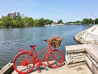
Port Credit is a neighbourhood in the south-central part of the City of Mississauga, Ontario, Canada, located at the mouth of the Credit River on the north shore of Lake Ontario. Its main intersection is Hurontario Street and Lakeshore Road, about 0.6 kilometres (0.37 mi) east of the river. Until 1974, Port Credit was an incorporated town. Its approximate boundaries are the Canadian National Railway to the north, Seneca Avenue to the east and Shawnmarr Road to the west. It had a population of 10,260 at the 2001 census.

Mimico Creek is a stream that flows through Brampton, Mississauga and Toronto in the Greater Toronto Area of Ontario, Canada. It is 33 kilometres (21 mi) long, is in the Great Lakes Basin, and is a tributary of Lake Ontario.
The Toronto and Region Conservation Authority (TRCA) is a conservation authority in southern Ontario, Canada. It owns about 16,000 hectares of land in the Toronto region, and it employs more than 400 full-time employees and coordinates more than 3,000 volunteers each year. TRCA's area of jurisdiction is watershed-based and includes 3,467 square kilometres (1,339 sq mi) – 2,506 on land and 961 water-based in Lake Ontario. This area comprises nine watersheds from west to east – Etobicoke Creek, Mimico Creek, Humber River, Don River, Highland Creek, Petticoat Creek, Rouge River, Duffins Creek and Carruthers Creek.
A conservation authority is a local, community-based natural resource management agency based in Ontario, Canada. Conservation authorities represent groupings of municipalities on a watershed basis and work in partnership with other agencies to carry out natural resource management activities within their respective watersheds, on behalf of their member municipalities and the Province of Ontario.

The Tay River is a river in Lanark County in Eastern Ontario, Canada. It is in the Saint Lawrence River drainage basin and is a left tributary of the Rideau River.
Conservation Halton, also known as the Halton Region Conservation Authority, is a conservation authority established under the Conservation Authorities Act of Ontario. It forms a partnership with the Province of Ontario, the Ministry of Natural Resources and the regional municipalities of Halton, Peel, The County of Wellington, and surrounding municipalities.
Lakeview is a neighbourhood in Mississauga in the Region of Peel, centred on Lakeshore Road in the extreme southeastern corner of the city, along the shore of Lake Ontario, between the larger neighbourhood of Port Credit to the west and the Long Branch neighbourhood of Toronto to the east.

The Grand River Conservation Authority (GRCA) is a conservation authority in Ontario, Canada. It operates under the Conservation Authorities Act of Ontario. It is a corporate body, through which municipalities, landowners and other organizations work cooperatively to manage the Grand River watershed and natural resources within it.

The Lake Simcoe Region Conservation Authority is a conservation authority established in 1951, and is among the oldest in the Canadian province of Ontario.

Conservation Ontario is the network of Ontario’s 36 conservation authorities in Ontario, Canada. Conservation Authorities are local, watershed management agencies that deliver services and programs that protect and manage water and other natural resources in partnership with government, landowners and other organizations.
Deborah Martin-Downs is a Canadian aquatic biologist who specializes in fish and their environments. She has worked in ecology and conservation for over 30 years in Toronto both as a consultant and as director of the Toronto and Region Conservation Authority (TRCA). She is currently the Chief Administrative Officer Credit Valley Conservation Authority and oversees environmental conservation projects in and around Toronto.

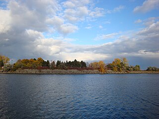
Rattray Marsh Conservation Area, is 94 acres of environmentally sensitive wetland situated along the shore of Lake Ontario in Canada. It is found on the west side of Jack Darling Memorial Park and is located in the city of Mississauga within the Regional Municipality of Peel. It is the last remaining lakefront marsh on the western end of Lake Ontario and is owned and managed by Credit Valley Conservation.

