Cresap's War

Last updated
Cresap's War
Cresapwarmap.png
Map showing the area disputed between Maryland and Pennsylvania during Cresap's War
Date1730–1767
Location
Pennsylvania–Maryland border
Result

Military stalemate

Belligerents
Commanders and leaders
Strength
militia militia

Cresap's War (also known as the Conojocular War, from the Conejohela Valley where it was mainly located along the south bank) was a border conflict between Pennsylvania and Maryland, fought in the 1730s. Hostilities erupted in 1730 with a series of violent incidents prompted by disputes over property rights and law enforcement, and escalated through the first half of the decade, culminating in the deployment of military forces by Maryland in 1736 and by Pennsylvania in 1737. The armed phase of the conflict ended in May 1738 with the intervention of King George II, who compelled the negotiation of a cease-fire. A final settlement was not achieved until 1767 when the Mason–Dixon line was recognized as the permanent boundary between the two colonies. [1]

Contents

Background

Pennsylvania's Charter (1681) specified that the colony was bounded "on the South by a Circle drawne at twelve miles [19 km] distance from New Castle Northward and Westward unto the beginning of the fortieth degree of Northern Latitude, and then by a streight Line Westward...." [2] Later surveys established that the town of New Castle in fact lay a full 25 miles (40 km) south of the fortieth parallel, setting the stage for a boundary dispute. Maryland insisted that the boundary be drawn at the fortieth parallel as specified in the Charter, while Pennsylvania proposed that it be drawn by an elaborate method which purported to compensate for the geographic misunderstanding on which the Charter had been based. This proposal placed the boundary near 39 36', creating a 28-mile (45 km) wide strip of disputed territory. [3]

Because the fortieth parallel lay north of the city of Philadelphia, Maryland pressed its claim most seriously in the sparsely inhabited lands west of the Susquehanna River. By the late 1710s, rumors had begun to reach the Pennsylvania Assembly that Maryland was planning to establish settlements in the disputed area near the river. In response, Pennsylvania attempted to bolster its claim to the territory by organizing a proprietorial manor along the Codorus Creek, just west of the river, in 1722. This action prompted a crisis in relations between the two colonies, leading to a royal proclamation in 1724 which prohibited both colonies from establishing new settlements in the area until a boundary had been surveyed. However, the two sides failed to reach agreement on the location of the boundary, and unauthorized settlement recommenced within a short time. [1]

Triggering violence

In 1726, the English-born Quaker leader John Wright and two associates with their families settled near the river. They had been coming to the birding swarms along the Conejohela Flats since 1724 and had made friends and converted an appreciable number of Indians, most by working their way through the marshy shallows on the opposite (west or right) bank of the Susquehanna. Sometime after building a house and planting a farm, probably with the help of their Indian friends in the second year there, Wright ended up building two medium-to-large dugout canoes kept and tied off on either bank, creating the seeds of an ad hoc passenger ferry business for those desiring to cross. A few settlers moved across, settling mainly a few miles to the north along Codorus Creek and Kreutz Creek, [4] but traffic grew sufficient to officially apply for a ferry license in 1730.[ citation needed ]

Settlement across picked up significantly that year, probably with the promise of regular ferry service across the Susquehanna, greatly easing transportation difficulties, but the inflow alarmed Lord Baltimore about his ability to assert control and collect incomes from the disputed area. By midsummer of 1730, a number of Pennsylvania Dutch settler families had crossed the river and taken up residence. [5] Determined to counter this development, a Marylander, Thomas Cresap, opened a second ferry service at Blue Rock, about four miles (6 km) south of Wright's Ferry near current day Washington Boro, Pennsylvania.[ citation needed ]

Owing to the royal proclamation of 1724, the Pennsylvania settlers did not have clear title to the lands that they occupied. Apparently in defiance of the proclamation, Maryland granted Cresap title to 500 acres (2 km2) along the west bank of the river, [6] much of which was already inhabited. Cresap began to act as a land agent, persuading many Pennsylvania Dutch to purchase their farms from him, thus obtaining title under Maryland law, and began collecting quit-rents (an early form of property tax) for Maryland. In response, Pennsylvania authorities at Wright's Ferry began to issue "tickets" to new settlers which, while not granting immediate title, promised to award title as soon as the area was officially opened to settlement. [7]

Outbreak of hostilities

Sometime in late October, 1730, Cresap was attacked on his ferry boat by two Pennsylvanians. [8] According to Cresap's Maryland deposition, Cresap and one of his workmen were hailed by the Pennsylvanians and began rowing the two men from the east to the west. Sixty yards into the trip, the Pennsylvanians turned their guns on the Marylanders and a fight ensued with Cresap attempting to use the oars to defend himself. After a short struggle, both Marylanders ended up in the water, holding on to the boat to keep from drowning. The Pennsylvanians tried to force Cresap to let go of the boat, and when Cresap asked if they intended to murder him, one swore that he did. Cresap eventually escaped when the boat drifted to shallow water near a large rock where Cresap was stranded for several hours until rescued by a friendly Indian.

It would become clear in later testimony that the target of the attack was actually Cresap's workman who was wanted by a Lancaster county landowner for reasons not entirely clear (possibly debts). This workman was captured by the Pennsylvanians and carried forcibly away.

Cresap was dissatisfied by the response of the Pennsylvania magistrate to whom he reported the attack. Although the magistrate eventually signed warrants that brought the two Pennsylvanians to court, he first stated that "he knew no reason he (Cresap) had to expect any justice there, since he was a liver in Maryland."; a statement that the Governor of Maryland would later key on in a letter to the Governor of Pennsylvania. Significantly, Cresap filed charges with Maryland authorities, claiming that Pennsylvania officials had conspired with the attackers and with local native tribes to drive him from the area. [9] From this point onward, Cresap would maintain that as a resident of Maryland, he was not bound by Pennsylvania law and was not obliged to cooperate with Pennsylvania's law enforcement officers.

1732 agreement

In 1732 the proprietary governor of Maryland, Charles Calvert, 5th Baron Baltimore, signed a provisional agreement with William Penn's sons, which drew a line somewhere in between and renounced the Calvert claim to Delaware. But later, Lord Baltimore claimed that the document he had signed did not contain the terms he had agreed to, and refused to put the agreement into effect. Beginning in the mid-1730s, violence erupted between settlers claiming various loyalties to Maryland and Pennsylvania. The border conflict would be known as Cresap's War.

The issue remained unresolved until 1760, when the Crown intervened, ordering Frederick Calvert, 6th Baron Baltimore to accept the 1732 agreement. Maryland's border with Delaware was to be based on the Transpeninsular Line and the Twelve-Mile Circle around New Castle. The Pennsylvania-Maryland border was defined as the line of latitude 15 miles south of the southernmost house in Philadelphia. [10]

Attempt to arrest Cresap

A witness named William Smith gave the following account about the attempted arrest of Cresap on January 29, 1733:

a Considerable number of People being at least Twenty in Number as he verily believes came in a Violent manner & required the Doors to be opened and the said Cresap to Surrender himself to them, one of them Swearing he was Sheriff of Lancaster County And others saying that they were to be Supported in their proceedings by one Emerson a Lawyer in Pensylvania [sic] and that they were then fifty Men & if they were not Enough they would have five hundred there next Morning to take Cresap. [11]

Cresap did not back down, claiming that "his house was his castle and he would defend it." [11] The crowd forced their way into the house, causing Cresap to fire a gun into the crowd. In response, "one or more of the said Persons several times said and Swore they would hang the said Cresap and burn his house & all that were in it." [11]

German farmers renounce Cresap

Depositions of several Germans accuse Cresap and his relatives, the Lowes, of maltreatment: [8]

Arrival of Maryland militia

Two incursions of Maryland militia into present day York County, Pennsylvania are mentioned in depositions by Pennsylvania natives: [8]

Arrival of Pennsylvania militia

Cresap first obtained a patent from Maryland for a ferry at Peach Bottom, near the Patterson farm, then shot several of Patterson's horses. One of the Marylanders, Lowe, was arrested and jailed, but the other Marylanders broke into the jail and freed him.

Cresap then obtained one for "Blue Rock Ferry" and several hundred acres of land, about 3½ miles south of Wrightsville, forcibly took possession of John Hendricks' plantation at Wrightsville. [12]

Cresap was no Quaker by any means; he had previously "cleft" an assailant in Virginia with a broad-ax when clearing disputed land there. [12]

Lord Baltimore had been unwilling to entreat with Indians for what he took, [12] but in 1733, reached an accommodation with the Pennsylvanians. By 1734, Cresap was again evicting settlers from their Lancaster and York county homes, rewarding his gang members with the properties. [12]

The sheriff of Lancaster County brought a posse to arrest Cresap, but when deputy Knowles Daunt was at the door, Cresap fired through it, wounding Daunt. The sheriff asked Mrs. Cresap for a candle, so that they could see to tend to Daunt's wounds, but Mrs. Cresap refused, "crying out that not only was she glad he had been hit, she would have preferred the wound had been to his heart." [12] When Daunt died, Pennsylvania Governor Gordon demanded that Maryland arrest Cresap for murder. Governor Ogle of Maryland responded by naming Cresap a captain in the Maryland militia. [12]

Cresap continued his raids, destroying barns and livestock, until Sheriff Samuel Smith raised a posse of 24 armed "non-Quakers" to arrest him on November 25, 1736. Unable to get him to surrender, they set his cabin on fire, and when he made a run for the river, they were upon him before he could launch a boat. He shoved one of his captors overboard, and cried, "Cresap's getting away", and the other deputies pummeled their peer with oars until the ruse was discovered. Removed to Lancaster, a blacksmith was fetched to put him in steel manacles, but Cresap knocked the blacksmith down in one blow. Once constrained in steel, he was hauled off to Philadelphia, and paraded through the streets before being imprisoned. His spirit unbroken, he announced, "Damn it, this is one of the prettiest towns in Maryland!" [12] [13]

Resolution

Following Cresap's arrest, Maryland sent a petition to King George II requesting that he intervene to restore order pending the outcome of the Chancery suit. On August 18, 1737, the king issued a proclamation instructing the governments of both colonies to cease hostilities. [14] Sporadic violence continued, prompting both sides to petition the king for further intervention. In response, the royal Committee for Plantation Affairs organized direct negotiations between the two colonies, which resulted in the signing of a peace agreement in London on May 25, 1738. This agreement provided for an exchange of prisoners and the drawing of a provisional boundary fifteen miles south of the city of Philadelphia. Each side agreed to respect the other's authority to conduct law enforcement and grant title to land on its own side of this boundary, pending the final action of the Chancery Court. [15]

Because Blue Rock Ferry lay well to the north of the provisional boundary, Cresap did not return to the area following his release in the prisoner exchange. In 1750, the Chancery Court upheld the validity of the 1732 agreement, which became the basis on which Charles Mason and Jeremiah Dixon surveyed the permanent boundary (the Mason–Dixon line) between Pennsylvania and Maryland in 1767. Today the conflict area is part of York County, Pennsylvania.

Cresap's son Michael played a prominent role in Lord Dunmore's War (1774). [12] For this reason some historians also refer to the 1774 conflict as "Cresap's War."[ citation needed ]

See also

Related Research Articles

<span class="mw-page-title-main">Lancaster County, Pennsylvania</span> County in Pennsylvania, United States

Lancaster County, sometimes nicknamed the Garden Spot of America or Pennsylvania Dutch Country, is a county in the Commonwealth of Pennsylvania. It is located in the south central part of Pennsylvania. As of the 2020 census, the population was 552,984, making it Pennsylvania's sixth-most populous county. Its county seat is Lancaster. Lancaster County comprises the Lancaster, Pennsylvania metropolitan statistical area.

<span class="mw-page-title-main">Columbia, Pennsylvania</span> Borough in Pennsylvania, United States

Columbia, formerly Wright's Ferry, is a borough (town) in Lancaster County, Pennsylvania, United States. As of the 2020 census, it had a population of 10,222. It is 28 miles (45 km) southeast of Harrisburg, on the east (left) bank of the Susquehanna River, across from Wrightsville and York County and just south of U.S. Route 30.

<span class="mw-page-title-main">York County, Pennsylvania</span> County in Pennsylvania, United States

York County is a county in the Commonwealth of Pennsylvania. As of the 2020 census, the population was 456,438. Its county seat is York. The county was created on August 19, 1749, from part of Lancaster County and named either after the Duke of York, an early patron of the Penn family, or for the city and county of York in England.

<span class="mw-page-title-main">Newberry Township, Pennsylvania</span> Township in Pennsylvania, United States

Newberry Township is a township in York County, Pennsylvania, United States. The population was 15,657 at the 2020 census.

<span class="mw-page-title-main">Wrightsville, Pennsylvania</span> Borough in Pennsylvania, United States

Wrightsville is a borough that is located in York County, Pennsylvania, United States. The population was 2,257 at the time of the 2020 census.

<span class="mw-page-title-main">Susquehanna River</span> Major river in the Northeastern United States

The Susquehanna River is a major river located in the Mid-Atlantic region of the United States, overlapping between the lower Northeast. At 444 miles (715 km) long, it is the longest river on the East Coast of the United States. By watershed area, it is the 16th-largest river in the United States, and also the longest river in the early 21st-century continental United States without commercial boat traffic.

<span class="mw-page-title-main">Province of Maryland</span> British colony in North America (1632–1776)

The Province of Maryland was an English and later British colony in North America that existed from 1632 until 1776, when it joined the other twelve of the Thirteen Colonies in rebellion against Great Britain and became the U.S. state of Maryland. Its first settlement and capital was St. Mary's City, in the southern end of St. Mary's County, which is a peninsula in the Chesapeake Bay and is also bordered by four tidal rivers.

<span class="mw-page-title-main">Charles Calvert, 5th Baron Baltimore</span> British noble

Charles Calvert, 5th Baron Baltimore, was a British nobleman and Proprietary Governor of the Province of Maryland. He inherited the title to Maryland aged just fifteen, on the death of his father and grandfather, when the colony was restored by the British monarchy to the Calvert family's control, following its seizure in 1688. In 1721 Charles came of age and assumed personal control of Maryland, travelling there briefly in 1732. For most of his life, he remained in England, where he pursued an active career in politics, rising to become Lord of the Admiralty from 1742 to 1744. He died in 1751 in England, aged 52.

<span class="mw-page-title-main">Samuel Ogle</span> Governor of colonial Maryland

Samuel Ogle was the 16th, 18th and 20th Proprietary Governor of Maryland from 1731 to 1732, 1733 to 1742, and 1746/1747 to 1752.

<span class="mw-page-title-main">Northern Central Railway</span> Railway connecting Baltimore MD and Sunbury PA, US

The Northern Central Railway (NCRY) was a Class I Railroad in the United States connecting Baltimore, Maryland, with Sunbury, Pennsylvania, along the Susquehanna River. Completed in 1858, the line came under the control of the Pennsylvania Railroad (PRR) in 1861, when the PRR acquired a controlling interest in the Northern Central's stock to compete with the rival Baltimore and Ohio Railroad (B&O).

Phineas Davis was a well-known clockmaker and inventor who designed and built the first practical American coal-burning railroad locomotive.

<span class="mw-page-title-main">Mason-Dixon Trail</span> A 199 mi. trail in the mid-Atlantic US states of Pennsylvania, Maryland, and Delaware

The Mason-Dixon Trail is a 193-mile (311 km) hiking trail that begins at the Appalachian Trail in south-central Pennsylvania, continues through northeastern Maryland and northern Delaware, and re-enters Pennsylvania shortly before ending at Chadds Ford. It is named for the historic Mason–Dixon line, which it crosses twice. About one-third of the route follows roads through rural areas, but the rest is on traditional footpaths. The trail also traverses many tracts of private land, at which passage for hikers has been arranged with owners. This results in occasional relocations. The trail takes hikers through a variety or rural and semi-urban landscapes, with most of the route in Pennsylvania featuring farmlands and forested areas, and most of the route in Maryland and Delaware featuring historic sites and small towns.

<span class="mw-page-title-main">Conrad Weiser Homestead</span> Historic house in Pennsylvania, United States

The Conrad Weiser Homestead was the home of Johann Conrad Weiser, who enlisted the Iroquois on the British side in the French and Indian War. The home is located near Womelsdorf, Berks County, Pennsylvania in the United States. A designated National Historic Landmark, it is currently administered as a historic house museum by the Pennsylvania Historical and Museum Commission. The historic site was established in 1923 to preserve an example of a colonial homestead and to honor Weiser, an important figure in the settlement of the colonial frontier.
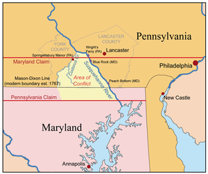
Colonel Thomas Cresap (c.1702—c.1790) was an English-born settler and trader in the states of Maryland and Pennsylvania. Cresap served Lord Baltimore as an agent in the Maryland–Pennsylvania boundary dispute that became known as Cresap's War. Later, together with the Native American chief Nemacolin, Cresap improved a Native American path to the Ohio Valley, and ultimately settled and became a large landowner near Cumberland, Maryland, where he was involved in further disputes near Brownsville, Pennsylvania, including in the French and Indian War and Lord Dunmore's War.

<span class="mw-page-title-main">Wright's Ferry</span>

Wright's Ferry was a Pennsylvania Colony settlement established by John Wright in 1726, that grew up around the site of an important Inn and Pub anchoring the eastern end of a popular animal powered ferry (1730–1901) and now a historic part of Columbia, Pennsylvania. The complex was important in settling the lands west of the cranky Susquehanna, for without resorting to water craft, the ferry was the first means of crossing the wide watercourse of the relatively shallow Susquehanna River for settlers with a cargo in the southern part of Pennsylvania—which is very wide from Middletown, Dauphin County southerly past Wright's Ferry and grows steadily wider as it nears its mouth at the Chesapeake Bay, and whose banks are steep enough to prevent easy cargo handling from small boats.

<span class="mw-page-title-main">Codorus Navigation</span>

The Codorus Navigation Company, based in York in south-central Pennsylvania, was formed in 1829 to make a navigable waterway along Codorus Creek from York, Pennsylvania, to the Susquehanna River, a distance of 11 miles (18 km). Plans called for 3 miles (4.8 km) of canal, 8 miles (12.9 km) of slack-water pools, 10 dams, and 13 locks with an average lift of about 7 feet (2.1 m).

John Wright was an emigrant English pioneer, colonial period businessman who established Wright's Ferry. The resulting increase in settlement triggered nine years of armed conflict during the Maryland-Pennsylvania boundary dispute known as Cresap's War. The animal powered ferry was the very first means of crossing the broad unfriendly Susquehanna River in a region known as Conejohela Valley nearly halfway between what became Lancaster County, Pennsylvania, and York County, Pennsylvania.

The Conejohela Flats are a group of islands in the flooded Conejohela Valley, a large floodplain along the southernmost 30 miles (50 km) of the Susquehanna River in Pennsylvania and Maryland in the United States. The valley was flooded primarily during the early 1900s by the construction of the Holtwood, Conowingo, and Safe Harbor dams from 1910 to 1931.

<span class="mw-page-title-main">Dritt Mansion</span> Historic house in Pennsylvania, United States

Dritt Mansion, named after its longest occupants, and also called Pleasant Garden, and current home to the Zimmerman Center for Heritage, is a historic home located at Lower Windsor Township, York County, Pennsylvania. It was built about 1758, and is a 2+12-story, fieldstone dwelling. It measures 50 feet (15.2 m) long and 40 (12.2 m) feet wide, with a cedar-shingled gable roof. The house has remained virtually unchanged since its construction. The land the house is on was first granted by Lord Baltimore to Thomas Cresap in 1729, who operated a ferry here and claimed the area for Maryland. Cresap was arrested in 1736 and driven away after skirmishes known as "Cresap's War"—a dispute finally resolved in 1784 when the Mason–Dixon line was established. Today the home plays host to Heritage Area offices and programs and the Visions of the Susquehanna River Art Collection.

<span class="mw-page-title-main">Penn–Calvert boundary dispute</span> Long-running legal conflict

The Penn–Calvert boundary dispute was a long-running legal conflict between William Penn and his heirs on one side, and Charles Calvert, 3rd Baron Baltimore and his heirs on the other side. The overlapping nature of their charters of land in Colonial America required numerous attempts at mediation, surveying, and intervention by the king and courts of England to ultimately be resolved. Subsequent questions over these charters have also been adjudicated by American arbitrators and the Supreme Court of the United States. The boundary dispute shaped the eventual borders of five U.S. states: Pennsylvania, Maryland, Delaware, New Jersey, and West Virginia.

References

  1. 1 2 Paul Doutrich (1986). "Cresap's War: Expansion and Conflict in the Susquehanna Valley". Pennsylvania History. Cip.cornell.edu. 53: 89–104.
  2. "The Avalon Project: Documents in Law, History and Diplomacy". Yale.edu. Archived from the original on 2015-04-05. Retrieved 2015-05-21.
  3. "The Boundary Disputes of Colonial Maryland". Chriswhong.com. Retrieved 2015-05-21.
  4. Gibson, John, ed. (1886). History of York County Pennsylvania From the Earliest Time to the Present. Chicago: F.A. Battey Publishing Co. p.  13 . Retrieved 11 February 2019.
  5. "1700–1749 – The York Daily Record". Ydr.com. Retrieved 2015-05-21.
  6. Kenneth P. Bailey, Thomas Cresap: Maryland Frontiersman, Cristopher Publishing, 1944, p. 32.
  7. Franklin Ellis and Samuel Evans, History of Lancaster County, Pennsylvania, Everts & Peck, 1883.
  8. 1 2 3 Pennsylvania Archives Series 1 Vol 1, By Samuel Hazard, William Henry Egle, Pennsylvania Dept. of Public Instruction, 1852, pp. 311–313, 352–367, 412–421, 462–468, 476, 487, 489–494, 499–535
  9. Kenneth P. Bailey, Thomas Cresap: Maryland Frontiersman, Cristopher Publishing, 1944, pp. 32–36.
  10. Hubbard, Bill Jr. (2009). American Boundaries: the Nation, the States, the Rectangular Survey . University of Chicago Press. pp.  20–23. ISBN   978-0-226-35591-7.
  11. 1 2 3 "Archives of Maryland, Volume 0028, p. 0062 – Proceedings of the Council of Maryland, 1732:1753". Aomol.msa.maryland.gov. 2014-10-31. Retrieved 2015-05-21.
  12. 1 2 3 4 5 6 7 8 John Gibson, ed., History of York County, Pennsylvania, F.A. Battey Publishing Co., 1886. pp. 602–604.
  13. Gibson, John (1886). History of York County Pennsylvania From the Earliest Time to the Present. Schmidt Library York College of Pennsylvania. F.A. Battey Publishing Co., Chicago. pp.  67.
  14. Proceedings of the Council of Maryland 28 (1732–1753), pp. 130–133.
  15. Proceedings of the Council of Maryland 28 (1732–1753), pp. 145–149.