Wrightsville, Pennsylvania

Last updated
Wrightsville, Pennsylvania
Wrights Ferry
Borough
Wrightsville PA HD Presby.JPG
York County Pennsylvania incorporated and unincorporated areas Wrightsville highlighted.svg
Location in York County and the U.S. state of Pennsylvania.
USA Pennsylvania location map.svg
Red pog.svg
Wrightsville
Location of Wrightsville in Pennsylvania
Usa edcp location map.svg
Red pog.svg
Wrightsville
Wrightsville (the United States)
Coordinates: 40°01′28″N76°31′52″W / 40.02444°N 76.53111°W / 40.02444; -76.53111
Country United States
State Pennsylvania
County York
Settled1811 (1811)
Incorporated1834
Government
  TypeBorough Council
  MayorMichael Albert
  Council PresidentEric J White
Area
[1]
  Total0.66 sq mi (1.70 km2)
  Land0.66 sq mi (1.70 km2)
  Water0.00 sq mi (0.00 km2)
Elevation
390 ft (120 m)
Population
 (2020) [2]
  Total2,257 Decrease2.svg
  Estimate 
(2019) [2]
2,249
  Density3,505.34/sq mi (1,352.54/km2)
Time zone UTC-5 (Eastern (EST))
  Summer (DST) UTC-4 (EDT)
Zip code
17368
Area code 717
FIPS code 42-86640
Website www.wrightsvilleborough.com

Wrightsville is a borough that is located in York County, Pennsylvania, United States. The population was 2,257 at the time of the 2020 census. [2]

Contents

Wrightsville borough has a police department, historic society and a volunteer fire company.

History

Columbia-Wrightsville Bridge in 2014 (foreground) Bridge to wrightsville, pa.jpg
Columbia-Wrightsville Bridge in 2014 (foreground)

According to a plaque at Samuel S. Lewis State Park, which overlooks Wrightsville and the Susquehanna River, Wrightsville was among George Washington's choices as the location of the capital of the United States.

The world's longest covered bridge, at 5,600 feet (1,700 m), once spanned the Susquehanna from Wrightsville to neighboring Columbia in Lancaster County. Built in 1814, it was destroyed by high water and ice in 1832. A replacement bridge was burned the night of June 28, 1863, by state militia during the Gettysburg Campaign in the American Civil War. Confederate troops under John Brown Gordon formed a bucket brigade to save the town from fire. Yet another replacement covered bridge was destroyed by a windstorm a few years later.

The final bridge, the Pennsylvania Railroad Bridge, was a steel open-air bridge constructed in 1896. It was razed in the early 1960s because of obsolescence and restructuring of the railroad industry. The site of the former bridge is now home of a concrete bridge known as Wright’s Ferry Bridge. The bridge standing today is approximately 100 yards north of the original bridge location [3]

Wrightsville was the northern terminus of the Susquehanna and Tidewater Canal, which extended to Havre de Grace, Maryland.

In 2007, Wrightsville was the chosen location for the rekindling of the War of the Roses between the York Revolution and the Lancaster Barnstormers baseball teams. Wrightsville was chosen for its location on the Susquehanna River, the boundary between York and Lancaster counties.

The Columbia-Wrightsville Bridge and Wrightsville Historic District are listed on the National Register of Historic Places. [4]

Geography

Wrightsville is located at 40°1′28″N76°31′52″W / 40.02444°N 76.53111°W / 40.02444; -76.53111 (40.024481, -76.531221). [5]

According to the United States Census Bureau, the borough has a total area of 0.6 square miles (1.6 km2), all land.

Demographics

Historical population
CensusPop.Note
1840 672
1850 1,31094.9%
1860 1,3603.8%
1870 1,54413.5%
1880 1,77615.0%
1890 1,9127.7%
1900 2,26618.5%
1910 2,051−9.5%
1920 1,943−5.3%
1930 2,24715.6%
1940 2,120−5.7%
1950 2,104−0.8%
1960 2,34511.5%
1970 2,66813.8%
1980 2,365−11.4%
1990 2,3961.3%
2000 2,223−7.2%
2010 2,3103.9%
2020 2,257−2.3%
2021 (est.)2,249 [2] −0.4%
Sources: [6] [7] [8]

As of the census [7] of 2000, there were 2,223 people, 955 households, and 606 families residing in the borough. The population density was 3,572.8 inhabitants per square mile (1,379.5/km2). There were 1,009 housing units at an average density of 1,621.7 per square mile (626.1/km2). The racial makeup of the borough was 97.62% White, 0.40% African American, 0.09% Native American, 0.36% Asian, 0.54% from other races, and 0.99% from two or more races. Hispanic or Latino of any race were 2.02% of the population.

There were 955 households, out of which 29.7% had children under the age of 18 living with them, 46.1% were married couples living together, 11.1% had a female householder with no husband present, and 36.5% were non-families. 30.6% of all households were made up of individuals, and 11.4% had someone living alone who was 65 years of age or older. The average household size was 2.33 and the average family size was 2.86.

In the borough, the population was spread out, with 23.1% under the age of 18, 7.6% from 18 to 24, 31.4% from 25 to 44, 22.7% from 45 to 64, and 15.2% who were 65 years of age or older. The median age was 38 years. For every 100 females, there were 94.8 males. For every 100 females age 18 and over, there were 92.0 males.

The median income for a household in the borough was $37,379, and the median income for a family was $47,083. Males had a median income of $33,587 versus $23,073 for females. The per capita income for the borough was $18,711. About 4.9% of families and 5.8% of the population were below the poverty line, including 4.8% of those under age 18 and 10.6% of those age 65 or over.

Politics

National

Wrightsville is district PA-11 in the United States House of Representatives. PA-11's current representative is Republican Lloyd Smucker. He assumed office on January 3, 2017.

State and Local

Wrightsville is District 28 in the Pennsylvania State Senate. PA-28's current senator is Republican Kristin Phillips-Hill, who assumed office in 2019. Before being elected she served in the Pennsylvania House from 2015 to 2018.

Wrightsville is District 47 in the Pennsylvania State House of Representatives. PA-47 is currently represented by Republican Joe D'Orsie. Before he was in politics, Gillespie was communications director at Praise Community Church in Spring Garden Township.

Emergency Services

Fire Department

Although fire protection in Wrightsville Borough can be traced back to the early 1800s, it wasn't until 1887 that the Wrightsville Steam Fire Engine and Hose Company #1 (York County Station 41) was organized. The fire department protects nearly 10,000 citizens in Wrightsville Borough and Hellam Township with an all-volunteer staffing of over 30 active firefighters, as well as a support staff and a junior firefighter program (ages 14–17).

The Wrightsville Fire Department has been recognized by the Commonwealth of Pennsylvania after meeting or exceeding the requirements set forth in the Voluntary Rescue Service Recognition Program. The Wrightsville Fire Department was also a participating department with the Commonwealth's professional certification program in which over 95% of its members are trained to the National Proboard Firefighter 1 & 2 certification levels. In 2019, the department responded to a total of 771 calls for service. [9]

The department is located at 125 South Second Street in Wrightsville Borough. The current facility was completed in 1979, and houses four pieces of fire apparatus: a 1996 Seagrave rescue/pumper (Rescue 41–1), a 2005 Seagrave pumper (Engine 41), a 2005 Ford 550/Semo rescue (Rescue 41–2), and an 2018 Inmar inflatable rescue boat (Boat 41).

Medical Services

Aside from fire/rescue services, Station 41 provides Quick Response Services (QRS) to residents in Wrightsville Borough and Hellam Township. This includes basic emergency medical care provided by Emergency Medical Technicians and Emergency Medical Responders until transporting EMS units arrive. The average response time for QRS calls was one minute in 2014.

Basic life support (BLS), Advance life support (ALS), and transport coverage is contracted with Lancaster County-based Susquehanna Valley EMS (SVEMS) but respond from the Hellam Township Municipal Building as Ambulance 41. Basic life support services were previously provided by White Rose Ambulance, but ended service on June 1, 2017, after local municipal officials and White Rose Ambulance could not reach an agreement to renew the contract. Although they share the same station number as the Wrightsville Fire Department, there is no affiliation.

Police

Wrightsville was protected by its own police force until July 1, 2018, when it was merged with nearby stations. Wrightsville Borough is currently protected by the Hellam Township Police Department.

Education

Wrightsville is served by the Eastern York School District. [10]

Related Research Articles

<span class="mw-page-title-main">Akron, Pennsylvania</span> Borough in Pennsylvania, United States

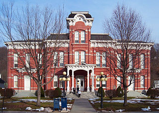
Akron is a borough in Lancaster County, Pennsylvania, United States. As of the 2020 census, it had a population of 4,169,

<span class="mw-page-title-main">Columbia, Pennsylvania</span> Borough in Pennsylvania, United States

Columbia, formerly Wright's Ferry, is a borough (town) in Lancaster County, Pennsylvania, United States. As of the 2020 census, it had a population of 10,222. It is 28 miles (45 km) southeast of Harrisburg, on the east (left) bank of the Susquehanna River, across from Wrightsville and York County and just south of U.S. Route 30.

<span class="mw-page-title-main">Marietta, Pennsylvania</span> Borough in Pennsylvania, United States

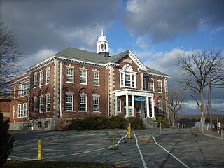
Marietta is a borough in Lancaster County, Pennsylvania, United States. The population was 2,633 at the 2020 census. It is located on the east bank of the Susquehanna River, northwest of Columbia.

<span class="mw-page-title-main">Wayne County, Pennsylvania</span> County in Pennsylvania

Wayne is a county in the Commonwealth of Pennsylvania. It is part of Northeastern Pennsylvania. The county's population was 51,155 at the 2020 census. The county seat is the Borough of Honesdale. The county was formed from part of Northampton County on March 21, 1798, and was named for the Revolutionary War General Anthony Wayne.

<span class="mw-page-title-main">Gap, Pennsylvania</span> Census-designated place in Pennsylvania, United States

Gap is a census-designated place (CDP) and unincorporated community in Salisbury Township, Lancaster County, Pennsylvania, United States, with a ZIP code of 17527. The population was 1,931 at the 2010 census. U.S. Route 30 passes through the town, which is also the terminus for four Pennsylvania highways: 772, 741, 897, and the heavily used 41, which leads toward Wilmington, Delaware.

<span class="mw-page-title-main">Mountville, Pennsylvania</span> Borough in Pennsylvania, United States

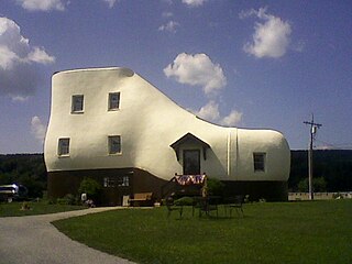
Mountville is a borough in Lancaster County, Pennsylvania, United States. The population was 3,022 at the 2020 census, an increase over the figure of 2,802 tabulated in 2010. The original Charles Chips potato chip factory was located here.

<span class="mw-page-title-main">West Hempfield Township, Pennsylvania</span> Township in Pennsylvania, United States

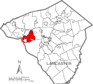
West Hempfield Township is a township in west central Lancaster County, Pennsylvania, United States. The population was 17,061 at the 2020 census.

<span class="mw-page-title-main">Hanover Township, Luzerne County, Pennsylvania</span> Township in Pennsylvania, United States

Hanover Township is a township in Luzerne County, Pennsylvania. As of the 2020 census, the population was 11,424, making it the most populous township in the county.

<span class="mw-page-title-main">Plymouth Township, Luzerne County, Pennsylvania</span> Township in Pennsylvania, United States

Plymouth Township is located in Luzerne County, Pennsylvania, United States. The population was 1,712 at the 2020 census.

<span class="mw-page-title-main">Wyoming, Pennsylvania</span> Borough in Luzerne County, Pennsylvania, US

Wyoming is a borough in the Greater Pittston area of Luzerne County, Pennsylvania, United States. It is located 5 miles (8 km) north of Wilkes-Barre, along the Susquehanna River. The population was 3,097 as of the 2020 census.

<span class="mw-page-title-main">Perry Township, Snyder County, Pennsylvania</span> Township in Pennsylvania, United States

Perry Township is a township in Snyder County, Pennsylvania, United States. As of the 2020 census, the township population was 2,062.

<span class="mw-page-title-main">Susquehanna Depot, Pennsylvania</span> Borough in Pennsylvania, United States

Susquehanna Depot, often referred to simply as Susquehanna, is a borough in Susquehanna County, Pennsylvania, United States, located on the Susquehanna River 23 miles (37 km) southeast of Binghamton, New York. In the past, railroad locomotives and railroad cars were made here. It is also known for its Pennsylvania Bluestone quarries.

<span class="mw-page-title-main">Thompson, Pennsylvania</span> Borough in Pennsylvania, United States

Thompson is a borough in Susquehanna County, Pennsylvania, United States. The population was 255 at the 2020 census.

<span class="mw-page-title-main">Hallam, Pennsylvania</span> Borough in Pennsylvania, United States

HallamHEL-əm is a borough in York County, Pennsylvania, United States. The population was 2,774 at the 2020 census.

<span class="mw-page-title-main">Hellam Township, York County, Pennsylvania</span> Township in Pennsylvania, United States

Hellam Township is a township in York County, Pennsylvania, United States. The population was 5,921 at the 2020 census. Founded in 1739, it was the first township in the area, and it originally included the entirety of modern York and Adams counties. Fire department services are provided jointly by the Hallam and Wrightsville fire departments, located in the boroughs of Hallam and Wrightsville.

<span class="mw-page-title-main">Jacobus, Pennsylvania</span> Borough in Pennsylvania, United States

Jacobus is a borough which is located in York County, Pennsylvania, United States. The population was 1,829 at the time of the 2020 census. The Borough is a suburb in the York area and is about 6 miles south of downtown York, PA.

<span class="mw-page-title-main">Springettsbury Township, Pennsylvania</span> Township in Pennsylvania, United States

Springettsbury Township is a township in York County, Pennsylvania, United States. The population was 27,058 at the 2010 census. The township takes its name from Springett Penn, grandson of Pennsylvania founder William Penn. Located east and northeast of the city of York, the township hosts the York Galleria shopping mall and a large Harley-Davidson manufacturing plant.

<span class="mw-page-title-main">Windsor Township, York County, Pennsylvania</span> Township in Pennsylvania, United States

Windsor Township is a township in York County, Pennsylvania, United States. The population was 17,839 at the 2020 census.

<span class="mw-page-title-main">Pennsylvania Route 624</span> State highway in York County, Pennsylvania, US

Pennsylvania Route 624 is a north–south state route located in southern central Pennsylvania. Its southern terminus is at PA 24 in Red Lion. The northern terminus is at PA 462 in Wrightsville near the Columbia–Wrightsville Bridge that carries PA 462 across the Susquehanna River. PA 624 is a two-lane undivided road that runs through rural areas in eastern York County. The route heads northeast from Red Lion and passes through Windsor before it comes to an intersection with PA 124 and PA 425 in Craley. PA 624 continues northeast before it turns north and follows the western bank of the Susquehanna River to Wrightsville. PA 224 was originally designated in 1928 to run from Red Lion north to U.S. Route 30 in Wrightsville. The route was extended south to PA 24/PA 74 in Red Lion by 1930. In the 1930s, PA 224 was renumbered to PA 624 to avoid confusion with US 224. The south end of PA 624 was moved to its current location in the 1960s following a rerouting of PA 24.

<span class="mw-page-title-main">Washington Boro, Pennsylvania</span> Census-designated place in Pennsylvania, United States

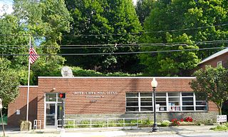
Washington Boro is an unincorporated community and census-designated place (CDP) in Manor Township, Lancaster County, Pennsylvania, United States, along the Susquehanna River. The ZIP code is 17582. It is served by the Penn Manor School District and is the terminus of Pennsylvania Route 441 and Pennsylvania Route 999. As of the 2010 census, the population was 729.

References

  1. "2019 U.S. Gazetteer Files". United States Census Bureau. Retrieved July 28, 2020.
  2. 1 2 3 4 Bureau, US Census. "City and Town Population Totals: 2020-2021". Census.gov. US Census Bureau. Retrieved 9 July 2022.
  3. "RiverRoots: Bridging the Susquehanna". Susquehanna NHA. 2020-04-20. Retrieved 2023-01-04.
  4. "National Register Information System". National Register of Historic Places . National Park Service. July 9, 2010.
  5. "US Gazetteer files: 2010, 2000, and 1990". United States Census Bureau. 2011-02-12. Retrieved 2011-04-23.
  6. "Census of Population and Housing". U.S. Census Bureau. Retrieved 11 December 2013.
  7. 1 2 "U.S. Census website". United States Census Bureau . Retrieved 2008-01-31.
  8. "Incorporated Places and Minor Civil Divisions Datasets: Subcounty Resident Population Estimates: April 1, 2010 to July 1, 2012". Population Estimates. U.S. Census Bureau. Retrieved 11 December 2013.
  9. "Wrightsville Fire & Rescue Company". wrightsvillefire.com. Retrieved 2020-09-25.
  10. National Center for Education Statistics, Common Core of Data - Eastern York School District, 2012

Further reading