New Freedom, Pennsylvania

Last updated

New Freedom
Borough
New Freedom PA.JPG
Former Pennsylvania Railroad Station, now a restaurant and museum on the York County Heritage Rail Trail County Park
York County Pennsylvania incorporated and unincorporated areas New Freedom highlighted.svg
Location in York County and the U.S. state of Pennsylvania.
USA Pennsylvania location map.svg
Red pog.svg
New Freedom
Location of New Freedom in Pennsylvania
Usa edcp location map.svg
Red pog.svg
New Freedom
New Freedom (the United States)
Coordinates: 39°44′12″N76°41′55″W / 39.73667°N 76.69861°W / 39.73667; -76.69861
Country United States
State Pennsylvania
County York
Settled1783
Incorporated1879
Government
  TypeBorough Council
  MayorKim Butcher
Area
[1]
  Total2.08 sq mi (5.39 km2)
  Land2.08 sq mi (5.39 km2)
  Water0.00 sq mi (0.00 km2)
Elevation
643 ft (196 m)
Population
 (2020) [2]
  Total4,877
  Density2,343.58/sq mi (905.06/km2)
Time zone UTC-5 (Eastern (EST))
  Summer (DST) UTC-4 (EDT)
ZIP code
17349
Area code 717
FIPS code 42-53568
Website New Freedom

New Freedom is a borough in York County, Pennsylvania, United States. As of the 2020 census, the borough had a population of 4,874. [3] Once an industrial/railroad town, the community has evolved into a predominantly residential community.

Contents

History

New Freedom Borough is located in the southern portion of York County, Pennsylvania. The borough borders the Mason-Dixon line and was incorporated in 1873. Originally named “Freedom” for the Free family, there was another town already in existence with that name, so New Freedom was chosen as the official name. [4]

People of German, English, and Scotch-Irish descent settled the area. The rich, fertile soil provided a comfortable living for farming and agricultural opportunities. Summers Canning Company operated in the town for years, canning the freshest harvests and then shipping the final products. Summers Canning Company was sold to Hanover Foods in 1984. [5] A mural depicting scenes from the Summers Canning Company is displayed on a building along the York County Heritage Rail Trail.

The Northern Central Railway was a primary factor for early growth of the town. The rail service established a vital means of commerce and transportation until Hurricane Agnes in 1972 destroyed much of the rail line and bridges in York County.

Located 30 miles north of Baltimore, Maryland and 38 miles south of Harrisburg, Pennsylvania, the town is changing from an area of commerce and minor industry to a commuter community.

Geography

New Freedom is located at 39°44′12″N76°41′55″W / 39.73667°N 76.69861°W / 39.73667; -76.69861 (39.736703, −76.698541). [6]

According to the United States Census Bureau, the borough has a total area of 2.0 square miles (5.2 km2), all land.

Demographics

Historical population
CensusPop.Note
1880 324
1890 36412.3%
1900 55051.1%
1910 72632.0%
1920 90624.8%
1930 1,12524.2%
1940 1,1371.1%
1950 1,27111.8%
1960 1,3959.8%
1970 1,4957.2%
1980 2,20547.5%
1990 2,92032.4%
2000 3,51220.3%
2010 4,46427.1%
2020 4,8749.2%
2021 (est.)5,090 [3] 4.4%
Sources: [7] [8] [9] [2]

As of the census [8] of 2000, there were 3,512 people, 1,296 households, and 1,031 families residing in the borough. The population density was 1,711.8 people per square mile (660.9 people/km2). There were 1,340 housing units at an average density of 653.1 per square mile (252.2/km2). The racial makeup of the borough was 96.53% White, 0.77% African American, 0.14% Native American, 1.40% Asian, 0.03% Pacific Islander, 0.09% from other races, and 1.05% from two or more races. Hispanic or Latino of any race were 0.48% of the population.

There were 1,296 households, out of which 38.4% had children under the age of 18 living with them, 70.1% were married couples living together, 7.1% had a female householder with no spouse present, and 20.4% were non-families. 16.9% of all households were made up of individuals, and 7.3% had someone living alone who was 65 years of age or older. The average household size was 2.70 and the average family size was 3.04.

In the borough the population was spread out, with 26.2% under the age of 18, 5.8% from 18 to 24, 29.0% from 25 to 44, 27.8% from 45 to 64, and 11.3% who were 65 years of age or older. The median age was 40 years. For every 100 females there were 94.9 males. For every 100 females age 18 and over, there were 93.8 males.

The median income for a household in the borough was $66,458, and the median income for a family was $70,319. Males had a median income of $46,563 versus $31,576 for females. The per capita income for the borough was $24,828. About 1.3% of families and 2.7% of the population were below the poverty line, including 1.3% of those under age 18 and 11.7% of those age 65 or over.

Community

Section of the York County Heritage Rail Trail that runs through New Freedom. York County Heritage Rail Trail, New Freedom, 2009.jpg
Section of the York County Heritage Rail Trail that runs through New Freedom.

The York County Heritage Rail Trail cuts through the center of New Freedom. The trail, which was established in 1992, runs from just south of New Freedom 21 miles (34 km) north into the city of York. The trail also connects to 20-mile-long (32 km) Northern Central Railroad Trail in Maryland, heading south from the Mason-Dixon line.

Popular seasonal events in New Freedom include:

A community park in the middle of town is known as the "Freedom Green".

The Leviathan, a replica of Abraham Lincoln's funeral train, in New Freedom Lincoln Funeral Train replica.JPG
The Leviathan, a replica of Abraham Lincoln's funeral train, in New Freedom

New Freedom teens attend Susquehannock High School and Southern Middle School, part of Pennsylvania's Southern York County School District, as well as private schools including Shrewsbury Christian Academy, York Catholic High School, or York Country Day School. In 2010, St. John the Baptist opened a new Roman Catholic Parochial School in the New Freedom borough.

New Freedom is home to the D. Landreth Seed Company, which is the oldest seed company in America. [10]

Notable people

Related Research Articles

<span class="mw-page-title-main">Akron, Pennsylvania</span> Borough in Pennsylvania, United States

Akron is a borough in Lancaster County, Pennsylvania, United States. As of the 2020 census, it had a population of 4,169,

<span class="mw-page-title-main">Littlestown, Pennsylvania</span> Borough in Pennsylvania, United States

Littlestown is a borough in Adams County, Pennsylvania, United States. The population was 4,782 at the 2020 census.

<span class="mw-page-title-main">Clairton, Pennsylvania</span> Place in Pennsylvania, United States

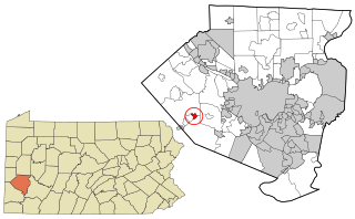
Clairton is a city in Allegheny County, Pennsylvania, United States. It is located along the Monongahela River and is part of the Pittsburgh Metropolitan Area. The population was 6,181 at the 2020 census. Under Pennsylvania legal classifications for local governments, Clairton is considered a third-class city. It is home to Clairton Works, the largest coke manufacturing facility in the United States.

<span class="mw-page-title-main">Oakdale, Pennsylvania</span> Borough in Pennsylvania, United States

Oakdale is a borough in Allegheny County, Pennsylvania, United States and is a Pittsburgh suburb. The population was 1,475 at the 2020 census. Its zip code is 15071.

<span class="mw-page-title-main">Ford City, Pennsylvania</span> Borough in Pennsylvania, United States

Ford City is a borough in Armstrong County, Pennsylvania, United States, 40 miles (64 km) northeast of Pittsburgh along the east bank of the Allegheny River and 4 miles (6 km) south of Kittanning, the county seat. The population was 2,859 at the 2020 census. It is part of the Pittsburgh metropolitan area.

<span class="mw-page-title-main">Robesonia, Pennsylvania</span> Borough in Pennsylvania, United States

Robesonia is a borough in Berks County, Pennsylvania, United States. The population was 2,061 at the 2010 census. Once famous for its iron furnaces, the town was founded in 1855 by Henry P. Robeson, who had acquired existing iron manufacturing operations and founded the Robesonia Iron Company in 1845. The town is now supported by large industry. Several of the largest employers include C&S Wholesale Grocers, a food distributor, Magnatech International, and Snap-On Tools. The town is also known for its Pennsylvania German-style pottery, also sometimes called redware. The Robesonia area is served by the Conrad Weiser Area School District and Conrad Weiser High School.

<span class="mw-page-title-main">Newtown, Bucks County, Pennsylvania</span> Borough in Pennsylvania, United States

Newtown is a borough in Bucks County, Pennsylvania, United States. The population was 2,268 at the 2020 census. It is located just west of the Trenton, New Jersey metropolitan area, and is part of the larger Philadelphia metropolitan area. It is entirely surrounded by Newtown Township, from which it separated in 1838. State Street is the main commercial thoroughfare with wide sidewalks, shops, taverns, and restaurants.

<span class="mw-page-title-main">Vintondale, Pennsylvania</span> Borough in Pennsylvania, United States

Vintondale is a borough in Cambria County, Pennsylvania, United States. It is part of the Johnstown, Pennsylvania Metropolitan Statistical Area. The population was 414 as of the 2010 census.

<span class="mw-page-title-main">New Bethlehem, Pennsylvania</span> Borough in Pennsylvania, United States

New Bethlehem is a borough in Clarion County, Pennsylvania, United States. The population was 979 at the 2020 census. The borough is situated at the southwestern corner of the Pennsylvania Wilds Conservation Landscape. Its main street, PA Route 28-66, is a major thoroughfare between the Pittsburgh metropolitan region and northcentral Pennsylvania.

<span class="mw-page-title-main">Ridgway, Pennsylvania</span> Borough in Pennsylvania, United States

Ridgway is a borough in and the county seat of Elk County, Pennsylvania. As of the 2020 census it had a population of 4,039

<span class="mw-page-title-main">Duryea, Pennsylvania</span> Borough in Pennsylvania, United States

Duryea is a borough in the Greater Pittston area of Luzerne County, Pennsylvania, United States, 9 miles (14 km) south of Scranton. The Susquehanna River marks Duryea's western boundary and the Lackawanna River flows through Duryea. It was incorporated as a borough in 1901, and had a notable switching rail yard, the Duryea yard, connecting the central Wyoming Valley to destinations in lower New York and down-state Pennsylvania. Coal mining and silk manufacturing were the chief industries in Duryea's early years. The population was 5,032 at the 2020 census.

<span class="mw-page-title-main">Conshohocken, Pennsylvania</span> Borough in Pennsylvania, United States

Conshohocken is a borough on the Schuylkill River in Montgomery County, Pennsylvania in suburban Philadelphia. Historically a large mill town and industrial and manufacturing center, after the decline of industry in recent years Conshohocken has developed into a center of riverfront commercial and residential development. In the regional slang, it is sometimes referred to by the colloquial nickname Conshy.

<span class="mw-page-title-main">Danville, Pennsylvania</span> Borough in Pennsylvania, United States

Danville is a borough in and the county seat of Montour County, Pennsylvania, United States, along the North Branch of the Susquehanna River. The population was 4,221 at the 2020 census.

<span class="mw-page-title-main">Hellertown, Pennsylvania</span> Place in Pennsylvania, United States

Hellertown is a borough in Northampton County, Pennsylvania. Its population was 6,131 at the 2020 census. Hellertown is part of the Lehigh Valley metropolitan area, which had a population of 861,899 and was the 68th-most populous metropolitan area in the U.S. as of 2020.

<span class="mw-page-title-main">Orwigsburg, Pennsylvania</span> Borough in Pennsylvania, United States

Orwigsburg is a borough in Schuylkill County, Pennsylvania. The borough was named for its founder, Peter Orwig, and created from West Brunswick Township in 1823.

<span class="mw-page-title-main">Montrose, Pennsylvania</span> Borough in Pennsylvania, United States

Montrose is a borough in Susquehanna County, Pennsylvania, United States, 18.41 miles (29.63 km) south-southeast of Binghamton, New York and 31.39 miles (50.52 km) north by west of Scranton. The land is elevated approximately 1,400 feet (430 m) above sea level. It is the Susquehanna County seat.

<span class="mw-page-title-main">Smithton, Pennsylvania</span> Borough in Pennsylvania, United States

Smithton is a borough in Westmoreland County, Pennsylvania, United States. The population was 399 at the 2010 census. As of 2018, the population was listed at 378. Smithton has its own post office, with zip code 15479, and is serviced by Yough School District.

<span class="mw-page-title-main">Dillsburg, Pennsylvania</span> Borough in Pennsylvania, United States

Dillsburg is a borough in York County, Pennsylvania, United States. The population was 2,643 as of the 2020 census.

<span class="mw-page-title-main">Glen Rock, Pennsylvania</span> Borough in Pennsylvania, United States

Glen Rock is a borough in York County, Pennsylvania, United States. The population was 2,120 at the 2020 census.

<span class="mw-page-title-main">Shrewsbury, Pennsylvania</span> Borough in Pennsylvania, United States

Shrewsbury is a borough in York County, Pennsylvania, United States. The population was 3,848 at the time of the 2020 census.

References

  1. "ArcGIS REST Services Directory". United States Census Bureau. Retrieved October 12, 2022.
  2. 1 2 "Census Population API". United States Census Bureau. Retrieved October 12, 2022.
  3. 1 2 Bureau, US Census. "City and Town Population Totals: 2020-2021". Census.gov. US Census Bureau. Retrieved July 9, 2022.
  4. New Freedom Heritage Foundation, Compiled Video Exhibition on the History of New Freedom. 2010, New Freedom Museum.
  5. https://bwsummers.wordpress.com/2013/12/10/summers-one-hundred-years/ Additional history of the Summers family and canning company.
  6. "US Gazetteer files: 2010, 2000, and 1990". United States Census Bureau. February 12, 2011. Retrieved April 23, 2011.
  7. "Census of Population and Housing". U.S. Census Bureau. Retrieved December 11, 2013.
  8. 1 2 "U.S. Census website". United States Census Bureau . Retrieved January 31, 2008.
  9. "Incorporated Places and Minor Civil Divisions Datasets: Subcounty Resident Population Estimates: April 1, 2010 to July 1, 2012". Population Estimates. U.S. Census Bureau. Archived from the original on June 11, 2013. Retrieved December 11, 2013.
  10. "The D. Landreth Seed Co. Historical Timeline Seedsmen.org". www.saveseeds.org. Retrieved September 29, 2019.
  11. Linder, Brian (June 22, 2023). "NBA Draft 2023: Former central Pa. star taken in first round by Wizards, promptly traded to Pacers". The Patriot-News . Retrieved June 23, 2023. born in Baltimore but grew up in New Freedom
  12. Bodani, Frank (June 23, 2023). "Jarace Walker's NBA journey" . York Daily Record . Retrieved June 23, 2023. leaving York County for ... Florida as a ninth grader