Wellsville, Pennsylvania

Last updated
Wellsville, Pennsylvania
Borough
299 Main St Wellsville YorkCo PA.JPG
Borough Hall
York County Pennsylvania incorporated and unincorporated areas Wellsville highlighted.svg
Location in York County and the U.S. state of Pennsylvania.
USA Pennsylvania location map.svg
Red pog.svg
Wellsville
Location of Wellsville in Pennsylvania
Usa edcp location map.svg
Red pog.svg
Wellsville
Wellsville (the United States)
Coordinates: 40°03′01″N76°56′26″W / 40.05028°N 76.94056°W / 40.05028; -76.94056 Coordinates: 40°03′01″N76°56′26″W / 40.05028°N 76.94056°W / 40.05028; -76.94056
Country United States
State Pennsylvania
County York
Settled1737
Incorporated1892
Government
  TypeBorough Council
  MayorCraig Harlacker
Area
[1]
  Total0.14 sq mi (0.37 km2)
  Land0.14 sq mi (0.37 km2)
  Water0.00 sq mi (0.00 km2)
Elevation
522 ft (159 m)
Population
 (2020) [2]
  Total299 Increase2.svg
  Estimate 
(2021) [2]
298
  Density1,763.89/sq mi (682.73/km2)
Time zone UTC-5 (Eastern (EST))
  Summer (DST) UTC-4 (EDT)
Zip code
17365
Area code 717
FIPS code 42-82200
Wellsville Historic District
Location Pennsylvania Route 74 in Wellsville
Coordinates 40°3′4″N76°56′26″W / 40.05111°N 76.94056°W / 40.05111; -76.94056
Area24 acres (9.7 ha)
Architectural style Greek Revival, Gothic, Queen Anne
NRHP reference No. 77001205 [3]
Added to NRHPDecember 6, 1977

Wellsville is a borough in York County, Pennsylvania, United States. The population was 299 at the 2020 census. [2]

Contents

History

Wellsville changed very little visually during the twentieth century; the borough's appearance has remained that of a nineteenth-century community, complete with brick sidewalks and Gothic Revival and Greek Revival houses. [4] :2

A Walk up Main Street (video - 3 minutes)

Because of its unusually high quality of preservation, nearly all of the community was placed on the National Register of Historic Places in 1977 as the "Wellsville Historic District". [3] Among the district's 48 contributing properties are an 1850s Methodist church, a small group of nineteenth-century commercial buildings, and the Wellsville House, an 1870s structure that has been used as a factory, museum, and restaurant. [4] :9,10

Geography

Wellsville is located at 40°3′1″N76°56′26″W / 40.05028°N 76.94056°W / 40.05028; -76.94056 (40.050335, -76.940533). [5]

According to the United States Census Bureau, the borough has a total area of 0.1 square miles (0.26 km2), all land.

Demographics

Historical population
CensusPop.Note
1900 296
1910 3084.1%
1920 258−16.2%
1930 2683.9%
1940 2711.1%
1950 30914.0%
1960 3203.6%
1970 3468.1%
1980 3470.3%
1990 304−12.4%
2000 279−8.2%
2010 242−13.3%
2020 29923.6%
2021 (est.)298 [2] −0.3%
Sources: [6] [7] [8]

As of the census [7] of 2000, there were 279 people, 118 households, and 78 families residing in the borough. The population density was 2,004.1 people per square mile (769.4/km2). There were 124 housing units at an average density of 890.7 per square mile (342.0/km2). The racial makeup of the borough was 97.13% White, 1.43% African American, 1.08% Asian, and 0.36% from two or more races.

There were 118 households, out of which 34.7% had children under the age of 18 living with them, 52.5% were married couples living together, 8.5% had a female householder with no husband present, and 33.1% were non-families. 27.1% of all households were made up of individuals, and 11.0% had someone living alone who was 65 years of age or older. The average household size was 2.36 and the average family size was 2.85.

In the borough the population was spread out, with 22.6% under the age of 18, 6.8% from 18 to 24, 31.9% from 25 to 44, 21.9% from 45 to 64, and 16.8% who were 65 years of age or older. The median age was 40 years. For every 100 females there were 103.6 males. For every 100 females age 18 and over, there were 105.7 males.

The median income for a household in the borough was $43,750, and the median income for a family was $51,667. Males had a median income of $33,281 versus $25,313 for females. The per capita income for the borough was $17,689. About 7.7% of families and 9.0% of the population were below the poverty line, including 12.2% of those under the age of eighteen and 9.8% of those 65 or over.

See also

Related Research Articles

<span class="mw-page-title-main">East Earl Township, Lancaster County, Pennsylvania</span> Township in Pennsylvania, United States

East Earl Township is a township in northeastern Lancaster County, Pennsylvania, United States. At the 2020 census the population was 6,721.

<span class="mw-page-title-main">Wormleysburg, Pennsylvania</span> Borough in Pennsylvania, United States

Wormleysburg is a borough in Cumberland County, Pennsylvania, United States. The population was 3,070 at the 2010 census. It is part of the Harrisburg–Carlisle Metropolitan Statistical Area.

<span class="mw-page-title-main">Berrysburg, Pennsylvania</span> Borough in Pennsylvania, United States

Berrysburg is a borough in Dauphin County, Pennsylvania, United States. The population was 324 at the 2020 census. It is part of the Harrisburg–Carlisle Metropolitan Statistical Area.

<span class="mw-page-title-main">Halifax, Pennsylvania</span> Borough in Pennsylvania, United States

Halifax is a borough in Dauphin County, Pennsylvania, United States. Halifax was incorporated as a borough on May 29, 1785. It is situated at the confluence of Armstrong Creek and the Susquehanna River. The population was 795 at the 2020 census. It is part of the Harrisburg–Carlisle Metropolitan Statistical Area.

<span class="mw-page-title-main">Highspire, Pennsylvania</span> Borough in Pennsylvania, United States

Highspire is a borough in Dauphin County, Pennsylvania, United States. The population was 2,736 at the 2020 census, an increase over the figure of 2,399 tabulated in 2010. It is part of the Harrisburg–Carlisle Metropolitan Statistical Area.

<span class="mw-page-title-main">Lykens, Pennsylvania</span> Borough in Pennsylvania, United States

Lykens is a borough in Dauphin County, Pennsylvania, United States. Anthracite coal mining sustained a population of 2,762 in 1900 and 2,943 in 1910. The population was 1,865 at the 2020 census.

<span class="mw-page-title-main">Mifflin Township, Dauphin County, Pennsylvania</span> Township in Pennsylvania, United States

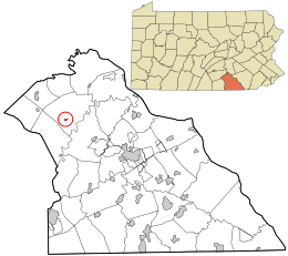
Mifflin Township is a township in Dauphin County, Pennsylvania, United States. The population was 816 at the 2020 census, an increase over the figure of 662 tabulated in 2000.

<span class="mw-page-title-main">Earl Township, Lancaster County, Pennsylvania</span> Township in Pennsylvania, United States

Earl Township is a township in northeastern Lancaster County, Pennsylvania, United States. The population was 7,149 at the 2020 census.

<span class="mw-page-title-main">Ephrata Township, Lancaster County, Pennsylvania</span> Township in Pennsylvania, United States

Ephrata Township is a township in northeastern Lancaster County, Pennsylvania, United States. The population was 10,391 at the 2020 census.

<span class="mw-page-title-main">Penn Township, Lancaster County, Pennsylvania</span> Township in Pennsylvania, United States

Penn Township is a township in north central Lancaster County, Pennsylvania, United States. The population was 10,224 at the 2020 census.

<span class="mw-page-title-main">Terre Hill, Pennsylvania</span> Borough in Pennsylvania, United States

Terre Hill is a borough in Lancaster County, Pennsylvania, United States. The population was 1,363 at the 2020 census.

<span class="mw-page-title-main">Warwick Township, Lancaster County, Pennsylvania</span> Township in Pennsylvania, United States

Warwick Township is a township in north-central Lancaster County, Pennsylvania, United States. The population was 19,068 at the 2020 census. It completely surrounds the borough of Lititz and contains the unincorporated villages of Brunnerville, Disston, Kissel Hill, Lexington, Millway, and Rothsville.

<span class="mw-page-title-main">Myerstown, Pennsylvania</span> Borough in the United States

Myerstown is a borough located in Lebanon County, Pennsylvania. It is part of the Lebanon, Pennsylvania Metropolitan statistical area. The population was 3,103 at the 2020 census. It is home to over 100 businesses, including a Bayer manufacturing plant, a GAF manufacturing plant, Farmer Boy Ag, Stoneridge Towne Centre and Wengers of Myerstown. The Evangelical Seminary is located on South College Street.

<span class="mw-page-title-main">North Cornwall Township, Pennsylvania</span> Township in Pennsylvania, United States

North Cornwall Township is a township in Lebanon County, Pennsylvania, United States. The population of North Cornwall Township was 8,511 as of the 2020 census. It is part of the Lebanon, PA Metropolitan Statistical Area.

<span class="mw-page-title-main">Watsontown, Pennsylvania</span> Borough in Pennsylvania, United States

Watsontown is a borough in Northumberland County, Pennsylvania, United States. The population was 2,351 at the 2010 census. It was named for John Watson, an early settler.

<span class="mw-page-title-main">Marysville, Pennsylvania</span> Borough in Pennsylvania, United States

Marysville is a borough in Perry County, Pennsylvania, United States. The population was 2,652 at the 2020 census. It is part of the Harrisburg–Carlisle Metropolitan Statistical Area.

<span class="mw-page-title-main">East Washington, Pennsylvania</span> Borough in Pennsylvania, United States

East Washington is a borough of Washington County, Pennsylvania, United States. The population was 1,858 at the 2020 census.

<span class="mw-page-title-main">Fawn Township, York County, Pennsylvania</span> Township in Pennsylvania, United States

Fawn Township is a township in York County, Pennsylvania, United States. The population was 3,011 at the 2020 census.

<span class="mw-page-title-main">Springfield Township, York County, Pennsylvania</span> Township in Pennsylvania, United States

Springfield Township is a township in York County, Pennsylvania, United States. The population was 6,023 at the 2020 census.

<span class="mw-page-title-main">Warrington Township, York County, Pennsylvania</span> Township in Pennsylvania, United States

Warrington Township is a township in York County, Pennsylvania, United States. The population was 4,547 at the 2020 census. The township is named after Warrington, England, like many townships having English names in York County. Others dispute the origin, believing it may be named after Waringstown, County Down, now in Northern Ireland.

References

  1. "2019 U.S. Gazetteer Files". United States Census Bureau. Retrieved July 28, 2020.
  2. 1 2 3 4 Bureau, US Census. "City and Town Population Totals: 2020-2021". Census.gov. US Census Bureau. Retrieved 9 July 2022.
  3. 1 2 "National Register Information System". National Register of Historic Places . National Park Service. March 13, 2009.
  4. 1 2 Barrett, Brenda. National Register of Historic Places Inventory/Nomination: Wellsville Historic District . National Park Service, 1976-10-18. Accessed 2009-12-24.
  5. "US Gazetteer files: 2010, 2000, and 1990". United States Census Bureau. 2011-02-12. Retrieved 2011-04-23.
  6. "Census of Population and Housing". U.S. Census Bureau. Retrieved 11 December 2013.
  7. 1 2 "U.S. Census website". United States Census Bureau . Retrieved 2008-01-31.
  8. "Incorporated Places and Minor Civil Divisions Datasets: Subcounty Resident Population Estimates: April 1, 2010 to July 1, 2012". Population Estimates. U.S. Census Bureau. Retrieved 11 December 2013.

Commons-logo.svg Media related to Wellsville, Pennsylvania at Wikimedia Commons