Shiloh, York County, Pennsylvania

Last updated

Shiloh
CDP
Shiloh PA God's Missionary Church.JPG
God's Missionary Church in Shiloh
York County Pennsylvania incorporated and unincorporated areas Shiloh highlighted.svg
Location in York County and the state of Pennsylvania.
Coordinates: 39°58′22″N76°47′44″W / 39.97278°N 76.79556°W / 39.97278; -76.79556
Country United States
State Pennsylvania
County York
Township West Manchester
Area
  Total4.2 sq mi (10.9 km2)
  Land4.2 sq mi (10.9 km2)
Population
 (2010)
  Total11,218
  Density2,700/sq mi (1,000/km2)
Time zone UTC-5 (Eastern (EST))
  Summer (DST) UTC-4 (EDT)

Shiloh is a census-designated place (CDP) in West Manchester Township, York County, Pennsylvania, United States. The population was 11,218 at the 2010 census.

Contents

Geography

According to the United States Census Bureau, the CDP has a total area of 4.2 square miles (10.9 km2), all land.

Demographics

As of the census of 2000, there were 10,192 people, 4,143 households, and 2,796 families living in the CDP. The population density was 2,422.6 inhabitants per square mile (935.4/km2). There were 4,262 housing units at an average density of 1,013.0 per square mile (391.1/km2). The racial makeup of the CDP was 95.39% White, 1.71% African American, 0.08% Native American, 1.48% Asian, 0.30% from other races, and 1.04% from two or more races. Hispanic or Latino of any race were 1.06% of the population.

There were 4,143 households, out of which 27.7% had children under the age of 18 living with them, 58.0% were married couples living together, 6.9% had a female householder with no husband present, and 32.5% were non-families. 27.3% of all households were made up of individuals, and 14.3% had someone living alone who was 65 years of age or older. The average household size was 2.34 and the average family size was 2.86.

In the CDP, the population was spread out, with 20.7% under the age of 18, 5.6% from 18 to 24, 26.8% from 25 to 44, 25.1% from 45 to 64, and 21.8% who were 65 years of age or older. The median age was 43 years. For every 100 females, there were 87.5 males. For every 100 females age 18 and over, there were 83.0 males.

The median income for a household in the CDP was $49,023, and the median income for a family was $55,918. Males had a median income of $41,444 versus $25,164 for females. The per capita income for the CDP was $23,625. About 2.7% of families and 4.6% of the population were below the poverty line, including 3.1% of those under the age of 18 and 6.8% ages 65 or older.

Related Research Articles

<span class="mw-page-title-main">Mesa Vista, California</span> Census-designated place in California, United States

Mesa Vista is a census-designated place (CDP) in Alpine County, California, United States. The population was 200 at the 2010 census, up from 182 at the 2000 census.

<span class="mw-page-title-main">Humboldt Hill, California</span> Census-designated place in Humboldt County, California, U.S.

Humboldt Hill is a census-designated place (CDP) in Humboldt County, California, United States. Humboldt Hill rises to an elevation of 636 feet (194 m). The population was 3,414 at the 2010 census, up from 3,246 at the 2000 census. The area is in the 95503 zip code and part of unincorporated Eureka.

<span class="mw-page-title-main">Valley Acres, California</span> Census-designated place in California, United States

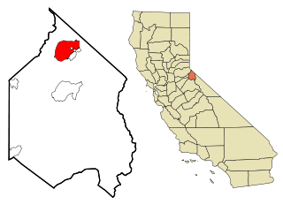
Valley Acres is a census-designated place (CDP) in Kern County, California, United States. Valley Acres is located 5.2 miles (8.4 km) north-northeast of Taft, at an elevation of 420 feet (128.02 m). The population was 527 at the 2010 census, up from 512 at the 2000 census.

<span class="mw-page-title-main">Dade City North, Florida</span> CDP in Florida, United States

Dade City North is a census-designated place (CDP) in eastern Pasco County, Florida, United States. The population was 3,319 at the 2000 census.

<span class="mw-page-title-main">Kalaheo, Hawaii</span> Census-designated place in Hawaii, United States

Kalāheo is an unincorporated community and census-designated place (CDP) in Kauaʻi County, island of Kauaʻi, Hawaiʻi, United States. The population was 4,996 at the 2020 census, up from 3,913 at the 2000 census.

<span class="mw-page-title-main">Orchard Homes, Montana</span> CDP in Montana, United States

Orchard Homes is a census-designated place (CDP) in Missoula County, Montana, United States. It is part of the Missoula Metropolitan Statistical Area. The population was 5,377 at the 2020 census.

<span class="mw-page-title-main">Heathcote, New Jersey</span> Populated place in Middlesex County, New Jersey, US

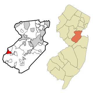
Heathcote is an unincorporated community and census-designated place (CDP) located within South Brunswick, in Middlesex County, in the U.S. state of New Jersey. As of the 2010 United States Census, the CDP's population was 5,821.

<span class="mw-page-title-main">Cedar Glen Lakes, New Jersey</span> Populated place in Ocean County, New Jersey, US

Cedar Glen Lakes is an unincorporated community and census-designated place (CDP) located within Manchester Township, in Ocean County, in the U.S. state of New Jersey. As of the 2010 United States Census, the CDP's population was 1,421.

<span class="mw-page-title-main">Garden City Park, New York</span> Hamlet and census-designated place in New York, United States

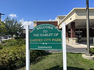
Garden City Park is a hamlet and census-designated place (CDP) located in the Town of North Hempstead in Nassau County, on Long Island, in New York, United States. The population was 7,806 at the 2010 census.

Shiloh is a census-designated place (CDP) in Harrison Township in Montgomery County, Ohio, United States. It was delineated as a census-designated place at the 2000 census, at which time its population was 11,272. It was not delineated as a CDP at the 2010 census. It is located directly north of the city of Dayton and is part of the Dayton Metropolitan Statistical Area.

<span class="mw-page-title-main">Woodbourne, Pennsylvania</span> Census-designated place in Pennsylvania, United States

Woodbourne is a census-designated place (CDP) in Bucks County, Pennsylvania, United States. The population was 3,851 at the 2010 census.

West Goshen was a census-designated place (CDP) in West Goshen Township, Chester County, Pennsylvania, United States. The population was 8,472 at the 2000 census. The CDP was not delineated for the 2010 census.

Jacksonville is a census-designated place (CDP) in Indiana County, Pennsylvania, United States. The population was 637 at the 2010 census. It was formerly an independent borough, until January 1, 1993 when it was returned to Black Lick Township, Pennsylvania.

<span class="mw-page-title-main">East Berwick, Pennsylvania</span> Census-designated place in Pennsylvania, United States

East Berwick is a census-designated place (CDP) in Salem Township, Luzerne County, Pennsylvania, United States. The population was 2,007 at the 2010 census.

<span class="mw-page-title-main">Friedensburg, Pennsylvania</span> CDP in Pennsylvania, United States

Friedensburg is a census-designated place (CDP) in Schuylkill County, Pennsylvania, United States. The population was 828 at the time of the 2000 census.

<span class="mw-page-title-main">Valley View, Schuylkill County, Pennsylvania</span> CDP in Pennsylvania, United States

Valley View is a census-designated place (CDP) in Schuylkill County, Pennsylvania, United States. The population was 1,677 at the 2000 census.

<span class="mw-page-title-main">Susquehanna Trails, Pennsylvania</span> CDP in Pennsylvania, United States

Susquehanna Trails is a census-designated place (CDP) in York County, Pennsylvania, United States. The population was 2,264 at the 2010 census.

Shiloh is a census-designated place (CDP) in Sumter County, South Carolina, United States. The population was 259 at the 2000 census. It is included in the Sumter, South Carolina Metropolitan Statistical Area.

<span class="mw-page-title-main">Tonawanda (CDP), New York</span> Census-designated place in New York, United States

Tonawanda is a census-designated place (CDP) in Erie County, New York, United States. The CDP comprises the town of Tonawanda minus its subsidiary village of Kenmore. As of the 2010 census, the CDP population was 58,144.

<span class="mw-page-title-main">Clearbrook, New Jersey</span> Populated place in Middlesex County, New Jersey, US

Clearbrook is a gated community and census-designated place (CDP) located in Monroe Township, Middlesex County, in the U.S. state of New Jersey. It is in the western part of the township, bordered to the north by Encore at Monroe and to the east by Concordia and The Ponds. It is 3.5 miles (5.6 km) southwest of Jamesburg and 5 miles (8 km) northeast of Hightstown.

References