Crickley Hill and Barrow Wake

Last updated

Crickley Hill and Barrow Wake
Site of Special Scientific Interest
View from Barrow Wake towards Crickley Hill - geograph.org.uk - 986696.jpg
Looking from Barrow Wake to Crickley Hill
Gloucestershire UK location map.svg
Red pog.svg
Location within Gloucestershire
Location Gloucestershire
Grid reference SO929161 & SO931154
Coordinates 51°50′38″N2°06′13″W / 51.843905°N 2.10374°W / 51.843905; -2.10374
InterestBiological/Geological
Area56.8 hectare
Notification 1974
Natural England website

Crickley Hill and Barrow Wake (grid reference SO929161 & grid reference SO931154 ) is a 56.8-hectare (140-acre) biological and geological Site of Special Scientific Interest in Gloucestershire, notified in 1974. [1] [2]

Contents

The site (two parts) lies within the Cotswold Area of Outstanding Natural Beauty. It was formerly known as Crickley Hill and includes some of a site known as Tuffleys Quarry. Part of the site is owned and managed by Gloucestershire Willdlife Trust and the National Trust as a nature reserve Park. [1] [3] The Cotswold Way National Trail passes through Crickley Hill and Barrow Wake. [4]

Barrow Wake and Tuffley's Quarry are listed in the 'Cotswold District' Local Plan 2001–2011 (on line) as Key Wildlife Sites. [5] Crickley Hill is listed in the 'Cotswold District' Local Plan 2001–2011 (on line) as an SSSI and Regionally Important Geological Site. [6] [7]

Location

The site lies south of Cheltenham on the Cotswold scarp and it supports a range of habitats characteristic of the Cotswold limestone. It includes species-rich grassland, semi-natural woodland, scrub and particularly nationally important rock exposures. [1] [3]

Biological interest

The site supports several types of grassland and the turf contains many lime-loving herbs. There are several species of orchid recorded such as early purple orchid, bee orchid, and musk orchid. Viper's bugloss flowers in abundance. This diversity supports a varied invertebrate fauna (butterflies, moths and local snails). [1] [3]

The site includes the Scrubbs and Crickley Woods which are areas of mature Beech woodland with regenerating Beech and Ash. [1] [3] Short Wood is an area of Oak parkland. [3]

The scarp slopes provide basking areas for adders. [3]

Geological interest

The rock exposures constitute a key Jurassic locality and show a major section in the Lower Inferior Oolite. There are extensive exposures of Lower and Middle Jurassic rocks and these exhibit the best sections in the Cotswolds in the Pea Grit and the overlying Coral Bed. [1] [3]

Crickley Hill is part of the Cotswold escarpment which runs from Dorset to the Yorkshire Coast. The stone has been quarried for hundreds of years and was probably used for dry stone walling.

Archaeology

There is evidence of settlements over 5,000 years back. As the soil is thin on the hill the evidence lies close to the surface under the grassland. The site has been excavated each summer period from 1969 to 1993 and is considered to be of international importance as a result of the findings. These point to occupation by humans over 4,000 years (Neolithic period) to a post-Roman period. [3]

The archaeologists have stayed regularly at Ullenwood Camp close to Crickley Hill for the excavation period.

Crickley Hill Country Park

The Crickley Hill Country Park was established in 1979 with assistance from the then Countryside Commission. Access to the countryside at this park provides limestone grassland; beech woodlands, oak parkland; an archaeological site and panoramic views. [3]

There is a range of self-guided trails with supporting leaflets. These include Hill Fort Trail; Scrubbs Trail; Scarp Trail; Family Trail and Park Trail. There are also circular walks of different lengths (5 and 8.5 miles). [3]

Crickley Hill is wardened by Gloucestershire Wildlife Trust, The National Trust and volunteers from the Cotswold Warden Service. [3]

Literary associations

Crickley Hill was immortalised by Ivor Gurney in his poem of that name (from 1919), recounting how mention and memory of the ridge led to bonding on the Western Front, [8] the hill epitomising in local miniature the England for which they felt they were fighting. [9]

Related Research Articles

The Gloucestershire Wildlife Trust is the Gloucestershire local partner in a conservation network of 46 Wildlife Trusts. The Wildlife Trusts are local charities with the specific aim of protecting the United Kingdom's natural heritage. The Gloucestershire Wildlife Trust is managed by a board of trustees elected from its membership who provide overall direction for the development of the trust and there are advisory committees. The work of the trust is carried out through staff and volunteers.

<span class="mw-page-title-main">Uley Bury</span>

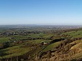
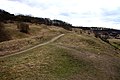
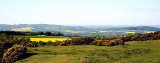
Uley Bury is the long, flat-topped hill just outside Uley, Gloucestershire, England. It is an impressive multi-vallate, scarp-edge Iron Age hill fort dating from around 300 B.C. Standing some 750 feet above sea level it has views over the Severn Vale.

<span class="mw-page-title-main">Strawberry Banks</span> Biological Site of Special Scientific Interest in Gloucestershire, England

Strawberry Banks is a 5.06-hectare (12.5-acre) biological Site of Special Scientific Interest in Gloucestershire, notified in 1993.

<span class="mw-page-title-main">Selsley</span> Human settlement in England

Selsley is a village within the civil parish of King's Stanley and district of Stroud, in Gloucestershire, England. It is composed of around 175 houses, scattered around the western and eastern edge of a Cotswold spur, located approximately 2 miles (3.2 km) south of Stroud.

<span class="mw-page-title-main">Daneway Banks SSSI</span> Biological Site of Special Scientific Interest in Gloucestershire, England

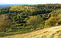
Daneway Banks is a 17-hectare (42-acre) biological Site of Special Scientific Interest in Gloucestershire, notified in 1954 and renotified in 1983. It lies half a mile west of Sapperton and is part of a group of wildlife sites in the Frome Valley that includes Siccaridge Wood and Sapperton Canal reserves. The site is in the Cotswold Area of Outstanding Natural Beauty.

<span class="mw-page-title-main">Wotton Hill</span> Hill in Gloucestershire, England

Wotton Hill is a hill on the edge of the Cotswold Hills in Gloucestershire, England, 0.5 miles (0.80 km) north of Wotton-under-Edge. The Cotswold Way passes over the hill.

Lower Wye Gorge is a 65-hectare (160-acre) biological and geological Site of Special Scientific Interest in Gloucestershire, notified in 1954 and renotified 1987. The site includes two Gloucestershire Wildlife Trust nature reserves being Ban-y-gor Wood and Lancaut. The Natural England citation states a revision for Lancaut inclusion.

<span class="mw-page-title-main">Swift's Hill SSSI</span> Geological site in England

Swift's Hill is a 9.15-hectare (22.6-acre) biological and geological Site of Special Scientific Interest in Gloucestershire, notified in 1966 and renotified in 1984.

<span class="mw-page-title-main">Bull Cross, The Frith and Juniper Hill</span> Site of Special Scientific Interest in Gloucestershire, England

Bull Cross, The Frith and Juniper Hill is a 42.33-hectare (104.6-acre) biological and geological Site of Special Scientific Interest in Gloucestershire, notified in 1954. The site is listed in the ‘Stroud District’ Local Plan, adopted November 2005, Appendix 6 as an SSSI and Regionally Important Geological Site (RIGS).

<span class="mw-page-title-main">Cleeve Common</span>

Cleeve Common is a 455-hectare (1,120-acre) biological and geological Site of Special Scientific Interest in Gloucestershire, England, notified in 1974. It is looked after by a small charity called Cleeve Common Trust, formally Cleeve Common Board of Conservators.

<span class="mw-page-title-main">Cockleford Marsh</span> Biological Site of Special Scientific Interest in Gloucestershire, England

Cockleford Marsh is a 3.2-hectare (7.9-acre) biological Site of Special Scientific Interest in Gloucestershire, notified in 1991.

<span class="mw-page-title-main">Cotswold Commons and Beechwoods</span> Biological Site of Special Scientific Interest in Gloucestershire, England

Cotswold Commons and Beechwoods is a 665.5-hectare (1,644-acre) biological Site of Special Scientific Interest in Gloucestershire, notified in 1954.

<span class="mw-page-title-main">Edge Common</span>

Edge Common is a 20.47-hectare (50.6-acre) biological Site of Special Scientific Interest in Gloucestershire, notified in 1974.

<span class="mw-page-title-main">Leckhampton Hill and Charlton Kings Common</span>

Leckhampton Hill and Charlton Kings Common is a 63.8-hectare (158-acre) biological and geological Site of Special Scientific Interest in Gloucestershire, notified in 1954. There are five units of assessment.

<span class="mw-page-title-main">Lineover Wood</span>

Lineover Wood is a 20.3-hectare (50-acre) biological Site of Special Scientific Interest in Gloucestershire, notified in 1986.

<span class="mw-page-title-main">Minchinhampton Common</span> Site of Special Scientific Interest in Gloucestershire

Minchinhampton Common is a 182.7-hectare (451-acre) biological and geological Site of Special Scientific Interest in Gloucestershire, notified in 1972.

<span class="mw-page-title-main">Puckham Woods</span> Biological Site of Special Scientific Interest in Gloucestershire, England

Puckham Woods is a 32.38-hectare (80.0-acre) biological Site of Special Scientific Interest in Gloucestershire to the east of Cheltenham near Whittington, notified in 1954. The site is listed in the 'Cotswold District' Local Plan 2001-2011 as a Key Wildlife Site (KWS).

<span class="mw-page-title-main">Rodborough Common, Gloucestershire</span> Biological and geological Site of Special Scientific Interest in Gloucestershire, United Kingdom

Rodborough Common is a 116.0-hectare (287-acre) biological and geological Site of Special Scientific Interest in Gloucestershire, notified in 1954. The site is listed in the ‘Stroud District’ Local Plan, adopted November 2005, Appendix 6 as an SSSI and a Regionally Important Geological Site (RIGS). The Common is also a Special Area of Conservation (SAC) under the EU Habitats Directive

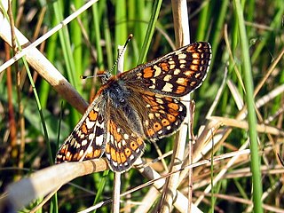
Rough Bank, Miserden is a 9.2-hectare (23-acre) biological Site of Special Scientific Interest in Gloucestershire, notified in 1986. It was purchased by the wildlife charity Butterfly Conservation in 2012.

References

  1. 1 2 3 4 5 6 Natural England SSSI information on the citation
  2. "Tewkesbury Borough Local Plan to 2011, adopted March 2006, Appendix 3 'Nature Conservation', Sites of Special Scientific Interest". Archived from the original on 3 March 2016. Retrieved 10 October 2012.
  3. 1 2 3 4 5 6 7 8 9 10 11 https://www.gloucestershirewildlifetrust.co.uk/nature-reserves/crickley-hill
  4. Cotswold Way National Trail and see picture gallery below.
  5. Cotswold District Local Plan, Appendix 2, Key Wildlife Sites Archived October 13, 2013, at the Wayback Machine
  6. Cotswold District Local Plan, Appendix 1, Sites of Special Scientific Interest Archived March 26, 2012, at the Wayback Machine
  7. Cotswold District Local Plan, Appendix 3, Regionally Important Geological Sites Archived March 26, 2012, at the Wayback Machine
  8. J. Stallworthy/J. Potter eds., Three Poets of the First World War (Penguin 2011) p. 12 and p. 120-1
  9. R. Gill, Mastering English Literature (2006) p. 500

Archaeological publications

SSSI Source