Critzer, Kansas | |
|---|---|
 Critzer  Critzer | |
| Coordinates: 38°08′24″N94°54′46″W / 38.14000°N 94.91278°W [1] | |
| Country | United States |
| State | Kansas |
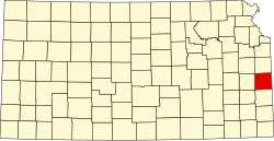
| County | Linn |
| Elevation | 886 ft (270 m) |
| Time zone | UTC-6 (CST) |
| • Summer (DST) | UTC-5 (CDT) |
| Area code | 913 |
| FIPS code | 20-16410 |
| GNIS ID | 484831 [1] |
Critzer is an unincorporated community in Linn County, Kansas, United States. [1]