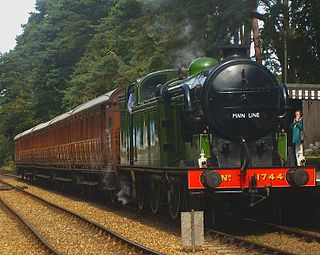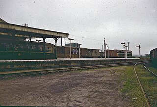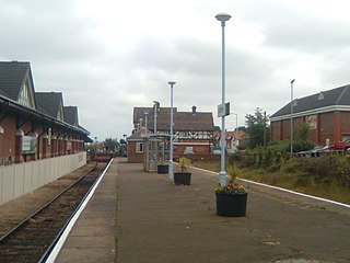
The North Norfolk Railway (NNR) – also known as the "Poppy Line" – is a 5+1⁄4-mile (8.4 km) heritage steam railway in Norfolk, England, running between the towns of Sheringham and Holt. The North Norfolk Railway is owned and operated as a public limited company, originally called Central Norfolk Enterprises Limited. The railway is listed as exempt from the UK Railways (Interoperability) Regulations 2000.

The Bure Valley Railway is a 15 in minimum gauge visitors' attraction in Norfolk, England. It was created on the original disused full-gauge bed of a defunct passenger service to incorporate a new, adjacent pedestrian footpath.

Cromer is a coastal town and civil parish on the north coast of the English county of Norfolk. It is 23 miles north of Norwich, 116 miles north-northeast of London and four miles east of Sheringham on the North Sea coastline. The local government authorities are North Norfolk District Council, whose headquarters is on Holt Road in the town, and Norfolk County Council, based in Norwich. The civil parish has an area of 4.66 km2 and at the 2011 census had a population of 7,683.

The Cromer Tunnel was built by the Norfolk and Suffolk Joint Railway to take their Cromer Beach to Mundesley line under the Great Eastern's Cromer High to Norwich line. Both portals of the tunnels are open but undergrowth and modern housing in the area make access difficult.

The Bittern Line is a railway branch line in Norfolk, England, that links Norwich to Sheringham. It passes through the Broads on its route to an Area of Outstanding Natural Beauty on the north Norfolk coast. It is named after the bittern, a rare bird found in the reedy wetlands of Norfolk.

Norwich railway station is the northern terminus of the Great Eastern Main Line in the East of England, serving the city of Norwich, Norfolk. It is 114 miles 77 chains (185.0 km) down the main line from London Liverpool Street, the western terminus.

King's Lynn railway station is the northern terminus of the Fen line in the east of England, serving the town of King's Lynn, Norfolk. It is 41 miles 47 chains (66.9 km) from Cambridge and 96 miles 75 chains (156.0 km) measured from London Liverpool Street.

North Walsham railway station is on the Bittern Line in Norfolk, England, serving the town of North Walsham. It is 16 miles (26 km) down the line from Norwich, between Worstead to the south and Gunton to the north.
The Wrexham and Minera Railway or Wrexham and Minera Branch was a railway line in North Wales between the town of Wrexham, the village of Brymbo where it served the Brymbo Steelworks, and the lead mines and limeworks at Minera. A further branch ran from Brymbo to Coed Talon, where it connected with lines to Mold. The system was constructed in several stages between 1844 and 1872, while the various lines making up the system closed in 1952, 1972 and 1982.
The Norfolk and Suffolk Joint Railway (NSJR) was a British joint railway company.

Roughton Road railway station is on the Bittern Line in Norfolk, England, on the outskirts of the town of Cromer. It takes its name from the street on which it is located, and is several miles north of the village of Roughton. It is 24 miles 1 chain (38.6 km) down the line from Norwich and is situated between Gunton and Cromer stations.

The fishing port and holiday resort of Cromer in the English county of Norfolk has had a rail service since 1877. It was served by three railway stations for many years, and is now served by two. Cromer Beach station, which opened in 1887, was renamed Cromer following the closure of the other early stations.

Sheringham railway station is the northern terminus of the Bittern Line in Norfolk, England, serving the town of Sheringham. It is 30 miles 22 chains down the line from Norwich. Its three-letter station code is SHM.

Birkenhead Town railway station is a disused railway station in Birkenhead, Wirral, England. It was located near the current entrance to the Queensway Tunnel on Grange Road.
Cromer Links Halt was a railway station on the outskirts of Cromer. It was on the now disused Norfolk and Suffolk Joint Railway line between Roughton Road Junction and Overstrand station. It opened on 9 July 1923, only to close thirty years later on 7 April 1953.

Wells-next-the-Sea railway station served the port town of Wells-next-the-Sea in North Norfolk, England. It was opened in 1857 by the Wells & Fakenham Railway, later part of the Great Eastern Railway's Wymondham to Wells branch, and became a junction in 1866 with the arrival of the West Norfolk Junction Railway. It closed in 1964.

Cromer is a railway station in the English county of Norfolk. Because the Midland and Great Northern Joint Railway (M&GNJR) line approached Cromer from the west, following the coastal clifftops, it avoided the steep escarpment which had prevented the earlier line from Norwich running all the way into the town. Consequently, it became possible to build a far more conveniently located station, near to the town centre and the beach. The station opened as Cromer Beach on 16 June 1887 and was renamed Cromer on 20 October 1969, following the closure of Cromer High station in 1954. It is 26 miles 52 chains (42.9 km) down the line from Norwich. Cromer is one of only two former Midland and Great Northern Joint Railway stations to remain operational on the National Rail network; the other being the neighbouring West Runton. Sheringham and Weybourne are the other two surviving M&GNJR stations, both still served today on the heritage North Norfolk Railway.

Holt railway station served the town of Holt in Norfolk, England. It was part of the Midland and Great Northern Joint Railway network, which spread over much of East Anglia, providing connections to Cromer, Norwich and Yarmouth. Closed in 1964, there are proposals afoot to rebuild the line through the locality as part of an orbital railway scheme.

The East Norfolk Railway was a pre-grouping railway company operating a standard gauge 25 mile, mostly single track, railway running between Norwich Thorpe railway station and Cromer in the English county of Norfolk. It opened in 1874, reaching Cromer three years later, and remains mostly operational. The company also operated a branch between Wroxham and County School, which closed to passengers in 1952, and had proposed a branch to Blakeney in 1878, which was never constructed.
The Wymondham to Wells Branch was a railway built in stages by the Norfolk Railway, Eastern Counties Railway and Wells and Fakenham Company between 1847 and 1857. The railway ran from Wymondham in the south, through Dereham and Fakenham to the coastal town of Wells-next-the-Sea; more specifically, the line ran from Wymondham South Junction, where it met the present-day Breckland Line. Passenger services along the line lasted until 1969; the railway continued to be used for freight until 1989. The southern section of the railway now forms the Mid-Norfolk Railway, with part of the northern section serving as the narrow gauge Wells and Walsingham Light Railway.


