Cromford Wharf

Last updated

A former transit shed at Cromford Wharf. Cromford Wharf 2008.jpg
A former transit shed at Cromford Wharf.
This building on the wharf is now a cafe. Cromford Canal Wharf (cafe).jpg
This building on the wharf is now a cafe.
Rear of the buildings at Cromford Wharf. Cromford Wharf - Canal end 29-04-06.jpg
Rear of the buildings at Cromford Wharf.

Cromford Wharf is at Cromford in Derbyshire, England.

Contents

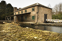
It is located at the northern terminus of the Cromford Canal, which opened in 1794 and ran 14.5 miles (23 km) from here to the Erewash Canal in Derbyshire. The wharf stands on Mill Lane opposite Richard Arkwright's Cromford Mill, and surviving buildings include two warehouses - one of which is now a cafe - an office or counting house, and two cottages. The wharf was once totally enclosed by a stone perimeter wall, which included other buildings, but these buildings have not survived.

The yard serves today as a car park.

The Canal Warehouse was built in 1794, soon after the canal opened, and is known as the Gothic Warehouse, after the design of the side elevation. (These Gothic castellations, just visible in the top picture, were probably included at the insistence of Sir Richard Arkwright, who would be able to see it from Willersley Castle, his intended home. [1] ) This warehouse was owned by Nathaniel Wheatcroft, a principal carrier on the canal. Today the Arkwright Society manages the Warehouse, having leased it since 1995, where two rooms are used as classrooms, and public exhibitions are sometimes held there. The Society offers tours of the Wharf and the canal.

A second warehouse was constructed in 1824, and was used to store goods awaiting carriage by boat, protected by the overhanging awning. Today a café and wildlife shop are open on the ground floor of this building.

Construction of the Counting House started in 1794.

The Wharf Cottages were built in 1796 for administrative staff.

The canal towpath, which starts at the Wharf, can be followed to High Peak Junction (the start of the High Peak Trail), and as far as Whatstandwell and Ambergate. This 6-mile (10 km) section is listed as a Biological Site of Special Scientific Interest (SSSI), [2] and also forms part of the Derwent Valley Heritage Way.

Cromford Canal
BSicon uWHRF.svg
Cromford Wharf
BSicon uddSTRl.svg
High Peak Junction
BSicon ueTEEnl.svg
BSicon PUMPHOUSE.svg
Leawood Pumping Station
BSicon uhKRZWae.svg
BSicon WASSERq.svg
BSicon uexnKSTRe.svg
Leawood Aqueduct River Derwent
BSicon uENDExe.svg
End of navigable section
BSicon uexSTR.svg
BSicon gFABZgl+l.svg
BSicon gSTRq.svg
Nightingale Arm
BSicon CONTgq.svg
BSicon uxmKRZo.svg
BSicon CONTfq.svg
Aqueduct
BSicon uexKRZo.svg
High Peak Aqueduct
BSicon uexTUNNEL1.svg
76
yards
Gregory Tunnel
BSicon ugENDExa.svg
BSicon ugSTRfr.svg
Ambergate
BSicon gTUNNEL1.svg
Hag Tunnel
BSicon gWBRUCKE2.svg
River Amber Aqueduct
BSicon gSKRZ-Au.svg
A610 Ripley - Ambergate Road
BSicon gTUNNEL1.svg
33
yards
Buckland Hollow Tunnel
BSicon CONTgq.svg
BSicon gmKRZu.svg
BSicon CONTfq.svg
Midland Main Line
BSicon gtSTRa.svg
3063
yards
Butterley Tunnel
BSicon gTEEtgnl.svg
BSicon uRESRr.svg
Butterley Reservoir and feeder
BSicon gtSTR.svg
BSicon uexWHRF.svg
Pinxton Wharf
BSicon gtSTRe.svg
BSicon ugENDExa.svg
BSicon guENDExe.svg
BSicon CONTgq.svg
BSicon gmKRZu.svg
BSicon CONTfq.svg
Erewash Valley line
BSicon uexTEEnl.svg
BSicon uRESRr.svg
BSicon gSTR.svg
Codnor Park Reservoir and feeder
BSicon ugENDExa.svg
BSicon CONTgq.svg
BSicon gmKRZu.svg
BSicon CONTfq.svg
Midland Railway – Butterley
BSicon gFABZgl+l.svg
BSicon gSTRq.svg
BSicon gSTRr.svg
BSicon ugLOCKSu.svg
1-7
Codnor Park Locks (7)
BSicon gFABZgl+l.svg
BSicon ugddHSTRf.svg
Portland Basin
BSicon CONTgq.svg
BSicon gmKRZu.svg
BSicon CONTfq.svg
Erewash Valley line
BSicon ugLock5.svg
8
Butterley Co Lock
BSicon ugLock5.svg
9
Stoneyford Lock
BSicon ugLock5.svg
10
Stoneyford Deep Lock
BSicon ugLock5.svg
11
Stoneyford Shallow Lock
BSicon geuKRZo.svg
Erewash Aqueduct
BSicon ugLock5.svg
12
Vickers Lock
BSicon ugLock5.svg
13
Strutts Lock
BSicon gSKRZ-Au.svg
A610 road bridge
BSicon guENDE.svg
BSicon ueTEEnl.svg
BSicon uRESRr.svg
Moorgreen Reservoir and feeder
BSicon uFABZgl+l.svg
BSicon uddHSTRg.svg
BSicon lENDE@F.svg
BSicon uSTR+r.svg
Langley Mill Basin
BSicon uSTR.svg
BSicon gSTRl.svg
Nottingham Canal
BSicon uLock5.svg
14
Langley Bridge Lock
BSicon uSKRZ-Au.svg
A608 Derby Road bridge
BSicon uENDE.svg
Erewash Canal

See also

Related Research Articles

Derwent Valley Mills World Heritage site in Derbyshire, England

Derwent Valley Mills is a World Heritage Site along the River Derwent in Derbyshire, England, designated in December 2001. It is administered by the Derwent Valley Mills Partnership. The modern factory, or 'mill', system was born here in the 18th century to accommodate the new technology for spinning cotton developed by Richard Arkwright. With advancements in technology, it became possible to produce cotton continuously. The system was adopted throughout the valley, and later spread so that by 1788 there were over 200 Arkwright-type mills in Britain. Arkwright's inventions and system of organising labour was exported to Europe and the United States.

River Derwent, Derbyshire River in Derbyshire, England

The Derwent is a river in Derbyshire, England. It is 50 miles (80 km) long and is a tributary of the River Trent, which it joins south of Derby. Throughout its course, the river mostly flows through the Peak District and its foothills.

Richard Arkwright English inventor and entrepreneur (1732–1792)

Sir Richard Arkwright was an English inventor and a leading entrepreneur during the early Industrial Revolution. He is credited as the driving force behind the development of the spinning frame, known as the water frame after it was adapted to use water power; and he patented a rotary carding engine to convert raw cotton to 'cotton lap' prior to spinning. He was the first to develop factories housing both mechanised carding and spinning operations.

Whatstandwell Human settlement in England

Whatstandwell is a village on the River Derwent in the Amber Valley district of Derbyshire, England. It is about five miles south of Matlock and about four miles north of Belper. Whatstandwell railway station is located on the Derby-Matlock Derwent Valley Line, and the A6 trunk road crosses the River Derwent in the village. Most of the population is included in the civil parish of Crich but the village may be said to extend across the Derwent into the parish of Alderwasley.

Cromford Human settlement in England

Cromford is a village and civil parish in Derbyshire, England, in the valley of the River Derwent between Wirksworth and Matlock. It is first mentioned in the 11th-century Domesday Book as Crumforde, a berewick of Wirksworth and this remained the case throughout the Middle Ages. The population at the 2011 Census was 1,433. It is principally known for its historical connection with Richard Arkwright, and the nearby Cromford Mill which he built outside the village in 1771. Cromford is in the Derwent Valley Mills World Heritage Site.

Water frame Water-powered spinning frame

The water frame is a spinning frame that is powered by a water-wheel. Water frames in general have existed since Ancient Egypt times. Richard Arkwright, who patented the technology in 1769, designed a model for the production of cotton thread; this was first used in 1765. The Arkwright water frame was able to spin 96 threads at a time, which was an easier and faster method than ever before. The design was partly based on a spinning machine built for Thomas Highs by clockmaker John Kay, who was hired by Arkwright. Being run on water power, it produced stronger and harder yarn than the then-famous "spinning jenny", and propelled the adoption of the modern factory system.

Cromford Canal

The Cromford Canal ran 14.5 miles from Cromford to the Erewash Canal in Derbyshire, England with a branch to Pinxton. Built by William Jessop with the assistance of Benjamin Outram, its alignment included four tunnels and 14 locks.

Cromford railway station Railway station in Derbyshire, England

Cromford railway station is a Grade II listed railway station owned by Network Rail and managed by East Midlands Railway. It is located in the village of Cromford in Derbyshire, England. The station is on the Derwent Valley Line 15+12 miles (24.9 km) north of Derby towards Matlock.

Ambergate Human settlement in England

Ambergate is a village in Derbyshire, England, situated where the River Amber joins the River Derwent, and where the A610 road from Ripley and Nottingham joins the A6 that runs along the Derwent valley between Derby to the south and Matlock to the north. Sawmills and Ridgeway are neighbouring hamlets, and Alderwasley, Heage, Nether Heage and Crich are other significant neighbouring settlements. The village forms part of the Heage and Ambergate ward of Ripley Town Council with a population of 5,013 at the 2011 Census. Ambergate is within the Derwent Valley Mills UNESCO World Heritage site, and has historical connections with George Stephenson; Ambergate is notable for its railway heritage and telephone exchange. Ambergate has an active community life, particularly centred on the school, pubs, churches, sports clubs; and annual village carnival which is relatively large and consistent locally, with popular associated events in carnival week and throughout the year. The carnival is organised by a voluntary committee. Shining Cliff woods, Thacker's woods and Crich Chase border the village.

Lumford Mill

Lumford Mill was a historic cotton mill at Bakewell in Derbyshire, England.

Bullbridge Human settlement in England

Bullbridge is a small village in Derbyshire. The Bull bridge accident, in which a railway bridge failed as a goods train was just passing over it, happened here in 1860.

Bentley Brook

Bentley Brook is a stream in Derbyshire, England. It rises on Matlock Moor, flowing south through Cuckoostone Dale, under the A632, into Lumsdale, gathering the valley's waters—notably from Knabhall Brook, out of Tansley, itself dammed and supporting large mills. In Lumsdale it enters a now disused mill pond or reservoir, then flows over a waterfall in the course of passing several historical mill ruins. Finally, it runs through control gates into the outside bend of a tight oxbow of the River Derwent, just beyond Hall Leys Park in Matlock. Although only about five miles in length, Bentley Brook is classed as a 'main river' by the Environment Agency.

The Arkwright Society is a registered charity engaged in the conservation of industrial monuments in Derbyshire, focusing on the water mills of Lumsdale Valley, Ashford, Cromford and Slinter Wood. It is named after Richard Arkwright who founded the world's first successful water powered cotton spinning mill in Cromford in 1771. The society was founded after a festival in 1971 to commemorate the 200th anniversary of this feat.

Cromford Mill

Cromford Mill is the world's first water-powered cotton spinning mill, developed by Richard Arkwright in 1771 in Cromford, Derbyshire, England. The mill structure is classified as a Grade I listed building. It is now the centrepiece of the Derwent Valley Mills UNESCO World Heritage Site, and is a multi-use visitor centre with shops, galleries, restaurants and cafes.

Derwent Valley Heritage Way Long distance footpath in England

The Derwent Valley Heritage Way (DVHW) is a 55 miles (89 km) waymarked footpath along the Derwent Valley through the Peak District. The walk starts from Ladybower Reservoir in the Peak District National Park via Chatsworth, the scenery around the Derbyshire Dales, and through the Derwent Valley Mills World Heritage Site. It follows the Riverside Path through Derby and continues onwards to the historic inland port of Shardlow. Journey's end is at Derwent Mouth where the River Derwent flows into the River Trent.

Willersley Castle House in Derbyshire, United Kingdom

Willersley Castle is a late 18th-century country mansion above the River Derwent at Cromford, Derbyshire, outside Peak District National Park. The castle has been a Grade II* listed building since April 2000.

Masson Mill Cotton mill in Derbyshire, England

Sir Richard Arkwright's Masson Mill is a water-powered cotton spinning mill situated on the west bank of the River Derwent in Matlock Bath, Derbyshire in England. This mill was built in 1783. It forms part of the Derwent Valley Mills, a World Heritage Site. Nearby is Willersley Castle, the house Richard Arkwright built for himself within the parish of Matlock.

High Peak Junction

High Peak Junction, near Cromford, Derbyshire, England, is the name now used to describe the site where the former Cromford and High Peak Railway (C&HPR), whose workshops were located here, meets the Cromford Canal. It lies within Derwent Valley Mills World Heritage Site, designated in 2001, and today marks the southern end of the High Peak Trail, a 17 miles (27 km) trail for walkers, cyclists and horse riders. The Derwent Valley Heritage Way also passes this point, and popular walks lead from here along the towpath in both directions.

Lumsdale Valley Valley in the Derbyshire Peak District

Lumsdale Valley is a steep-sided wooded gorge in the Peak District near Matlock, Derbyshire, in England. It is the location of a series of historic water-powered mills.

Cromford is a civil parish in the Derbyshire Dales district of Derbyshire, England. The parish contains 89 listed buildings that are recorded in the National Heritage List for England. Of these, two are listed at Grade I, the highest of the three grades, seven are at Grade II*, the middle grade, and the others are at Grade II, the lowest grade. The parish contains the village of Cromford and the surrounding area. The parish is important because it was here that Richard Arkwright built the first water-powered mill, and created the "first industrial community of its type in the world". The first workers' houses were built in North Street, and each has three storeys, the top floor being a workshop. There are listed at Grade II*. Many houses were built later for the workers by Arkwright and his successors, and these had two or three storeys, but no workshop, and each had a standard pattern of two bays, with the doorway in one bay, windows in the other bay, and services at the rear. These are listed at Grade II. Arkwright's original factory and the subsequent associated buildings are listed at Grade I.

References

  1. Potter (2003). Cromford Canal. The History Press.
  2. "Cromford Canal: Site of Special Scientific Interest, Natural England".

Coordinates: 53°06′32″N01°33′21″W / 53.10889°N 1.55583°W / 53.10889; -1.55583