Related Research Articles

The Erie Canal is a historic canal in upstate New York that runs east–west between the Hudson River and Lake Erie. Completed in 1825, the canal was the first navigable waterway connecting the Atlantic Ocean to the Great Lakes, vastly reducing the costs of transporting people and goods across the Appalachians. The Erie Canal accelerated the settlement of the Great Lakes region, the westward expansion of the United States, and the economic ascendancy of New York state. It has been called "The Nation's First Superhighway."
Seneca Lake is the largest of the glacial Finger Lakes of the U.S. state of New York, and the deepest glacial lake entirely within the state. It is promoted as the lake trout capital of the world, and is host of the National Lake Trout Derby. Because of its depth and relative ease of access, the US Navy uses Seneca Lake to perform test and evaluation of equipment ranging from single element transducers to complex sonar arrays and systems. The lake takes its name from the Seneca nation of Native Americans. At the north end of Seneca Lake is the city of Geneva, New York, home of Hobart and William Smith Colleges and the New York State Agricultural Experiment Station, a division of Cornell University. At the south end of the lake is the village of Watkins Glen, New York, famed for auto racing and waterfalls.

Hammondsport is a village in Steuben County, New York, United States. First settled in 1792 the village is located at the south end of Keuka Lake, one of the Finger Lakes. Beginning in the 1790s the village began to take form, which included a courthouse and a jail. In the 1850s vineyards and the wine industry began to emerge in and around Hammondsport. Pioneer aviation engineer and pilot Glenn Curtiss was born in Hammondsport, where he built several types of aircraft, and the first seaplanes, which were tested in Keuka Lake. Hammondsport features a village square, historic buildings, wineries, breweries and museums. Nearby municipalities contain vineyards, and wineries and grape-packing have played a major role in the economy. In 1935, heavy rains lasting three days resulted in mudslides and major flooding, ruining or damaging many homes and structures in Hammondsport, situated at the hillside. A number of buildings surrounding Pulteney Square make up the Pulteney Square Historic District and are listed in the National Register of Historic Places

Dresden is a village in Yates County, New York, United States. The population was 308 at the 2010 census. The village was named after Dresden in Germany.

Milo is a town in Yates County, New York, United States. The population was 7,006 at the 2010 census. The town was named after Milo of Croton, a famous athlete from Ancient Greece.

Torrey is a town in Yates County, New York, United States. The population was 1,282 at the 2010 census. The name is taken from that of early county political leader Henry Torrey.

The Delaware and Raritan Canal is a canal in central New Jersey, built in the 1830s, that connects the Delaware River to the Raritan River. It was an efficient and reliable means of transportation of freight between Philadelphia and New York City, transporting anthracite coal from eastern Pennsylvania during much of the 19th and early 20th centuries. The canal allowed shippers to cut many miles off the existing route from the Pennsylvania Coal Region down the Delaware, around Cape May, and up the occasionally treacherous Atlantic Ocean coast to New York City.

Keuka Lake is one of the major Finger Lakes in the U.S. state of New York. It is unusual because it is Y-shaped, in contrast to the long and narrow shape of the other Finger Lakes. Because of its shape, it was referred to in the past as Crooked Lake. Keuka means "canoe landing" or "lake with an elbow" in the Seneca language. The first white settlers to the lake region came after the Sullivan Expedition during the American Revolutionary War. In 1833 the Crooked Lake Canal was completed, connecting Keuka Lake with Seneca Lake, connecting with the Erie Canal. Beginning in the first half of the 19th century many steamboats operated on the lake which largely functioned as transports between Penn Yan and Hammondsport, often in service of the wine industry. In 1872 the Bath & Hammondsport Railroad, connecting to the Erie Railroad, went into operation, replacing the use of the canal. Beginning in the mid 19th century the lake has since been surrounded by vineyards and wineries which earned it the title, the Cradle of the Wine Industry, in New York. During the beginning of the 20th century the first water-craft airplanes were developed and tested on Keuka Lake by aviation pioneer Glenn Curtiss.
The Chenango Canal was a towpath canal in central New York in the United States which linked the Susquehanna River to the Erie Canal. Built and operated in the mid-19th century, it was 97 miles long and for much of its course followed the Chenango River, along New York State Route 12 from Binghamton on the south end to Utica on the north. It operated from 1834 to 1878 and provided a significant link in the water transportation system of the northeastern U.S. until supplanted by the region's developing railroad network.

The Miami and Erie Canal was a 274-mile (441 km) canal that ran from Cincinnati to Toledo, Ohio, creating a water route between the Ohio River and Lake Erie. Construction on the canal began in 1825 and was completed in 1845 at a cost to the state government of $8 million. At its peak, it included 19 aqueducts, three guard locks, 103 canal locks, multiple feeder canals, and a few man-made water reservoirs. The canal climbed 395 feet (120 m) above Lake Erie and 513 feet (156 m) above the Ohio River to reach a topographical peak called the Loramie Summit, which extended 19 miles (31 km) between New Bremen, Ohio to lock 1-S in Lockington, north of Piqua, Ohio. Boats up to 80 feet long were towed along the canal by mules, horses, or oxen walking on a prepared towpath along the bank, at a rate of four to five miles per hour.

The Seneca River flows 61.6 miles (99.1 km) through the Finger Lakes region of Upstate New York in the United States. The main tributary of the Oswego River – the second-largest river flowing into Lake Ontario – the Seneca drains 3,468 square miles (8,980 km2) in parts of fourteen New York counties. The Seneca flows generally east, and is wide and deep with a gentle gradient. Much of the river has been channelized to form part of the Erie Canal.

The Cayuga–Seneca Canal is a canal in New York, United States. It is now part of the New York State Canal System. The canal connects the Erie Canal to Cayuga Lake and Seneca Lake and is approximately 20 miles (32 km) long. A multi-use trail runs beside a portion of the canal.
The Chemung Canal is a former canal in New York, United States. The canal connected Seneca Lake at Watkins Glen to the Chemung River at Elmira, New York. It was planned to connect the Finger Lakes region and Pennsylvania's Susquehanna River watershed with New York's Erie Canal system. The latter connected the Great Lakes with the Hudson River and ultimately the Atlantic port of New York City.

Seneca Creek is a 5.8-mile-long (9.3 km) stream in Montgomery County, Maryland, USA, roughly 16 miles (26 km) northwest of Washington, D.C. It drains into the Potomac River.

The Preemption Line divided the aboriginal lands of western New York State awarded to New York from those awarded to the Commonwealth of Massachusetts by the Treaty of Hartford of 1786. It was defined as the meridian (north–south) line from the eighty-second milestone of the Pennsylvania–New York survey line at 76° 57' 58" W northward to Lake Ontario.

The Bluff Point Stoneworks are a prehistoric structure located in the town of Jerusalem, New York, at the crux of Keuka Lake in the Finger Lakes region of western New York State. Though they were studied many times throughout the 20th century, the structure has been mostly destroyed, and it is still uncertain who built the structure.

The Presumpscot River is a 25.8-mile-long (41.5 km) river located in Cumberland County, Maine, United States. It is the main outlet of Sebago Lake. The river provided an early transportation corridor with reliable water power for industrial development of the city of Westbrook and the village of South Windham.

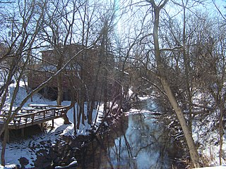
Crooked Lake Outlet Historic District is a national historic district located near Penn Yan in Yates County, New York. The district is located along a seven-mile recreational trail that parallels the Keuka Lake Outlet. The district includes several mill sites along the gorge. It also includes nine areas that contain surface and subsurface archaeological remains.
Mays Point is a hamlet in the Town of Tyre, Seneca County, New York, United States, near the Wayne and Cayuga county lines. It is located seven miles (11 km) northeast of the hamlet of Seneca Falls, at an elevation of 381 feet (116 m). The primary intersection in the hamlet is at N.Y. Route 89 and Mays Point Road. Mays Point is situated along the Erie Canal near the junction of the Seneca and Clyde rivers within the Montezuma Marsh. The New York State Thruway passes just south of the hamlet.
Keuka Lake Outlet is a river located in Yates County, New York. It drains Keuka Lake and flows into Seneca Lake by Dresden, New York. The Crooked Lake Canal was developed along the route of the river. The canal was later replaced by a railroad which is now a hiking and cycling trail, the Keuka Outlet Trail.
References
- 1 2 3 "Keuka Lake Outlet Trail". Footprintpress.com. Archived from the original on 2016-04-14. Retrieved 2016-04-20.
- ↑ /data=!4m5!3m4!1s0x89d0e43214ebc2d3:0xb2c29ec9cf2e91d3!8m2!3d42.6609026!4d-77.0538577 Google Maps,
- ↑ "Along the Outlet of Keuka Lake: The Crooked Lake Canal, Part One by Frances Dumas".
- ↑ "Keuka Outlet Trail History" . Retrieved 21 November 2020.