
Hilton is a village and civil parish in the borough of Stockton-on-Tees and the ceremonial county of North Yorkshire, England. It is a small village with an estimated population of around 400, measured at 374 in the 2011 census. Despite its proximity to Teesside, the village retains its rural feel, and has a number of public footpaths surrounding it.

Angram Grange is a small civil parish in the Hambleton district of North Yorkshire, England, about 7 miles south-east of Thirsk. According to the 2001 census it had a population of 17. In 2015 the population was estimated at 20.

Birkby is a village and civil parish about 6 miles north of the county town of Northallerton in the Hambleton district of North Yorkshire, England. The population of the parish was estimated at 40 in 2010. At the 2011 Census the population was seen to have remained at less than 100. Details were included in the neighbouring civil parish of Deighton, Hambleton.

Burton-on-Yore is a civil parish in the Harrogate district of North Yorkshire, England, facing Masham across the River Ure. There is no village in the parish, but there are two hamlets, Low Burton and High Burton. The parish also includes Nutwith Cote on the west bank of the Ure, between Masham and Grewelthorpe. The population of the parish was estimated at 80 in 2012.

Byland with Wass is a civil parish in the Ryedale district of North Yorkshire, England. According to the 2001 census it had a population of 120, increasing to an estimated 160 in 2015. It covers Byland Abbey and Wass, in the North York Moors, and shares a parish council with Oldstead.
Caldbergh with East Scrafton is a civil parish in the Richmondshire district of North Yorkshire, England. The parish includes the settlements of Caldbergh and East Scrafton.

Brough with St. Giles is a village and a civil parish in the Richmondshire district of North Yorkshire, England. The civil parish also includes the settlements of Catterick Bridge and Walkerville, and Catterick Racecourse and the site of the Roman town of Cataractonium. According to the 2001 Census the parish had a population of 338, increasing to 801 at the 2011 census.

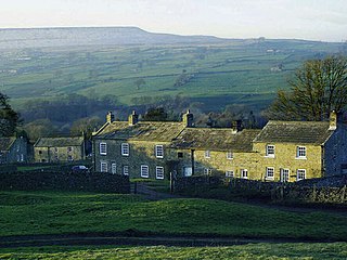
Conistone is a small village in the Craven district of North Yorkshire, England. It lies 3 miles (5 km) north of Grassington, 3 miles (5 km) south of Kettlewell and 12 miles (19 km) north of Skipton beside the River Wharfe, in Upper Wharfedale.

Hood Grange is a hamlet and civil parish in the Hambleton district of North Yorkshire, England. The population of the parish was estimated at 10 in 2010. The population remained at less than 100 in the 2011 Census. Details are included in the civil parish of Sutton-under-Whitestonecliffe. It is located near Thirsk at the foot of Sutton Bank, south of the larger village of Sutton-under-Whitestonecliffe. It is notable for consisting of only a single household after its population decreased rapidly in the late 19th century. Hood Grange has existed as a civil parish since 1866, prior to which the area was part of Kilburn. A monastery known as Hood Abbey existed here from before 1138 until its dissolution in the 16th century.
Maltby is a village and civil parish in the borough of Stockton-on-Tees and ceremonial county of North Yorkshire, England. It is located to the east of the A19. The population of the civil parish taken at the 2011 census was 293.

Middlesbrough Council, formerly known as Middlesbrough Borough Council is the local council of Middlesbrough. It is a unitary authority and borough council in the Tees Valley sub-region of the North East of England. It is based on the town of Middlesbrough, which is often considered to spread outside the borough boundaries into neighbouring Redcar and Cleveland with a total built-up population of 174,700; the borough extends southwards to a semi-rural area. Whilst part of North Yorkshire for ceremonial purposes, it is in the region of North East England. It had a resident council population in 2001 of 134,855. A 2006 mid-year estimate suggests the Borough to have a population of 138,400. The borough council unsuccessfully bid to achieve city status in 2012, to celebrate the Queen's Diamond Jubilee.
Coverham with Agglethorpe is a civil parish in Richmondshire district of North Yorkshire, England. It includes the villages of Coverham and Agglethorpe. The population of the civil parish was estimated at 90 in 2015.
Conistone with Kilnsey is a civil parish in Wharfedale in the district of Craven, North Yorkshire, England. It contains the villages of Kilnsey and Conistone. The population of this civil parish at the 2011 Census was 124 with an estimated population of 110 in 2015.
Sexhow is a hamlet and civil parish in Hambleton district of North Yorkshire, England. The name of the hamlet derives from Old Norse of either sexhou or sekkshaughr, which means the hill of Sekk, a personal name. The population taken at the 2011 Census was less than 100, so details of the population are included on the civil parish of Potto. However, in 2015, North Yorkshire County Council estimated the population to be 20. It is on the River Leven and 5 miles (8 km) west of Stokesley.

Castley is a village and civil parish in the Harrogate district of North Yorkshire, England. It lies on the River Wharfe about 10 miles north of the centre of Leeds. The population of the civil parish was estimated at 70 in 2015.

Lindley is a village and civil parish in the Harrogate district of North Yorkshire, England. It is near Lindley Wood Reservoir and 1 mile north of Otley. In 2001 the population of the civil parish of Lindley was 52. The population was estimated at 50 in 2015.
Hartwith cum Winsley is a civil parish in Harrogate district, North Yorkshire, England. Historically it was a township in the ancient parish of Kirkby Malzeard in the West Riding of Yorkshire, a detached part of that parish. It became a separate civil parish in 1866, and was transferred to North Yorkshire in 1974.
Norton Conyers is a civil parish in North Yorkshire, England, 3 miles (5 km) north of Ripon. There is no modern village in the parish. Most of the parish is occupied by the grounds of Norton Conyers House, which cover the site of a deserted medieval village.

New Forest is a civil parish in the Richmondshire district of North Yorkshire, England. It lies 6 miles (10 km) west of Richmond.
Low Abbotside is a civil parish in the Richmondshire district of North Yorkshire, England. It is a rural parish on the north side of Wensleydale. There is no village in the parish. The population was estimated at 110 in 2012.
