In aviation, instrument flight rules (IFR) is one of two sets of regulations governing all aspects of civil aviation aircraft operations; the other is visual flight rules (VFR).
The Federal Aviation Regulations (FARs) are rules prescribed by the Federal Aviation Administration (FAA) governing all aviation activities in the United States. The FARs comprise Title 14 of the Code of Federal Regulations (CFR). A wide variety of activities are regulated, such as aircraft design and maintenance, typical airline flights, pilot training activities, hot-air ballooning, lighter-than-air aircraft, man-made structure heights, obstruction lighting and marking, model rocket launches, commercial space operations, model aircraft operations, Unmanned Aircraft Systems (UAS) and kite flying. The rules are designed to promote safe aviation, protecting pilots, flight attendants, passengers and the general public from unnecessary risk.
Aviation is the design, development, production, operation, and use of aircraft, especially heavier-than-air aircraft. Articles related to aviation include:
The basic principles of air navigation are identical to general navigation, which includes the process of planning, recording, and controlling the movement of a craft from one place to another.
Piloting or pilotage is the process of navigating on water or in the air using fixed points of reference on the sea or on land, usually with reference to a nautical chart or aeronautical chart to obtain a fix of the position of the vessel or aircraft with respect to a desired course or location. Horizontal fixes of position from known reference points may be obtained by sight or by radar. Vertical position may be obtained by depth sounder to determine depth of the water body below a vessel or by altimeter to determine an aircraft's altitude, from which its distance above the ground can be deduced. Piloting a vessel is usually practiced close to shore or on inland waterways. Pilotage of an aircraft is practiced under visual meteorological conditions for flight.

A navigator is the person on board a ship or aircraft responsible for its navigation. The navigator's primary responsibility is to be aware of ship or aircraft position at all times. Responsibilities include planning the journey, advising the ship's captain or aircraft commander of estimated timing to destinations while en route, and ensuring hazards are avoided. The navigator is in charge of maintaining the aircraft or ship's nautical charts, nautical publications, and navigational equipment, and they generally have responsibility for meteorological equipment and communications. With the advent of satellite navigation, the effort required to accurately determine one's position has decreased by orders of magnitude, so the entire field has experienced a revolutionary transition since the 1990s with traditional navigation tasks, like performing celestial navigation, being used less frequently. Using multiple independent position fix methods without solely relying on electronic systems subject to failure helps the navigator detect errors. Professional mariners are still proficient in traditional piloting and celestial navigation.

A private pilot licence (PPL) or private pilot certificate is a type of pilot licence that allows the holder to act as pilot in command of an aircraft privately. The basic licence requirements are determined by the International Civil Aviation Organization (ICAO), but implementation varies from country to country. According to ICAO, an applicant must be at least 17 years old, demonstrate appropriate knowledge and skill, and hold at least a Class 2 medical certificate. Different PPLs are available for different categories of aircraft, such as aeroplane, helicopter, airship, etc, and are not interchangeable, although experience from a PPL in one category may be credited towards the issue of another.
A commercial pilot licence (CPL) is a type of pilot licence that permits the holder to act as a pilot of an aircraft and be paid for their work.
In aviation, lowest safe altitude (LSALT) is an altitude that is at least 500 feet above any obstacle or terrain within a defined safety buffer region around a particular route that a pilot might fly. The safety buffer allows for errors in the air by including an additional area that a pilot might stray into by flying off track. By flying at or above this altitude a pilot complies with terrain clearance requirements on that particular flight leg.

The Convention on International Civil Aviation, also known as the Chicago Convention, established the International Civil Aviation Organization (ICAO), a specialized agency of the United Nations charged with coordinating international air travel. The Convention establishes rules of airspace, aircraft registration and safety, security, and sustainability, and details the rights of the signatories in relation to air travel. The convention also contains provisions pertaining to taxation.

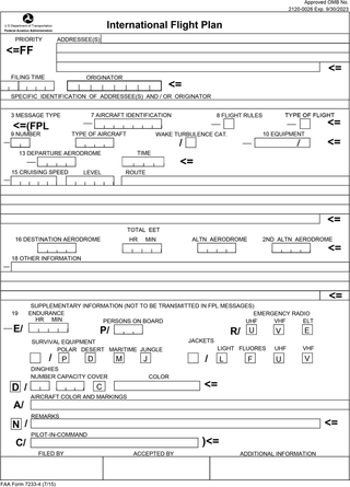
Flight plans are documents filed by a pilot or flight dispatcher with the local Air Navigation Service Provider prior to departure which indicate the plane's planned route or flight path. Flight plan format is specified in ICAO Doc 4444. They generally include basic information such as departure and arrival points, estimated time en route, alternate airports in case of bad weather, type of flight, the pilot's information, number of people on board, and information about the aircraft itself. In most countries, flight plans are required for flights under IFR, but may be optional for flying VFR unless crossing international borders. Flight plans are highly recommended, especially when flying over inhospitable areas such as water, as they provide a way of alerting rescuers if the flight is overdue. In the United States and Canada, when an aircraft is crossing the Air Defense Identification Zone (ADIZ), either an IFR or a special type of VFR flight plan called a DVFR flight plan must be filed. For IFR flights, flight plans are used by air traffic control to initiate tracking and routing services. For VFR flights, their only purpose is to provide needed information should search and rescue operations be required, or for use by air traffic control when flying in a "Special Flight Rules Area."
Pilot licensing or certification refers to permits for operating aircraft. Flight crew licences are issued by the civil aviation authority of each country, which must establish that the holder has met minimum knowledge and experience before issuing licences. The licence, along with the required class or type rating, allows a pilot to fly aircraft registered in the licence issuing state.

Pilot certification in the United States is typically required for an individual to act as a pilot-in-command of an aircraft. It is regulated by the Federal Aviation Administration (FAA), a branch of the U.S. Department of Transportation (USDOT). A pilot may be certified under 14 Code of Federal Regulations (CFR) Part 61 or 14 CFR Part 141. Pilots may also be certified under 14 CFR Part 107 for commercial drone operations.
Pilot licensing in the United Kingdom is regulated by the Civil Aviation Authority (CAA).
An instrument rating is an authorization required for a pilot to fly under instrument flight rules (IFR). In the United States, the rating is issued by the Federal Aviation Administration.

In aviation, an instrument approach or instrument approach procedure (IAP) is a series of predetermined maneuvers for the orderly transfer of an aircraft operating under instrument flight rules from the beginning of the initial approach to a landing, or to a point from which a landing may be made visually. These approaches are approved in the European Union by EASA and the respective country authorities and in the United States by the FAA or the United States Department of Defense for the military. The ICAO defines an instrument approach as, "a series of predetermined maneuvers by reference to flight instruments with specific protection from obstacles from the initial approach fix, or where applicable, from the beginning of a defined arrival route to a point from which a landing can be completed and thereafter, if landing is not completed, to a position at which holding or en route obstacle clearance criteria apply."
An aeronautical chart is a map designed to assist in the navigation of aircraft, much as nautical charts do for watercraft, or a roadmap does for drivers. Using these charts and other tools, pilots are able to determine their position, safe altitude, best route to a destination, navigation aids along the way, alternative landing areas in case of an in-flight emergency, and other useful information such as radio frequencies and airspace boundaries. There are charts for all land masses on Earth, and long-distance charts for trans-oceanic travel.

In aviation, V-speeds are standard terms used to define airspeeds important or useful to the operation of all aircraft. These speeds are derived from data obtained by aircraft designers and manufacturers during flight testing for aircraft type-certification. Using them is considered a best practice to maximize aviation safety, aircraft performance, or both.

A pilot logbook is a record of a pilot's flying hours. It contains every flight a pilot has flown, including flight time, number of landings, and types of instrument approaches made. Pilots also log simulator time, as it counts towards training.
A night rating permits an aircraft pilot to fly at night under visual flight rules. The alternative is flight by instrument flight rules (IFR), under which visual reference to terrain and traffic is not required.


