
Uintah County is a county in the U.S. state of Utah. As of the 2010 United States Census the population was 32,588. Its county seat and largest city is Vernal. The county was named for the portion of the Ute Indian tribe that lived in the basin.

Mesa County is a county located in the U.S. state of Colorado. As of the 2020 census, the population was 155,703. The county seat is Grand Junction. The county was named for the many large mesas in the area, including Grand Mesa.

The City of Westminster is a home rule municipality located in Adams and Jefferson counties, Colorado, United States. The city population was 116,317 at the 2020 United States Census with 71,240 residing in Adams County and 45,077 residing in Jefferson County. Westminster is the eighth most populous city in Colorado. The city is a part of the Denver–Aurora–Lakewood, CO Metropolitan Statistical Area and the Front Range Urban Corridor. The Westminster Municipal Center is located 9 miles (14 km) north-northwest of the Colorado State Capitol in Denver.

The Town of Cedaredge is a home rule municipality located in Delta County, Colorado, United States. The town population was 2,279 at the 2020 United States Census. Cedaredge sits in the Surface Creek Valley beneath the southern slopes of the Grand Mesa, the largest mesa in the world. Its elevated vantage point affords southern views of the San Juan Mountains, the Black Canyon of the Gunnison National Park, and the communities of Delta, Olathe, and Montrose. Cedaredge is a small, agricultural community which produces beef cattle, elk, apples, peaches, and wine from the region's few basic vineyards. Tourist attractions include Cedaredge Golf Club, Historic Pioneer Town, and an art gallery and craft store housed in a renovated apple packing shed. Regional sporting activities include camping, trophy hunting, hiking and Gold Medal fishing at more than 250 lakes on the Grand Mesa. During the winter locals partake in snowmobiling and Nordic skiing on the Mesa's trails. Powderhorn Resort is located 30 miles (48 km) north of Cedaredge and has ski terrain such as groomers, bumps, glades, and boulder fields, as well as two terrain parks.
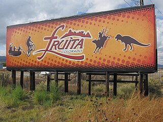
The City of Fruita is a home rule municipality located in western Mesa County, Colorado, United States. The city population was 13,395 at the 2020 United States Census. Fruita is a part of the Grand Junction, CO Metropolitan Statistical Area and lies within the Grand Valley. The geography is identified by the bordering Colorado River on the southern edge of town, the Uncompahgre Plateau known for its pinyon-juniper landscape, and the Book Cliffs range on the northern edge of the Grand Valley. Originally home to the Ute people, white farmers settled the town after founder William Pabor in 1884. Ten years later, Fruita was incorporated.

Grand Junction is a home rule municipality that is the county seat and the most populous municipality of Mesa County, Colorado, United States. The city population was 65,560 at the 2020 United States Census, making Grand Junction the 17th most populous Colorado municipality and the most populous city in western Colorado.

Loma is an unincorporated town, a post office, and a census-designated place (CDP) located in and governed by Mesa County, Colorado, United States. The CDP is a part of the Grand Junction, CO Metropolitan Statistical Area. The Loma post office has the ZIP Code 81524. At the United States Census 2010, the population of the Loma CDP was 1,293, while the population of the 81524 ZIP Code Tabulation Area was 2,300 including adjacent areas.

Brogdale is a hamlet in Kent, England, immediately south of the M2 motorway, 2 miles (3.2 km) south of Faversham. It is one of several hamlets making up the civil parish of Ospringe and is in the Borough of Swale. Its western half is in the Kent Downs Area of Outstanding Natural Beauty.
Heritage Park Historical Village is a historical park in Calgary, Alberta, Canada, on 127 acres (51 ha) of parkland on the banks of the Glenmore Reservoir, along the city's southwestern edge. As Canada's second largest living history museum, it is one of the city's most visited tourist attractions. Exhibits span western Canadian history from the 1860s to the 1950s. Many of the buildings are historical and were transported to the park to be placed on display. Others are re-creations of actual buildings. Most of the structures are furnished and decorated with genuine artifacts. Staff dress in historic costume, and antique automobiles and horse-drawn vehicles service the site. Calgary Transit provides regular shuttle service from Heritage C-Train station. The park opened on July 1, 1964.
The Dominion Atlantic Railway was a historic railway which operated in the western part of Nova Scotia in Canada, primarily through an agricultural district known as the Annapolis Valley.
The Colorado Railroad Museum is a non-profit railroad museum. The museum is located on 15 acres (6.1 ha) at a point where Clear Creek flows between North and South Table Mountains in Golden, Colorado.
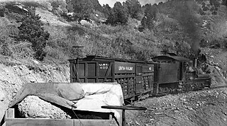
The Uintah Railway was a small 3 ft narrow gauge railroad company in Utah and Colorado in the United States. It was constructed to carry Gilsonite which provided most of its operating revenues; but it operated as a common carrier from 1904 to 1939, also carrying passengers, mail, express, and other cargoes including sheep and wool. When a public library was built in Dragon in 1910, the Uintah Railway agreed to deliver library books free of charge to and from any borrower along its route. Many area ranchers and miners took advantage of the opportunity.
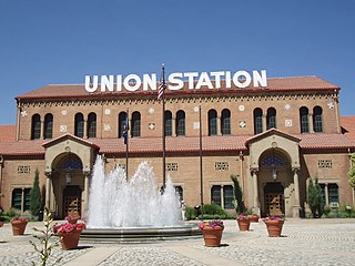
Union Station, also known as Ogden Union Station, is a train station in Ogden, Utah, at the west end of Historic 25th Street, just south of the Ogden Intermodal Transit Center. Formerly the junction of the Union Pacific and Central Pacific Railroads, its name reflects the common appellation of train stations whose tracks and facilities are shared by railway companies.

Laws is an unincorporated community in Inyo County, California. Laws is located 4 miles (6.4 km) northeast of Bishop on U.S. Route 6, towards the Nevada state line.

The Ute Indian Tribe of the Uinta and Ouray Reservation is a Federally Recognized Tribe of Indians in northeastern Utah, United States. Three bands of Utes comprise the Ute Indian Tribe: the Whiteriver Band, the Uncompahgre Band and the Uintah Band. The Tribe has a membership of more than three thousand individuals, with over half living on the Uintah and Ouray Indian Reservation. The Ute Indian Tribe operates its own tribal government and oversees approximately 1.3 million acres of trust land which contains significant oil and gas deposits.

The Grand Valley AVA is an American Viticultural Area located in Mesa County, Colorado, primarily in Grand Junction and Palisade. It is located roughly 200 miles West-Southwest of Denver. The high-desert AVA - with an average elevation of between 4,000 and 5,000 feet above sea level - is defined by the irrigated agricultural area served via canals within the Grand Valley of the Colorado River. The AVA was established in 1991 as the first of two Colorado wine regions. The West Elks AVA is the second federally designated AVA in Colorado.

The Dinosaur Diamond is a 486-mile (782 km) scenic and historic byway loop through the dinosaur fossil laden Uinta Basin of the U.S. states of Utah and Colorado. The byway comprises the following two National Scenic Byways:
The Trail of the Ancients is a collection of National Scenic Byways located in the U.S. Four Corners states of Utah, Colorado, New Mexico, and Arizona. These byways comprise:
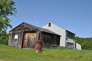
Lamson Farm is a historic farm property on Lamson Road in Mont Vernon, New Hampshire. Founded in the 1770s and operated as a farm until 1975, it is one of the few surviving intact 19th-century farm properties in the community. Its land, over 300 acres (120 ha) in size, is now town-owned conservation and farmland. The property has trails open to the public, and an annual celebration of Lamson Farm Day is held here every September. The property was added to the National Register of Historic Places in 1981.

