
The Borough of Scarborough is a non-metropolitan district and borough of North Yorkshire, England. In addition to the town of Scarborough, it covers a large stretch of the coast of Yorkshire, including Whitby and Filey. It borders Redcar and Cleveland to the north, the Ryedale and Hambleton districts to the west and the East Riding of Yorkshire to the south.

Urpeth is a village in County Durham, England. It is situated a short distance from Ouston and Beamish, near the border with Tyne and Wear. The parish population taken at the 2011 census was 3,630.

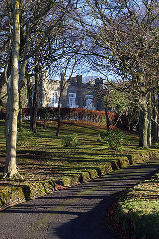
Ingleton is a village and civil parish in County Durham, England. The population of the parish as taken at the 2011 census was 420. It is situated about eight miles to the west of Darlington, and a short distance from the villages of Langton, Hilton and Killerby. The Church of St John the Evangelist in Ingleton was built in 1843 by Ignatius Bonomi and J.A. Cory., and is a Grade II listed building.

Great Lumley is a village in County Durham, England. It is situated south east of Chester-le-Street, near Lumley Castle. It has a population of 3,843, reducing to 3,684 at the 2011 census.
Cornsay Colliery is a village in County Durham, England. It is situated a few miles to the west of Durham, close to Cornsay, Quebec and Esh Winning.

The A64 is a major road in North and West Yorkshire, England, which links Leeds, York and Scarborough. The A64 starts as the A64(M) ring road motorway in Leeds, then towards York it becomes a high-quality dual carriageway until it is east of York, where it becomes a single carriageway for most of its route to Scarborough.

Grosmont is a village and civil parish situated in Eskdale in the North York Moors National Park, within the boundaries of the Scarborough district of the county of North Yorkshire, England.
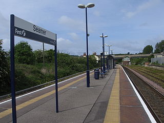
Seamer railway station serves the village of Seamer in North Yorkshire, England. It lies near the end of the Scarborough branch on the TransPennine Express North TransPennine route, 39 miles (63 km) east of York at its junction with the northern end of the Yorkshire Coast Line. Seamer station is managed by TransPennine Express, with services being run by both Northern Trains and TransPennine Express.
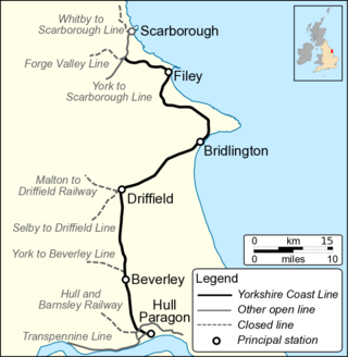
The Hull–Scarborough line, also known as the Yorkshire Coast Line, is a minor railway line in northern England used primarily for passenger traffic. It runs northwards from Hull Paragon via Beverley and Driffield to Bridlington, joining the York–Scarborough line at a junction near Seamer before terminating at Scarborough railway station.
Houghall [pron: /ˈhɒfl/] is a hamlet in County Durham, in England. It is situated approximately 1.5 miles (2.4 km) to the south of Durham city centre. It is also the location of the Houghall Campus of East Durham College, associated gardens, a small number of houses and a restaurant.

Seamer is a village and civil parish in the Scarborough district of North Yorkshire, England. It was the location of the Mesolithic Age settlement of Star Carr.

Kirby Sigston is a village and civil parish in the Hambleton district of North Yorkshire, England, approximately 4 miles (6.4 km) east of Northallerton. The village is situated on the Cod Beck river, and the wider parish contains the hamlet of Jeater Houses due east of the village on the trunk A19 road. The village is mentioned in the Domesday Book of 1086 as having 75 ploughlands, and its name derives from a combination of the Old Norse Kirkju-býr and Sigges tūn. Sigston is also the name of a village nearby.
Woodlesford is a suburban village in the City of Leeds, West Yorkshire, England, 6 miles (10 km) south-east of Leeds city centre. Formerly part of the Rothwell Urban District, it is now within the Rothwell ward of Leeds City Council. The village sits on the banks of the Aire and Calder Navigation and river system.

North Marine Road Ground, formerly known as Queen's, is a cricket ground in Scarborough, North Yorkshire, England. It is the home of Scarborough Cricket Club which hosts the Scarborough Festival and the Yorkshire County Cricket Club plays a series of fixtures in the second half of the season each year. The current capacity is 11,500, while its record attendance is the 22,946 who watched Yorkshire play Derbyshire in 1947. The two ‘ends’ are known as the Peasholm Park End and the Trafalgar Square End.
Staxton is a village in the Ryedale district of North Yorkshire, England, part of the civil parish of Willerby, and situated approximately 8.2 miles from Scarborough town centre. Until 1974 the village lay in the historic county boundaries of the East Riding of Yorkshire.
Greeba Castle is a castle on the Isle of Man.

Highlander is situated between the 5th and 6th Milestone road-side markers on the Snaefell Mountain Course used for the Isle of Man TT races on the primary A1 Douglas to Peel road in the parish of Marown in the Isle of Man.

Llanbadarn Fawr is a community in Powys, within the historic boundaries of Radnorshire, mid Wales. Consisting of a tract of undulating land directly north east of Llandrindod Wells, the community consists of the settlements of Crossgates and Fron and in 2001 had a population of 654, increasing to 701 at the 2011 Census. The community name comes from the local church.
South Street is an affluent residential street in Durham, England, on the banks of the River Wear. It overlooks the Durham Cathedral, a UNESCO World Heritage Site, and Durham Castle. It is best known for its terraced houses, many of which are Grade II listed buildings built in the Tudor Revival architecture and architecture of the modern era.
Humbug Park also previously known as Crossgates Greyhound Stadium is a football ground and former greyhound racing track on Inverkeithing Road in Crossgates, Fife, Scotland.
