
North Kingstown is a town in Washington County, Rhode Island, United States, and is part of the Providence metropolitan area. The population was 27,732 in the 2020 census. North Kingstown is home to the birthplace of American portraitist Gilbert Stuart, who was born in the village of Saunderstown. Within the town is Quonset Point, location of the former Naval Air Station Quonset Point, known for the invention of the Quonset hut, as well as the historic village of Wickford.

Peace Dale is a village in the town of South Kingstown, Rhode Island, United States. Together with the village of Wakefield, it is treated by the U.S. Census as a component of the census-designated place identified as Wakefield-Peacedale.

Wickford is a small village in the town of North Kingstown, Rhode Island, United States, which is named after Wickford in Essex, England. Wickford is located on the western side of Narragansett Bay, just about a 20-minute drive across two bridges from Newport, Rhode Island. The village is built around one of the most well-protected natural harbors on the eastern seaboard, and features one of the largest collections of 18th century dwellings to be found anywhere in the Northeast. Today, the majority of the village's historic homes and buildings remain largely intact upon their original foundations.

Saunderstown is a small village and historic district in the towns of Narragansett and North Kingstown in Washington County, Rhode Island, United States. It was named in honor of John Aldrich Saunders, a member of the Saunders family. Saunderstown has its own post office with the ZIP Code of 02874, which also includes a small part of South Kingstown. Its population is 6,245.

The Isaac Bell House is a historic house and National Historic Landmark at 70 Perry Street in Newport, Rhode Island. Also known as Edna Villa, it is one of the outstanding examples of Shingle Style architecture in the United States. It was designed by McKim, Mead, and White, and built during the Gilded Age, when Newport was the summer resort of choice for some of America's wealthiest families.
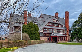
The William Watts Sherman House is a notable house designed by American architect H. H. Richardson, with later interiors by Stanford White. It is a National Historic Landmark, generally acknowledged as one of Richardson's masterpieces and the prototype for what became known as the Shingle Style in American architecture. It is located at 2 Shepard Avenue, Newport, Rhode Island and is now owned by Salve Regina University. It is a contributing property to the Bellevue Avenue Historic District.
The Bellevue Avenue Historic District is located along and around Bellevue Avenue in Newport, Rhode Island, United States. Its property is almost exclusively residential, including many of the Gilded Age mansions built as summer retreats around the turn of the 20th century by the extremely wealthy, including the Vanderbilt and Astor families. Many of the homes represent pioneering work in the architectural styles of the time by major American architects.

The shingle style is an American architectural style made popular by the rise of the New England school of architecture, which eschewed the highly ornamented patterns of the Eastlake style in Queen Anne architecture. In the shingle style, English influence was combined with the renewed interest in Colonial American architecture which followed the 1876 celebration of the Centennial. The plain, shingled surfaces of colonial buildings were adopted, and their massing emulated.
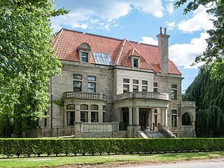
Charles H. Baldwin House is a historic house on Bellevue Avenue in Newport, Rhode Island, United States, that is part of the Bellevue Avenue Historic District, but is individually listed on the National Register of Historic Places (NRHP).

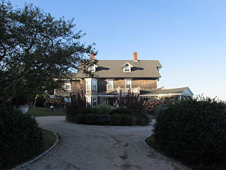
Horsehead/Marbella is an historic summer house at 240 Highland Drive in Jamestown, Rhode Island. Occupying a spectacular setting on a southerly-projecting peninsula, this Shingle style house and carriage house were designed by Charles L. Bevins and built for industrialist Joseph Wharton in the 1880s. It is also notable as an early example of the lower-key architectural styles associated with Jamestown's summer community, differentiating it from the more elaborate summer estates developed in nearby Newport.

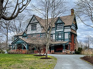
The Lyman C. Josephs House, also known as Louisiana, is a historic home at 438 Wolcott Avenue in Middletown, Rhode Island. Architect Clarence Luce designed the house, which was built in 1882, and is a well-preserved early example of the Shingle style. The house received architectural notice not long after its construction, but is more noted for its relatively modest size and lack of ostentation than the summer houses of nearby Newport. It was built for the Josephs family of Baltimore, Maryland.

Browning's Beach Historic District is a historic district west of the junction between Card Pond and Matunuck Beach Roads in South Kingstown, Rhode Island. It encompasses a cluster of four beach houses located on a barrier beach facing Long Island Sound south of Cards Pond, and accessed via a private gravel drive extending from Cards Pond Road. The four houses, along with several outbuildings, were built in the early years of the 20th century, and are architecturally diverse expressions of Queen Anne, Shingle, and Colonial Revival elements. Typical architectural elements include shingle siding, recessed porches, and chalet-style roofs.

The Davisville Historic District is a historic district on Davisville Road in Davisville, Rhode Island, a village in North Kingstown. It encompasses the site of an early 19th-century mill, and several associated buildings, including five houses dating to the 18th or 19th century and a cemetery. It is located on either side of Davisville Road, between the Hunt River and Olde Mill Lane.
The Ocean Road Historic District is a residential historic district, encompassing an area of fashionable summer houses built in the late 19th and early 20th centuries in Narragansett, Rhode Island. The area is located south of The Towers, the center of the Narragansett Pier area, extending along Ocean Road roughly from Hazard Street to Wildfield Farm Road. Many of the 45 houses in the district were built between about 1880 and 1900, with a few built earlier and later. The Shingle style is prominent in the architectural styles found, including among houses designed by architects, including McKim, Mead & White and William Gibbons Preston. The most unusual property is called Hazard's Castle, a rambling stone structure built beginning in the 1840s by Joseph Peace Hazard, who was a major landowner in the area prior to its development in the 1880s.

The Joseph Pierce Farm is an historic farm at 933 Gilbert Stuart Road in North Kingstown, Rhode Island. It consists of 18 acres (7.3 ha) of land, along with an 18th-century farmhouse and a number of 19th-century outbuildings. The oldest portion of the house, its southern ell, was originally built with a gable roof, but this was extended to the north in the late 18th or early 19th century, and given it present gambrel roof and Federal styling. Later additions in the 19th and 20th centuries gave the house its present cruciform appearance. Outbuildings dating to the 19th century include a barn with attached privy, a toolshed, and a henhouse. The complex is a well-preserved reminder of the area's rural heritage.

The Esbon Sanford House is an historic house at 88 Featherbed Lane in North Kingstown, Rhode Island. It is a 1+1⁄2-story wood-frame structure, five bays wide, with a central chimney and simple Federal-Greek Revival transitional styling. The main entry, centered on the front facade, is framed by small sidelight windows and pilasters, and is topped by an entablature. The most unusual feature of the house relates to its chimney: despite its central location, the interior of the house is organized in a central hall plan, with the flues of the flanking chambers rising at an angle and joining in the attic space to form the single chimney seen outside. The house was probably built in 1832 by Esbon Sanford, who established a textile mill nearby that same year.

The Spink Farm is a historic farm at 1325 Shermantown Road in North Kingstown, Rhode Island. The only surviving element of the farmstead on this 55-acre (22 ha) farm is the main house, a 2+1⁄2-story five-bay wood-frame structure built in 1798 by Isaac Spink. The house exhibits modest Federal styling, its doorway flanked by small sidelight windows and simple pilasters, and topped by a shallow hood. The interior follows a typical center-chimney plan, with its original Federal period fireplace mantels intact. The house has been extended to the rear by a kitchen ell and porch, both added in the 20th century. The house is one of a small number of 18th-century farmsteads left in the town.

The Tootell House is a house at 1747 Mooresfield Road in Kingston, Rhode Island that is listed on the National Register of Historic Places.

The Kent County Courthouse, now the East Greenwich Town Hall, is a historic court building at 127 Main Street in East Greenwich, Rhode Island.

The Shoreby Hill Historic District encompasses a major residential subdivision north of the central business district of Jamestown, Rhode Island. The 58-acre (23 ha) district was farmland until the late 19th century, and was laid out in two phases. The first, in 1898 includes the lower portion of the area, rising from the shore of Jamestown Harbor; the upper portion was laid out in 1911. The lower portion's layout is in part determined by its hill topography, with winding roads, while the upper portion has a more rectilinear grid street pattern. The district is roughly bounded on the east by Jamestown Harbor, on the north by Emerson Road, Prudence Lane, and Whittier Road, on the west by Plymouth Road, and Coronado Street, and on the south by Knowles Court. The area was designed by Ernest W. Bowditch as an exclusive and fashionable summer resort area, with larger houses on well-proportioned lots. The ninety houses in the district are predominantly shingle style.


