
The London Borough of Croydon is a London borough in south London, part of Outer London. It covers an area of 87 km2 (33.6 sq mi). It is the southernmost borough of London. At its centre is the historic town of Croydon from which the borough takes its name; while other urban centres include Coulsdon, Purley, South Norwood, Norbury, New Addington and Thornton Heath. Croydon is mentioned in Domesday Book, and from a small market town has expanded into one of the most populous areas on the fringe of London. The borough is now one of London's leading business, financial and cultural centres, and its influence in entertainment and the arts contribute to its status as a major metropolitan centre. Its population is 386,710, making it the second largest London borough and fifteenth largest English district.

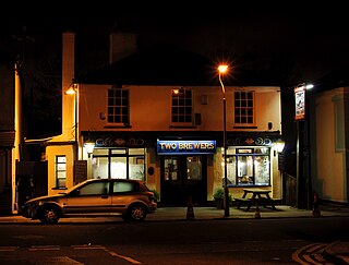
Croydon is a large town in south London, England. It is 9.4 miles (15.1 km) south of Charing Cross. The principal settlement in the London Borough of Croydon, it is one of the largest commercial districts in Greater London outside Central London, with an extensive shopping district and night-time economy. The entire town had a population of 192,064 as of 2011, whilst the wider borough had a population of 384,837.

East Croydon is a railway station and tram stop in the town of Croydon, Greater London, England, and is located in Travelcard Zone 5. At 10 miles 28 chains from London Bridge, it is one of the busiest non-terminal stations in London, and in the United Kingdom as a whole. It is one of three railway stations in the London Borough of Croydon with Croydon in their name, the others being West Croydon and South Croydon. A Tramlink tram stop is located immediately outside the main station entrance.

South Norwood Country Park is a park in South Norwood, close to Elmers End and Birkbeck train stations. The historic Kent-Surrey border runs through the site, and since 1965 it has been located wholly in the London Borough of Croydon. It is a 47 hectare green space which opened in 1989. The park is a mix of countryside and parkland, and land formerly used for sewage farms serving the growing London population.

South Norwood is a district of south-east London, England, within the London Borough of Croydon and the historic county of Surrey. It is located 7.8 miles (12.5 km) south-east of Charing Cross, north of Woodside and Addiscombe, east of Selhurst and Thornton Heath, south of Crystal Palace/Upper Norwood and Anerley, and west of Elmers End and Penge.

West Croydon is a combined railway, bus station and tram stop in Croydon, south London. It is served by National Rail, London Overground, Tramlink and London Buses services and is in Travelcard Zone 5.
South Croydon in south London is the area surrounding the valley south of central Croydon and running as far south as the former Red Deer public house on the Brighton Road. It is bounded by Waddon to the West and Selsdon and Sanderstead to the East. It is part of the South Croydon (CR2) post town and in the London Borough of Croydon. It is essentially a dormitory suburb for Croydon and London.
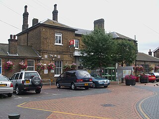
Norwood Junction railway station is a National Rail station in South Norwood in the London Borough of Croydon, south London and is in Travelcard Zone 4. It is 8 miles 55 chains (13.98 km) down the line from London Bridge.

Croydon Park is a suburb in the Inner West of Sydney, in the state of New South Wales, Australia. Croydon Park is 10 kilometres south-west of the Sydney central business district and is divided between the local government areas of the City of Canterbury-Bankstown, Municipality of Burwood and Inner West Council. Croydon is a separate suburb, to the north.

The London Borough of Croydon has over 120 parks and open spaces within its boundaries, ranging from the 200 acre (80ha) Selsdon Wood Nature Reserve to many recreation grounds and sports fields scattered throughout the Borough. Croydon covers an area of 86.52 km², the 256th largest district in England. Croydon's physical features consist of many hills and rivers that are spread out across the borough and into the North Downs, Surrey and the rest of South London. Some of the open spaces in Croydon form part of the well-known London LOOP walks where the first section was opened on 3 May 1996 with a ceremony on Farthing Downs in Coulsdon. As a borough in Outer London it also contains some open countryside in the form of country parks. Croydon Council is associated with several other boroughs who are taking part in the Downlands Countryside Management Project. These boroughs are Sutton; and by Surrey County Council; the City of London Corporation; the Surrey districts of Reigate and Banstead and Tandridge; and the Countryside Agency. An additional partner is Natural Britain.
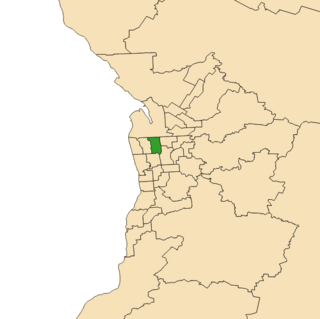
Croydon is a single-member electoral district for the South Australian House of Assembly. Named after the suburb of Croydon, it is a 18.78 km2 (7.25 sq mi) suburban electorate in Adelaide's inner north-west. In addition to Croydon, it includes Angle Park, Athol Park, Bowden, Brompton, Croydon Park, Devon Park, Dudley Park, Ferryden Park, Kilkenny, Mansfield Park, Regency Park, Renown Park, Ridleyton, West Croydon, Woodville Gardens; and parts of Allenby Gardens, Welland, and West Hindmarsh.
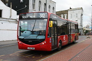
London Buses route 312 is a Transport for London contracted bus route in London, England. Running between South Croydon garage and Norwood Junction station, it is operated by Arriva London.
Selhurst is a London suburb in the Borough of Croydon 7.8 miles (12.6 km) south-south-east of Charing Cross. Historically it lay in Surrey. The area is bounded to the west and south by Thornton Heath and Croydon and to the east and south by South Norwood and Woodside. The home stadium of Crystal Palace Football Club, called Selhurst Park, is sited at the northern end of the neighbourhood.
Ashfield was an electoral district of the Legislative Assembly in the Australian state of New South Wales, first created in 1894 with the abolition of multi-member electoral districts from part of Canterbury, and named after the Sydney suburb of Ashfield. It was abolished in 1920, with the introduction of proportional representation and absorbed into Western Suburbs. It was recreated in 1927 and, in 1959, it was partly combined with Croydon and renamed Ashfield-Croydon. In 1968, Ashfield-Croydon was replaced by Ashfield, which was abolished again in 1999.
Croydon was an electoral district of the Legislative Assembly in the Australian state of New South Wales, created in 1927, with the abolition of proportional representation from part of the multi-member electorate of Western Suburbs, and named after and including the Sydney suburb of Croydon. It was abolished in 1959 and partly combined with Ashfield to create Ashfield-Croydon.
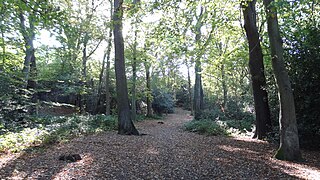
Croham Hurst is a 33.6 hectare biological Site of Special Scientific Interest (SSSI) and a Site of Metropolitan Importance for Nature Conservation in South Croydon in the London Borough of Croydon. Its SSSI designation is due to its importance for nature conservation, but it is also a Regionally Important Geological Site.

The First Periodic Review of Westminster constituencies was a review of constituency boundaries for the Westminster Parliament in the United Kingdom carried out by the Boundary Commissions created by the House of Commons Act 1949. The Commissions reported in 1954 and their recommendations took effect for the 1955 general election. Legal action over the review ultimately resulted in the passage of the House of Commons Act 1958.
Croydon, an electoral district of the Legislative Assembly in the Australian state of New South Wales was created in 1927 and abolished in 1959.
