Related Research Articles
Owain ap Gruffudd was King of Gwynedd, North Wales, from 1137 until his death in 1170, succeeding his father Gruffudd ap Cynan. He was called Owain the Great and the first to be styled "Prince of Wales". He is considered to be the most successful of all the North Welsh princes prior to his grandson, Llywelyn the Great. He became known as Owain Gwynedd to distinguish him from the contemporary king of Powys Wenwynwyn, Owain ap Gruffydd ap Maredudd, who became known as Owain Cyfeiliog.

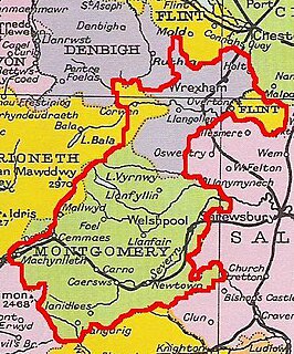
Powys is a county and preserved county in Wales. It is named after the Kingdom of Powys which was a Welsh successor state, petty kingdom and principality that emerged during the Middle Ages following the end of Roman rule in Britain.

The Kingdom of Gwynedd was a Roman Empire successor state that emerged in sub-Roman Britain in the 5th century during the Anglo-Saxon settlement of Britain.

Castell Dinas Brân is a medieval castle occupying a prominent hilltop site above the town of Llangollen in Denbighshire, Wales. The presently visible castle was probably built in the 1260s by Gruffydd Maelor II, a prince of Powys Fadog, on the site of several earlier structures, including an Iron Age hillfort.
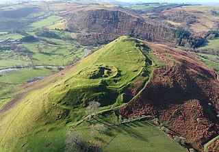
Cefnllys Castle was a medieval spur castle in Radnorshire, Wales. Two successive masonry castles were built on a ridge above the River Ithon known as Castle Bank in the thirteenth century, replacing a wooden motte-and-bailey castle constructed by the Normans nearby. Controlling several communication routes into the highlands of Mid Wales, the castles were strategically important within the Welsh Marches during the High Middle Ages. As the seat of the fiercely contested lordship and cantref of Maelienydd, Cefnllys became a source of friction between Llywelyn ap Gruffudd and Roger Mortimer in the prelude to Edward I's conquest of Wales (1277–1283). Cefnllys was also the site of a borough and medieval town.
Madog ap Maredudd was the last prince of the entire Kingdom of Powys, Wales and for a time held the Fitzalan Lordship of Oswestry.

Maelienydd, sometimes spelt Maeliennydd, was a cantref and lordship in east central Wales covering the area from the River Teme to Radnor Forest and the area around Llandrindod Wells. The area, which is mainly upland, is now in Powys. During the Middle Ages it was part of the region known as Rhwng Gwy a Hafren and its administrative centre was at Cefnllys Castle.

Cwmhir Abbey, near Llandrindod Wells in Powys, is a Welsh Cistercian monastery founded in 1176 by Cadwallon ap Madog. A spurious tale was later recorded that the abbey was founded in 1143 by Meredudd ap Maelgwn at Ty-faenor, and then refounded at the present location near the village of Abbeycwmhir in 1176. There does appear to be a site movement from Ty-faenor, but Maredudd ap Maelgwn was prince of Maelienydd in 1215 under Prince Llywelyn ab Iorwerth of Gwynedd, who then controlled the district. The later charter to the abbey in 1215 caused the confusion and led to the belief that Maredudd had founded the abbey in 1143.

Gwrtheyrnion or Gwerthrynion was a commote in medieval Wales, located in Mid Wales on the north side of the River Wye; its historical centre was Rhayader. It is said to have taken its name from the legendary king Vortigern. For most of the medieval era, it was associated with the cantref of Buellt and then Elfael, small regional kingdoms whose rulers operated independently of other powers. In the Norman era, like the rest of the region between Wye and Severn it came to be dominated by Marcher Lordships.
This article is about the particular significance of the century 1101–1200 to Wales and its people.
Rhwng Gwy a Hafren was a region of medieval Wales, located in the Welsh Marches between Powys to the north and Brycheiniog to the south. It was bounded by the rivers Wye and Severn. It covered about the same territory as Radnorshire, now part of the county of Powys. The region first came into its own in the 9th or 10th centuries, when it was ruled by leaders who operated independently of the surrounding kingdoms. After the Norman invasion, it comprised the central part of the Welsh Marches and was the site of frequent struggles between Welsh and Norman forces.
Cadwallon ap Madog was the son of Madog ab Idnerth who had died in 1140, while Idnerth was a grandson of Elystan Glodrydd who had died in around 1010 and had founded a dynasty in the Middle Marches of Wales, in the area known as Rhwng Gwy a Hafren.

Elfael was one of a number of Welsh cantrefi occupying the region between the River Wye and river Severn, known as Rhwng Gwy a Hafren, in the early Middle Ages. It was divided into two commotes, Is Mynydd and Uwch Mynydd, separated by the chain of hills above Aberedw. In the late medieval period, it was a marcher lordship. However, after the Laws in Wales Act of 1535, it was one of the territorial units which went to make up the county of Radnorshire in 1536.
Elystan Glodrydd, also known as "Æthelstan the Famous" and "The Renowned," was, according to Welsh genealogical tracts, the founder of the fifth Royal Tribe of Wales. He was the Prince of Buellt, and later also of Fferreg ; in the century after his death, Fferreg split into Maelienydd and Elfael
Llanfihangel Nant Melan is a small village in Powys, Wales, in the ancient county of Radnorshire. It is around 7 miles (11 km) from the English border. It is in the community of New Radnor.
Buddugre Castle was a motte and bailey defensive fortification overlooking the River Ithon, located in the community of Llanddewi Ystradenny, in Radnorshire, Wales. It is believed to have been built as a defensive measure in the medieval period, during the 12th century, as a timber castle.

Rhayader Castle is the remains of a motte-and-bailey castle in the town of Rhayader, Powys, Wales. The available documentary sources are not clear enough to distinguish between this site and the castle mound across the river and one or the other was probably built by Rhys ap Gruffydd, Prince of Deheubarth, in 1177. At that time the river formed the border between Gwrtheyrnion and the independent state of Buellt; the town of Rhayader is on the Gwrtheyrnion side of the river.

Painscastle is a village and community in Powys, Wales which takes its name from the castle at its heart. It lies between Builth and Hay-on-Wye, approximately 3 miles from the Wales-England border today. The community also includes the villages and settlements of Rhosgoch, Bryngwyn, Llandeilo Graban and Llanbedr. The population as of the 2011 UK Census was 524. It is represented by the Painscastle and Rhosgoch Community Council, which comprises eight community councillors. It is included in the Glasbury electoral ward for Powys County Council elections.
Carreghofa Castle was a Norman timber and masonry castle located in the Welsh village of Carreghofa, Powys. Between its construction in 1101 and destruction in 1236, it was the site of many battles between rival Welsh and English forces. Archaeological remains of the castle's perimeter were uncovered in the late 19th century and this is all that remain of the structure.
References
- ↑ Gerald of Wales, The Itinerary through Wales, Book 1, Chapter 1: Journey through Hereford and Radnor
- ↑ British Archaeology, Issue 34, May 1998
- ↑ Haslam, Richard (1979). The Buildings of Wales – Powys : (Montgomeryshire, Radnorshire, Breconshire). Harmondsworth: Penguin. p. 253. ISBN 0140710515.