Crumlin Arm (Monmouthshire canal)

Last updated

The Crumlin Arm of the Monmouthshire canal is part of the Monmouthshire & Brecon Canal network in South Wales. It connected Crumlin and its tramways to the Docks at Newport.

Contents

Monmouthshire and Brecon Canal
BSicon uexSTR.svg
BSicon FEATURE.svg
River Usk and Brecon
BSicon uexSTR+l.svg
BSicon uexSTRr.svg
BSicon uexnSTR.svg
Feeder
BSicon uxWEIRg.svg
BSicon ueDOCKa.svg
BSicon uexnSTR.svg
Weir and Theatre Basin
BSicon uexSKRZ-Au.svg
BSicon uSKRZ-Au.svg
A40(T) Road bridges
BSicon uexSTR.svg
BSicon uFGATEu.svg
69
Brynich lock
BSicon uexSTRl.svg
BSicon ueKRZo.svg
BSicon uexSTR+r.svg
Brynich aqueduct
BSicon uexSTRq.svg
BSicon ueKRZo.svg
BSicon uexABZg+r.svg
Nant Menasgin aqueduct
BSicon uSKRZ-Yu.svg
BSicon uexSTR.svg
B4558 Cross Keys bridge, Pencelli
BSicon uexSTRq.svg
BSicon ueKRZo.svg
BSicon uexABZg+r.svg
Afon Caerfanell aqueduct, Talybont
BSicon uTUNNEL1.svg
BSicon uexSTR.svg
Ashford Tunnel
(375 yd)
BSicon uLOCKSu.svg
BSicon uexSTR.svg
65-68
Llangynidr Locks (4)
BSicon uexSTRq.svg
BSicon ueKRZo.svg
BSicon uexABZg+r.svg
Afon Crawnon aqueduct
BSicon uFGATEu.svg
BSicon uexSTR.svg
64
Llangynidr Locks - Lower lock
BSicon uSKRZ-Yu.svg
BSicon uexSKRZ-Yu.svg
B4560 Llangynidr bridge
BSicon uexSTRq.svg
BSicon ueKRZo.svg
BSicon uexABZg+r.svg
Nant Cleisfer aqueduct
BSicon uSKRZ-Yu.svg
BSicon uexSTR.svg
B4558 Fro Bridge
BSicon uSTR.svg
BSicon uexSKRZ-Au.svg
A4077 Crickhowell Bridge
BSicon uexSTRq.svg
BSicon ueKRZo.svg
BSicon uexABZg+r.svg
Aqueduct, Llangattock
BSicon uWHRFq.svg
BSicon uFABZgr+r.svg
BSicon uexSTR.svg
Gilwern Wharf
BSicon uexSTRq.svg
BSicon ueKRZo.svg
BSicon uexABZg+r.svg
Afon Clydach aqueduct
BSicon uSKRZ-Au.svg
BSicon uexSTR.svg
A4077 Gilwern Bridge
BSicon uSKRZ-Au.svg
BSicon uexSTR.svg
A465 Heads of the Valleys Road
BSicon uexSTRq.svg
BSicon ueKRZo.svg
BSicon uexABZg+r.svg
Llanwenarth aqueduct, Govilon
BSicon uemKRZu.svg
BSicon uexSTR.svg
former railway bridge
BSicon uSTR+FEATURE@l.svg
BSicon uexSTR+FEATURE@l.svg
Llanfoist and Abergavenny
BSicon uexSTRq.svg
BSicon ueKRZo.svg
BSicon uexABZql.svg
Ochram Brook aqueduct
BSicon uWHRFq.svg
BSicon uFABZgr+r.svg
Goytre Wharf
BSicon POINTERg@fq.svg
BSicon uSTR.svg
Brecknock & Abergavenny Canal
BSicon ugDOCKf.svg
BSicon uSTRl.svg
BSicon uSTR+r.svg
Pontnewynydd Basin
BSicon ugLOCKSu.svg
BSicon uSTR.svg
Pontnewynydd branch locks (8)
BSicon uSTAIRu.svg
BSicon uSTR.svg
Pontnewynydd branch locks (3) Staircase
BSicon gSTR.svg
BSicon ueKRZo.svg
Afon Lwyd aqueduct
BSicon gSTRl.svg
BSicon uddHSTRg.svg
BSicon uFABZgr+r.svg
Pontymoile Basin
BSicon uSKRZ-Au.svg
A472 Pontymoile Bypass Bridge
BSicon uSTR+l.svg
BSicon uSTRr.svg
BSicon POINTERg@fq.svg
BSicon uSTR.svg
Monmouthshire Canal
BSicon uSKRZ-Yu.svg
Crown Bridge, Sebastopol
BSicon uTUNNEL1.svg
Cwmbran Tunnel
(87 yd)
BSicon uddSTRl.svg
Five Locks Basin
BSicon uENDExe.svg
Limit of navigation
BSicon uexLOCKSu.svg
59-63
Cross Keys locks (5)
BSicon uexLOCKSu.svg
56-58
Pontnewydd locks (3)
BSicon uexLOCKSu.svg
53-55
Three Locks (3)
BSicon uexLOCKSu.svg
49-52
Forge Hammer locks (4)
BSicon RA+l.svg
BSicon uexSTR.svg
BSicon RAr.svg
A4051 road built over canal bed
BSicon RAl.svg
BSicon uexSTR.svg
BSicon RA+r.svg
BSicon uexSTR.svg
BSicon utSTR.svg
Culverted section
BSicon uexLOCKSu.svg
47-48
Two Locks (2)
BSicon uLLOCKSu.svg
38-46
Drapers lock to Ty Coch lock (9)
BSicon uexSKRZ-Yu.svg
Pentre Lane bridge
BSicon uFGATEu.svg
37
Tamplin Lock
BSicon uFGATEu.svg
36
Tyfynnon Lock
BSicon uFGATEu.svg
35
Malpas Lock
BSicon uFGATEu.svg
34
Gwasted Lock
BSicon uexSTRl.svg
BSicon ueKRZo.svg
BSicon uexSTRq.svg
Malpas Brook aqueduct
BSicon uSKRZ-Bu.svg
M4 motorway bridge
BSicon uSTR+l.svg
BSicon uFABZqlr.svg
BSicon uSTR+r.svg
Malpas Junction
BSicon POINTERg@fq.svg
BSicon uSTR.svg
BSicon uSTR.svg
Crumlin Arm
BSicon uSTR.svg
BSicon gTUNNEL1.svg
Barrack Hill Tunnel
(closed 1930)
BSicon uSTR.svg
BSicon ugFGATEu.svg
1
Mill Street lock
BSicon uSTR.svg
BSicon uxmKRZu.svg
South Wales Railway and Newport
BSicon uSTR.svg
BSicon ugWHRF.svg
Llanarth St Wharf
BSicon uSTR.svg
BSicon ugFGATEu.svg
Potter Street lock
BSicon uSTR.svg
BSicon ugDOCKg.svg
Newport Old Town Dock
BSicon uFGATEd.svg
2
Gwastad Lock
(restored)
BSicon uexLOCKSd.svg
3-6
Waen lock to Allt-yr-yn lock (4)
BSicon uexFGATEd.svg
7
Cwrt-y-Mwnws Lock
BSicon uexSKRZ-Bu.svg
M4 motorway bridge
BSicon uexLOCKSd.svg
8-21
Cefn Flight (Fourteen Locks)
BSicon ghSTRae.svg
Site of Giles aqueduct
BSicon guENDExe.svg
BSicon ugENDExa.svg
Infilled section
BSicon guENDE.svg
Navigable section
BSicon uSTR.svg
BSicon ugENDE.svg
Pontywaun terminus
BSicon gFGATEd.svg
22
Cwmcarn lock
BSicon ugLOCKSd.svg
23-29
Abercarn locks (7)
BSicon ugLOCKSd.svg
30-33
Newbridge locks (4)
BSicon ugWHRF.svg
Crumlin wharf

History

The Crumlin to Abercarn section opened in March 1794 and two years later the branch was open except for Fourteen Locks. It was not until April 1799 that the proprietors (shareholders) declared that the canal was finally complete. The branch was 11 miles (18 km) long, rising 358 ft (109 m) through 32 locks.

Route

The canal started at a basin in Crumlin and ran through the villages of Newbridge, Abercarn and Cwmcarn now under the A467. The canal then reached Cwmcarn lock now under the grass at the end of the present canal. The canal crosses the Pontywaun aqueduct and follow the side of the mountain above Crosskeys and Risca this section is the longest lock-free pound on the system until the Fourteen Locks. The canal descends the fourteen locks and turns sharp along the hill side. The canal now flows next to the M4 into urban Newport to Barrack Hill tunnel (now disused and culverted). The rest of the canal through the city is lost beneath modern roads and buildings. The Kingsway dual carriageway follows the route of the canal to the now-filled-in Old Town Docks near the Transporter Bridge.

Locks

LocationNumber of locks
Allt-yr-yn5
Cefn1
Fourteen Locks14
Cwmcarn1
Abercarn7
Newbridge area4

These were originally numbered (as were bridges) by the usual system of top down. Therefore, Cwmcarn lock was number 12. The GWR renumbered the locks (and bridges) from Newport to Crumlin and then up the Main Line to Brecon. Thus, Cwmcarn lock became Lock 22. Lock 22 was under the grass area just beyond the end of the canal. Going down was a lock-free pound to the top of Fourteen Locks and going up was another pound to Abercarn bottom lock below the old Prince of Wales Colliery.

Traffic

The vast majority of the tonnage was coal or iron (particularly coal). Bricks from Allt-yr-yn Brickworks were later important but in relatively small tonnages. There was a regular general cargo boat twice a week from Newport to Crumlin until 1915 but whilst it was important for traders, the tonnages were small. The Branch was often short of water and by 1829 a tramroad was available from Beaufort to Newport as well as from the big collieries at Abercarn. This meant that the canal above Abercarn became less used.

Boats were approximately 64 ft 9 in (19 m) long by 9 ft 2 in (2.8 m) wide.

Canal today

Today the canal is mostly disused and the northern end is lost beneath the A467 bypass. There are eight miles of canal, but blocked by roads. The National cycle route 47 follows the towpath for seven miles (11 km) from Barrack Hill tunnel, Newport to Green Meadow Bridge, Crosskeys. 1.5 miles (2.4 km) of canal between Pontywaun Aqueduct (Pontywaun) and Darren Bridge (Risca) is still navigable but only by small craft via a slipway at Pontywaun.

Plans

There are plans to reopen the canal down to the Fourteen Locks then on to central Newport. This requires building two aqueducts, raising a number of roads and rebuilding 20 locks. There are plans to build a marina at the Darran quarry in Risca with a transport museum. Other plans include a new marina at Newport and a connection to the River Usk to connect to the main system of canals in the UK.

See also

Related Research Articles

Abercarn is a town and community in Caerphilly county borough, Wales. It is 10 miles (16 km) northwest of Newport on the A467 between Cwmcarn and Newbridge, within the historic boundaries of Monmouthshire.

<span class="mw-page-title-main">Risca</span> Human settlement in Wales

Risca is a town in the Caerphilly County Borough and the historic boundaries of Monmouthshire in south-east Wales. Risca has a railway station, opened on the Ebbw Valley Railway in February 2008, after a gap of 46 years. It is split into two communities; Risca East and Risca West. It has a population of 11,700. The town is now part of the Cardiff Capital Region which has a combined population of 1,543,293. Cardiff the capital of Wales can be reached in under 28 minutes from the nearby railway station of Risca and Pontymister station which reopened in 2008 after a gap of nearly 60 years.

Thomas Dadford Jr. was an English canal engineer, who came from a family of canal engineers. He first worked with his father in the north of Britain on the Stour and the Trent, but later independently, contributing to a number of canal schemes, mainly in Monmouthshire and Glamorganshire but also in Montgomeryshire and Ellesmere, before dying at the age of 40.

<span class="mw-page-title-main">Crumlin, Caerphilly</span> Human settlement in Wales

Crumlin is a town, community and electoral ward in Caerphilly county borough in South Wales. It is situated in the Ebbw River valley, 5 miles (8 km) west of Pontypool, within the historic boundaries of Monmouthshire.

<span class="mw-page-title-main">Cwmcarn</span> Human settlement in Wales

Cwmcarn is a village situated in the Ebbw valley in south Wales, in the historic boundaries of Monmouthshire. It grew with 19th-century coal mining, but is now known for its extensive mature forestry and greenery, that attract thousands of visitors and mountain biking enthusiasts each year.

<span class="mw-page-title-main">Somerset Coal Canal</span> Canal in Somerset, England

The Somerset Coal Canal was a narrow canal in England, built around 1800. Its route began in basins at Paulton and Timsbury, ran to nearby Camerton, over two aqueducts at Dunkerton, through a tunnel at Combe Hay, then via Midford and Monkton Combe to Limpley Stoke where it joined the Kennet and Avon Canal. This link gave the Somerset coalfield access east toward London. The longest arm was 10.6 miles (17.1 km) long with 23 locks. From Midford an arm also ran via Writhlington to Radstock, with a tunnel at Wellow.

<span class="mw-page-title-main">Neath and Tennant Canal</span> Canals in South Wales

The Neath and Tennant Canals are two independent but linked canals in South Wales that are usually regarded as a single canal. The Neath Canal was opened from Glynneath to Melincryddan, to the south of Neath, in 1795 and extended to Giant's Grave in 1799, in order to provide better shipping facilities. With several small later extensions it reached its final destination at Briton Ferry. No traffic figures are available, but it was successful, as dividends of 16 per cent were paid on the shares. The canal was 13.5 miles (21.7 km) long and included 19 locks.

<span class="mw-page-title-main">Monmouthshire and Brecon Canal</span> C18-19 canal network in South Wales

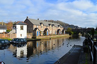
The Monmouthshire and Brecon Canal is a small network of canals in South Wales. For most of its currently (2018) navigable 35-mile (56 km) length it runs through the Brecon Beacons National Park, and its present rural character and tranquillity belies its original purpose as an industrial corridor for coal and iron, which were brought to the canal by a network of tramways and/or railroads, many of which were built and owned by the canal company.

<span class="mw-page-title-main">Ebbw Valley Railway</span> Commuter railway line in Cardiff, Wales

The Ebbw Valley Railway is a branch line of the South Wales Main Line in South Wales. Transport for Wales Rail provides an hourly passenger service each way between Ebbw Vale Town and Cardiff Central, and an hourly service each way between Ebbw Vale Town and Newport.

<span class="mw-page-title-main">Fourteen Locks</span> Series of locks in Newport, Wales

Fourteen Locks is a series of locks, also known as the Cefn Flight, on the Crumlin arm of the Monmouthshire Canal at Rogerstone in Newport, South Wales. The flight of locks was completed in 1799 and raises the water level 160 ft in just 800 yd. This is one of the steepest rises for a major run in the UK which, combined with the sheer number of locks, makes it one of the most significant in the country. The run of locks includes a series of embanked ponds, pounds, sluices and weirs to control the water supply, with no set of gates shared between individual locks. It therefore comprises a flight of locks rather than a lock staircase.

<span class="mw-page-title-main">Swansea Canal</span>

The Swansea Canal was a canal constructed by the Swansea Canal Navigation Company between 1794 and 1798, running for 16.5 miles (26.6 km) from Swansea to Hen Neuadd, Abercraf in South Wales. It was steeply graded, and 36 locks were needed to enable it to rise 373 feet (114 m) over its length. The main cargos were coal, iron and steel, and the enterprise was profitable.

High Cross is a suburb of the city of Newport, South Wales, and forms part of the community (parish) of Rogerstone.

<span class="mw-page-title-main">Llangynidr</span> Village and community in Powys, Wales

Llangynidr is a village, community and electoral ward in Powys, Wales, about 4 miles (6.4 km) west of Crickhowell and 9 miles (14.5 km) south-east of Brecon. The River Usk flows through the village as does the Monmouthshire and Brecon Canal. It is in the historic county of Brecknockshire.

Newport Docks is the collective name for a group of docks in the city of Newport, south-east Wales.

<span class="mw-page-title-main">Bosley Lock Flight</span>

Bosley Lock Flight is a flight of twelve canal locks, situated on the Macclesfield Canal at Bosley, near Macclesfield, Cheshire, England. The locks are substantially built with stone blocks, and unusually for narrow locks have mitre gates at both ends. They were each built with a side pond, which enabled some of the water to be re-used during a filling and emptying cycle. The side ponds have been disused for many years, but there are plans to reinstate one of them for demonstration purposes.

The Monmouthshire Railway and Canal Company was a canal and railway company that operated a canal and a network of railways in the Western Valley and Eastern Valley of Newport, Monmouthshire. It started as the Monmouthshire Canal Navigation and opened canals from Newport to Pontypool and to Crumlin from 1796. Numerous tramroads connected nearby pits and ironworks with the canal.

The Sirhowy Tramroad was a plateway built to convey the products of ironworks at Tredegar to Newport, South Wales. It opened in 1805 between Tredegar and Nine Mile Point, a location west of Risca, from where the Monmouthshire Canal Company operated a tramroad to Newport. The Sirhowy Tramroad was operated at first by horse traction, but early locomotives were used, and a passenger service was operated.

<span class="mw-page-title-main">Crosskeys</span> Human settlement in Wales

Crosskeys is a village, community and an electoral ward in Caerphilly county borough in Wales.

<span class="mw-page-title-main">Penar branch line</span>

The Penar branch line and the Hall's branch line, was a standard gauge freight railway line running between Risca and the Oakdale Colliery in the South Wales coalfield. It finally closed when the colliery closed in 1989 but several sections of the trackbed, line and footbridges remain, around Crosskeys. Note that the official Network Rail Engineering Line Reference (ELR) for the Halls Road branch was HRD from Halls Road Junction to Penar Junction and from the latter to Oakdale Colliery was PEN, the Penar branch. The line west of Penar tunnel made a junction with the Vale of Neath Line (VON) at Penar Junction. In December 1967, due to rationalisation of the railway network, the Halls Rd branch was taken out of use for a period and the closed Vale of Neath line was brought back into use between Penar Jct and Bird-in-Hand West to join the former LMS Sirhowy line to Nine Mile Point via Tredegar Jct Lower and Wyllie. For that journey, a run around siding had to be established on the barren VON formation at Penar Junction for the locomotive to run around its train for forward journey to Oakdale or return journey to Newport. When the former LMS branch to the Sirhowy Valley from Nine Mile Point closed, Halls Rd section was reopened in May 1970 until closure of the Halls Rd and Penar branches following 1989.

The Risca colliery disasters were a series of catastrophic mine explosions near the Welsh town of Risca in the nineteenth century. The most serious of these were in 1860 when more than 140 died in the Black Vein colliery and in 1880 when 120 died at the New Risca colliery.

References

51°40′47″N3°08′12″W / 51.6798°N 3.1368°W / 51.6798; -3.1368