
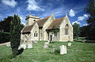
Culham Manor is a historic manor house in Culham, near Abingdon in southern Oxfordshire, England.
In 2003, the house, set in 11 acres (4.5 ha) of grounds, was for sale for GBP 2.5 million. [1]
Culham Manor is a historic manor house in Culham, near Abingdon in southern Oxfordshire, England.
In 2003, the house, set in 11 acres (4.5 ha) of grounds, was for sale for GBP 2.5 million. [1]
Circa 1420 a religious guild financed the building of Abingdon Bridge, and the 'old' bridge at Culham. The Manor House, originally a medieval barn held of the Abbots of Abingdon was also built or rebuilt around this period. [2] It was used as a rest house until the Dissolution of the Monasteries, in 1538
In 1468, a member of the Culham-based family of Marshall was a suspect in a Lancastrian plot. Robin Marshall, "late of Culham", was one of 15 suspects pardoned in July 1468 after dubious revelations by the spy John Cornelius, servant of Sir Robert Whittingham. He was probably the son of “Robert Marchal of Culneham” listed as being from Fetherstonehaugh (Fetherstanhalg) in Northumberland in 1431. After a subsequent trial, John de Vere, 12th Earl of Oxford, was executed.
Leland reported on a visit to Culham that there was previously a 'fortres or pile, lyke a castle in Andersey'. [2]
During the dissolution of Abingdon Abbey in 1545, Culham manor house was seized by Henry VIII and sold to a William Bury, a London wool trader and whose family had been Merchants of the Staple at Calais, in exchange for land in the Isle of Sheppey. [1] Bury's descendants were buried at Culham Church. His male line ended with George Bury in 1662 whose daughter Sarah (1650–80) married Sir Cecil Bishopp, 4th Baronet, of Parham Park, Sussex in 1666. [3]
The Manor House was restored by Sir Esmond Ovey between 1933 and 1948. [2]

Culham is a village and civil parish in a bend of the River Thames, 1 mile (1.6 km) south of Abingdon in Oxfordshire. The parish includes Culham Science Centre and Europa School UK. The parish is bounded by the Thames to the north, west and south, and by present and former field boundaries to the east. It is low-lying and fairly flat, rising from the Thames floodplain in the south to a north-facing escarpment in the north up to 260 feet (80 m) above sea level. The 2011 Census recorded its population as 453.

Waterstock is a village and civil parish on the River Thame about 4.5 miles (7 km) west of the market town of Thame in Oxfordshire. The parish is bounded to the north and west by the river, to the south largely by the A418 main road, and to the east largely by the minor road between Tiddington and Ickford Bridge across the Thame. On the north side of the parish, the river forms the county boundary with Buckinghamshire as well as the parish boundary with Ickford and Worminghall. Waterstock village is on a minor road north of the A418 and is surrounded by open farming land. In the village are about 50 houses and a farm along one main street.

South Stoke is a village and civil parish on an east bank of the Thames, about 1.5 miles (2.4 km) north of Goring-on-Thames in South Oxfordshire. It includes less than 1 mile (1.6 km) to its north the hamlet and manor house of Littlestoke.

Clifton Hampden is a village and civil parish on the north bank of the River Thames, just over 3 miles (5 km) east of Abingdon in Oxfordshire. Since 1932 the civil parish has included the village of Burcot, 1 mile (1.6 km) east of Clifton Hampden. The 2011 Census recorded the parish population as 662.

Montagu Bertie, 6th Earl of Abingdon was a British peer and politician. He was styled Lord Norreys from birth until acceding in 1854.
Stadhampton is a village and civil parish about 7 miles southeast of Oxford in South Oxfordshire, England. Stadhampton is close to the River Thame, a tributary of the River Thames. The village was first mentioned by name in 1146, and was in the ownership of the bishops of Lincoln, the crown, and various Oxford colleges for most of subsequent history. The village includes several buildings of historical and architectural interest, including a parish church with features dating back to the 12th-century.

Drayton St. Leonard is a village and civil parish on the River Thame in Oxfordshire, about 8 miles (13 km) southeast of Oxford.

Tetsworth is a village and civil parish about 3 miles (5 km) south of Thame in Oxfordshire. Its Parish Council is made up of six elected Councillors. The estimated population in 2018 was 752 persons. According to the Council, business included the Zioxi educational furniture plant, the Swan antiques centre and some nearby equestrian and agricultural enterprises. The village no longer had a post office or many retail operations, but retained its "church, primary school, village hall, sports on the village green, and village pub and restaurant".

Chiselhampton is a village in the civil parish of Stadhampton, on the River Thame, in the South Oxfordshire district, in the county of Oxfordshire, England. It is about 6 miles (10 km) southeast of Oxford. In 1931 the parish named Chislehampton had a population of 136. On 1 April 1932 the parish was abolished and merged with Stadhampton.

Burcot is a hamlet in the civil parish of Clifton Hampden, in the South Oxfordshire district, in the county of Oxfordshire, England. It is on the left bank of the River Thames. In 1931 the parish had a population of 187.

Andersey Island is a 273-acre (110.5 ha) area of flood-meadow and former flood-meadow south-east of Abingdon Bridge, Abingdon, Oxfordshire on the reach above Culham Lock in which parish it lies however maintaining close links with Abingdon by virtue of its current amenities. It is the second-largest island of the non-tidal course of the River Thames in England upstream of the Tideway — if disqualifying the villages of Dorney and Eton, Berkshire enclosed by the engineered Jubilee River. Andersey means Andrew's island after its chapel to St Andrew, demolished, built about 1050 CE.

James Bertie, 1st Earl of Abingdon, styled Hon. James Bertie until 1657 and known as the 5th Baron Norreys from 1657 until 1682, was an English nobleman.
Montagu Bertie, 5th Earl of Abingdon, styled Lord Norreys until 1799, was an English peer.

Chesterton is a village and civil parish on Gagle Brook, a tributary of the Langford Brook in north Oxfordshire. The village is about 1+1⁄2 miles (2.4 km) southwest of the market town of Bicester. The village has sometimes been called Great Chesterton to distinguish it from the hamlet of Little Chesterton, about 3⁄4 mile (1.2 km) to the south in the same parish. The 2011 Census recorded the parish population as 850.

Sydenham is a village and civil parish about 3 miles (5 km) southeast of Thame in Oxfordshire. To the south the parish is bounded by the ancient Lower Icknield Way, and on its other sides largely by brooks that merge as Cuttle Brook, a tributary of the River Thame. The 2011 Census recorded the parish's population as 451.

Holton is a village and civil parish in South Oxfordshire about 5.5 miles (9 km) east of Oxford. The parish is bounded to the southeast by the River Thame, to the east and north by the Thame's tributary Holton Brook, to the south by London Road and to the west by field boundaries with the parishes of Forest Hill with Shotover and Stanton St John.

Culham Bridge is a medieval bridge crossing a present backwater of the River Thames in England at Culham, Oxfordshire, near the town of Abingdon. The bridge crosses Swift Ditch which was at one time the main navigation channel of the River Thames until Abingdon Lock was built in 1790. The bridge formerly carried the A415 road from Abingdon to Dorchester, Oxfordshire, but was superseded in 1928 by a modern road bridge.

Little Milton is a village and civil parish in Oxfordshire, about 6 miles (10 km) southwest of Thame and 7 miles (11 km) southeast of Oxford. The parish is bounded to the west by the River Thame, to the south by Haseley Brook, to the north by field boundaries and to the east by an old track between Great Milton and Rofford that is now a bridleway. Little Milton village is on raised ground above the River Thame floodplain, about 250 feet (76 m) above sea level.
Robert Hucks (1699–1745) of Clifton Hampden near Abingdon, and Aldenham House, Hertfordshire, was an English brewer and Whig politician who sat in the House of Commons from 1722 to 1741.

Draycot is a hamlet on the River Thame, in the civil parish of Tiddington-with-Albury, in the South Oxfordshire district, in the county of Oxfordshire, England. It is situated approximately 4½ miles to the west of Thame. In 1881 it had a population of 17.