
Moray is one of the 32 council areas of Scotland. It lies in the north-east of the country, with a coastline on the Moray Firth, and borders the council areas of Aberdeenshire and Highland. Its council is based in Elgin, the area's largest town. The main towns are generally in the north of the area on the coastal plain. The south of the area is more sparsely populated and mountainous, including part of the Cairngorms National Park.

The Moray Firth is a roughly triangular inlet of the North Sea, north and east of Inverness, which is in the Highland council area of the north of Scotland.

Lossiemouth is a town in Moray, Scotland. Originally the port belonging to Elgin, it became an important fishing town. Although there has been over 1,000 years of settlement in the area, the present day town was formed over the past 250 years and consists of four separate communities that eventually merged into one. From 1890 to 1975, it was a police burgh as Lossiemouth and Branderburgh.

Burghead is a small town in Moray, Scotland, about 8 miles (13 km) north-west of Elgin. The town is mainly built on a peninsula that projects north-westward into the Moray Firth, surrounding it by water on three sides. People from Burghead are called Brochers.
The County of Moray, or Morayshire, called Elginshire until 1919, is a historic county in Scotland. The county town was Elgin. The historic county ceased to be used for local government purposes in 1975. Since 1996 most of the historic county's area has been included in the Moray council area. The historic county boundaries are still used for certain functions, being a registration county. There is also a Moray lieutenancy area, covering a slightly smaller area than the historic county. The historic county borders Nairnshire to the west, Inverness-shire to the south, and Banffshire to the east, and has a coast onto the Moray Firth to the north.

The Great Glen, also known as Glen Albyn or Glen More, is a glen in Scotland running for 62 miles (100 km) from Inverness on the edge of the Moray Firth, in an approximately straight line to Fort William at the head of Loch Linnhe. It follows a geological fault known as the Great Glen Fault, and bisects the Scottish Highlands into the Grampian Mountains to the southeast and the Northwest Highlands to the northwest.

Buckie is a burgh town on the Moray Firth coast of Scotland. Historically in Banffshire, Buckie was the largest town in the county until the administrative area was abolished in 1975. The town is the third largest in the Moray council area after Elgin and Forres and within the definitions of statistics published by the General Register Office for Scotland was ranked at number 75 in the list of population estimates for settlements in Scotland mid-year 2006. Buckie is virtually equidistant to Banff to the east and Elgin to the west, with both approximately 17 miles distant whilst Keith lies 12 mi (19 km) to the south by road.

Findochty is a village in Moray, Scotland, on the shores of the Moray Firth; historically it was part of Banffshire. The Gaelic name of the village was recorded by Diack using his own transcription method as fanna-guchti, which is of unclear meaning. One of the earliest references to Findochty is in 1440, when the king granted Findachtifeild to John Dufe, son of John Dufe. The lands passed from the Duffs to the Ogilvies of Findlater, and subsequently, in 1568, the Ord family acquired the manor, port, custom, and fishers' lands of Findochty, and later built the House of Findochty, known as Findochty Castle, now a ruin, which stands to the west of the village. In 1716 the Ords brought 13 men and 4 boys from Fraserburgh under contract to fish from Findochty, and for a time the harbour was busy with landings of herring and white fish. Findochty expanded as a fishing port through the 1700s and 1800s, and by 1850 was home to 140 fishing boats. But the expansion in the late 1800s of nearby Buckie provided a better harbour, and some of the fishing fleet had left Findochty by 1890. Findochty harbour is now used mostly by pleasure craft and is a good sun spot when the tide is out. A local artist, Correna Cowie, created a statue in 1959 of a seated fisherman, known as The White Mannie, who watches over the harbour.
Yellowcraig, also known as Broad Sands Beach, is a coastal area of forest, beach and grassland in East Lothian, south-east Scotland. Yellowcraig is partly within the Firth of Forth Site of Special Scientific Interest (SSSI). It is bordered to the north by the Firth of Forth, to the south by the village of Dirleton and Dirleton Castle, to the east by the North Berwick West Links golf course, and to the west by the Archerfield Estate and Links golf courses.

The Forth and Clyde canal pathway runs between the Firth of Forth and the Firth of Clyde and is a 106-kilometre-long (66 mi) footpath and cycleway that runs across Scotland, between Bowling, west of Glasgow, and Lochrin Basin in Edinburgh. The path runs on the towpaths of the Forth & Clyde and Union Canals and is entirely off-road. The path is well maintained and its surface is generally good, although there are some stretches particularly between Falkirk and the outskirts of Edinburgh where wet weather leads to muddy conditions unsuitable for road intended bicycles. It is well used by walkers and cyclists, and designated as one of Scotland's Great Trails by NatureScot. It also forms part of the National Cycle Network, being designated as Route 754. Sustrans advises that the path is best followed from the Clyde to the Forth because the prevailing wind is from the south west. Much of the path is also suitable for experienced horseriders, although in some places low bridges, narrow aqueducts and gates may restrict access for horses.

Hopeman is a seaside village in Moray, Scotland, it is situated on the coast of the Moray Firth, founded in 1805 to house and re-employ people displaced during the Highland clearances. According to the 2011 census, Hopeman has a population of 1,724 and approximately 701 households.

Portgordon, or sometimes Port Gordon, is a village in Moray, Scotland, 2 km south-west of Buckie. It was established in 1797 by Alexander Gordon, 4th Duke of Gordon as a fishing village. It had a population of 844 at the time of the 2011 census. The Portgordon Community Harbour Group was trying to regenerate the harbour and open a marina.

The A832 is a road in the Scottish Highlands, linking Cromarty, on the east coast, to Gairloch on the west coast, and beyond Gairloch to Braemore Junction. It is 126 miles (203 km) long and runs entirely in the former county of Ross and Cromarty. The road forms part of the Wester Ross Coastal Trail.
Lossiemouth High School is a secondary school in the coastal town of Lossiemouth, Moray, Scotland.
The Scottish Coastal Way is a proposed national long-distance trail that goes around the coastline of mainland Scotland. The idea was first proposed by walkers, and in November 2009 Scottish Natural Heritage (SNH) hosted a conference on the subject. In 2010 SNH estimated that around 2,700 km of coastal paths and routes were existence, compared to a total coastline length of 10,192 km. The existing coastal paths were predominantly in the more populous parts of the country, and few coastal paths exist in more remote areas such as Highlands and Islands. It was recognised that a coastal route, along the lines of the Wales Coast Path, would have many positives, but that development of a fully waymarked route would conflict with conservation aims such as the preservation of the "wild land" qualities of much of the Scottish coast.

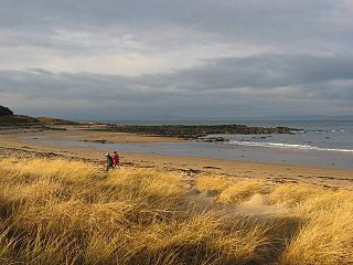
The Moray Coastal Trail is a long-distance path in North-East Scotland that runs along the coastline of the Moray council area. The route, which is 72 km (45 mi) long, runs between Forres and Cullen. It is designated as one of Scotland's Great Trails by NatureScot, and connects with two further Great Trails: the Speyside Way at Spey Bay, and the Dava Way at Forres. The Moray Coast Trail can be combined with sections of these two routes to form a 153 km (95 mi) circular route known as the Moray Way, and also forms part of the North Sea Trail. The trail is primarily intended for walkers, but many sections are also suitable for cycling and horseriding. An alternative route for cycling, the Moray Coast Ride, shares some sections of path with the Moray Coast Trail, and forms part of the National Cycle Network's Route 1. About 23,000 people use the path every year, of whom about 1,000 complete the entire route.

Buckpool railway station was a railway station in Buckpool near Buckie in Moray. The railway station was opened by the Great North of Scotland Railway (GNoSR) on its Moray Firth coast line in 1886, served by Aberdeen to Elgin trains. The village and station were originally named Nether Buckie station and the station was renamed 'Buckpool' on 1 January 1887, closing to regular passenger traffic on 7 March 1960, several years before the closure of the line itself in 1968.

Burghead was a railway station serving Burghead in the Scottish district of Moray. Initially the station was the terminus of the branch line from Alves but later a through station, at a new location, as the line was extended to Hopeman.
Cummingston railway station stood on the Burghead and Hopeman Branch of the Highland Railway and once served the small village of Cummingston, formerly Cummingstown, in the Scottish district of Moray.

