Cunningar

Last updated

Cunningar
New South Wales
Australia New South Wales location map blank.svg
Red pog.svg
Cunningar
Coordinates 34°33′35.8″S148°24′59.4″E / 34.559944°S 148.416500°E / -34.559944; 148.416500
Population163 (SAL 2021) [1]
Postcode(s) 2587
LGA(s) Hilltops Council
County Harden
State electorate(s) Cootamundra
Federal division(s) Hume

Cunningar is a locality in the Hilltops Council local government area, within the South West Slopes region of New South Wales, Australia. It is located immediately to the east of the town of Harden. There is a parish of the County of Harden of the same name, which comprises a part of the area of the locality.

The area now known as Cunningar lies on the traditional lands of Ngunnawal people, close to the eastern edge of the traditional lands of Wiradjuri people. [2]

Following colonial settlement, the area became used predominantly for agriculture and grazing. When the official map of Thomas Mitchell was made in 1834, there was already one settler house shown at what was then called Cunningham's Plains. [3] Cunningham's Plains was the name of an immense rural estate of around 60,000 acres, which was not sub-divided into smaller properties until the early 20th century. [4] Cunningar remains a rural locality today. As the area lay outside the Nineteen Counties, in which the colonial government permitted colonial settlement, the first settlers of the area, before 1834, were undoubtedly squatters, who had moved onto Aboriginal land and taken it over.

A village of Cunningar was proclaimed in 1857 and town lots were put up for sale in the same year. [5] [6] Around that time, it was uncertain whether Cunningar or Murrumburrah would become the larger settlement in the area, but the discovery of gold at Demondrille, near Murrumburrah, caused that town to prosper. [3]

Two of the streets of the village still exist today, as Allen and Allman Streets. However, the main part of the village was to have been north-east of the main road and railway line, with the two existing streets being just one corner of a larger town plan. [7] [8] In 1881, the site was selected for a town of Cunningar, which was proclaimed in 1885. Its boundaries were proclaimed in 1891. [9] [10]

There was quartz reef mining for gold and silver, in the mid-1880s and 1890s. carried out by the 'Cunningar Company', It seems that was at a mine, in the south of the locality in the area known as MacMahon's Reef, which originally dated from the 1870s. An unusual feature of this operation was that the quartz was smelted in a 'water-jacket' (blast) furnace using coke as fuel, rather than crushing the quartz, to extract the gold and silver. [11] [12] [13] [14] It was probably the presence of the smelter that led to the plan for a larger town.[ original research? ]

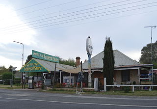
The development of a large centre so close to Murrumburrah—and later Murrumburrah's twin town, Harden, which was even closer—was unlikely, and only a small settlement ever developed at Cunningar. In 1937, it had a 'cottage post office', church hall and school. [3] The Anglican Church Hall (St Barnabas) was built and opened in 1922. It functioned both as a church and public hall, with the sanctuary screened off when not in use for worship. It hosted public functions such as dances and socials, as late as the early 1950s. [15] [16] Cunningar had a public school from 1870 to 1960. [17] It had a railway station, operating from 1877 to 1975, that no longer exists. [18] Its post office closed in 1967. [19] However, the larger town plan of Cunningar still existed, on paper only, into the 1970s. [7]

Cunningar lies on the Main Southern railway line, and it has a grain siding and storage facility. In a good season, about 100,000 tonnes of grain pass through the siding. Graincorp upgraded the grain facility at the rail siding in 2017, using funds that were raised in part by local grain growers, saving around $8 to $10 per tonne in grain handling costs. [20] [21] [22]

In 2016, the population was 145, [23] which had increased to 163 at the 2021 census. [24]

Related Research Articles

<span class="mw-page-title-main">Harden, New South Wales</span> Town in New South Wales, Australia

Harden–Murrumburrah is a township and community in the Hilltops Region and is located in the South West Slopes of New South Wales in Australia. Harden is adjacent to both the Canberra region of the Australian Capital Territory and the Riverina Region in the southwest area of NSW. The town is a twin town between Harden and Murrumburrah.

<span class="mw-page-title-main">Mongarlowe, New South Wales</span> Town in New South Wales, Australia

Mongarlowe is a village in the Southern Tablelands of New South Wales, Australia in Queanbeyan-Palerang Regional Council. In former times, it was also known, in various contexts, as Little River, Monga, and Sergeants Point. The name, Mongarlowe, also applies to the surrounding area, for postal and statistical purposes.

<span class="mw-page-title-main">Wee Jasper, New South Wales</span> Town in New South Wales, Australia

Wee Jasper is a hamlet in the Yass Valley Shire in New South Wales, Australia, about 90 km north-west of Canberra and 60 km south-west of Yass. It is in the Goodradigbee valley at the western foot of the Brindabella Ranges, near Burrinjuck Dam. At the 2021 census, Wee Jasper and the surrounding area had a population of 127.

<span class="mw-page-title-main">Harden Shire</span> Former local government area in New South Wales, Australia

Harden Shire was a local government area in the South West Slopes region of New South Wales, Australia. The Shire included the twin towns of Harden and Murrumburrah and the small towns of Galong, Jugiong, Wombat and Kingsvale.

<span class="mw-page-title-main">Murrumburrah</span> Town in New South Wales, Australia

Murrumburrah is a township in New South Wales, Australia, part of a twin town with Harden. The town is in Hilltops Council local government area in the South West Slopes area of NSW. It is on the Burley Griffin Way, the major link from the Riverina to the Hume Highway near Yass, and ultimately Sydney, Canberra and the coast.

<span class="mw-page-title-main">Harden railway station</span> Railway station in New South Wales, Australia

Harden railway station is a heritage-listed railway station located on the Main South line in New South Wales, Australia. It serves the town of Harden. It was added to the New South Wales State Heritage Register on 2 April 1999.

Burraga is located in the Central Tablelands of New South Wales, 47 kilometres south west of Oberon and about 67 kilometres (42 mi) south of Bathurst. It is within Oberon Shire. At the 2016 census, Burraga had a population of 91.

<span class="mw-page-title-main">Currawang</span> Cadastral in New South Wales, Australia

Currawang is a rural locality, located to the north of Lake George. in New South Wales, Australia. It lies on the intersection between three councils, with the majority straddling the boundary between the Queanbeyan–Palerang Regional Council and Goulburn-Mulwaree Council and a small portion of the locality in the Upper Lachlan Shire. It shares its name with the Currawang Parish of Argyle County, in which it is located. This was formerly known as the parish of Currowang. Both names derive from an Aboriginal word for the spearwood tree.

<span class="mw-page-title-main">Hoskinstown</span> Town in New South Wales, Australia

Hoskinstown is a locality in Queanbeyan-Palerang Regional Council, New South Wales, Australia. The locality, and what remains of the cluster of settlement of the same name, is 38 km southeast of Canberra the Capital city of Australia, and 299 km southwest of Sydney. At the 2021 census, it had a population of 191.

Trewilga is a bounded rural locality in Parkes Shire, within the Central West region of New South Wales, Australia. There was once a village and railway station of the same name.

<i>Murrumburrah Signal and County of Harden Advocate</i>

The Murrumburrah Signal and County of Harden Advocate, also known as the Murrumburrah Signal, andThe Signal, Murrumburrah-Harden, was an English language newspaper published from 1881 to 1947 in Murrumburrah, New South Wales, Australia.

<span class="mw-page-title-main">Demondrille Shire</span> Former local government area in New South Wales, Australia

Demondrille Shire was a local government area in the South West Slopes region of New South Wales, Australia.

<span class="mw-page-title-main">Colinton, New South Wales</span> Town in New South Wales, Australia

Colinton is a locality in the Snowy Monaro Region, New South Wales, Australia. At the 2016 census, it had a population of 127. There was once a village and railway station of the same name.

<span class="mw-page-title-main">Merricumbene</span> Town in New South Wales, Australia

Merricumbene is a locality in the Eurobodalla Shire, New South Wales, Australia. It is located about 43 km south of Braidwood and 40 km northwest of Moruya in the valley of the Deua River. At the 2016 census, it had a population of 19.

<span class="mw-page-title-main">Cumbamurra, New South Wales</span> Civil parish in New South Wales, Australia

Cumbamurra, New South Wales is a civil parish of Harden County, New South Wales.

<span class="mw-page-title-main">Wattle Flat, New South Wales</span> Town in New South Wales, Australia

Wattle Flat is a locality in the Bathurst Region of New South Wales, Australia. It had a population of 257 people as of the 2016 census. There is a small village of the same name, near the confluence of Big Oaky Creek and its tributary Solitary Creek.

<span class="mw-page-title-main">Gilgunnia</span> Locality in New South Wales, Australia

Gilgunnia is a locality and ghost town in the Orana region of New South Wales, Australia, within the Parish of South Peak in Blaxland County and Cobar Shire. It was once a settlement associated with gold mining, but in 2016 its population was zero. The nearest settlements are Mount Hope and Nymagee.

Caloola is a locality in the Central West region of New South Wales. There once was a small village of the same name but it is a ghost town today. At the 2016 census, the locality had a population of 88.

Dalmorton is a locality in the Northern Rivers region of New South Wales, Australia. There once was a village of the same name, which was associated with gold mining. Much of the area of the locality is now reserved as National Parks or State Forests. At the 2016 census, the population of Dalmorton was four.

<span class="mw-page-title-main">North Yalgogrin</span> Town in New South Wales, Australia

North Yalgogrin is a locality in the Bland Shire local government area of New South Wales. There once was a village there, named Yalgogrin, but better known as Yalgogrin North.

References

  1. Australian Bureau of Statistics (28 June 2022). "Cunningar (Suburb and Locality)". Australian Census 2021 QuickStats. Retrieved 28 June 2022.  OOjs UI icon edit-ltr-progressive.svg
  2. Studies, Australian Institute of Aboriginal and Torres Strait Islander (10 January 2021). "Map of Indigenous Australia". aiatsis.gov.au. Retrieved 30 October 2021.
  3. 1 2 3 "History of the Settlement and Growth of the Murrumburrah District". Murrumburrah Signal and County of Harden Advocate. 18 November 1937. Retrieved 2 November 2021.
  4. "CUNNINGHAM PLAINS". Murrumburrah Signal and County of Harden Advocate. 12 July 1907. Retrieved 2 November 2021.
  5. "New South Wales Government Gazette". Trove. 25 November 1857. p. 2234. Retrieved 23 May 2022.
  6. "Trove". trove.nla.gov.au. Retrieved 30 October 2021.
  7. 1 2 "Town of Cunningar and adjoining lands [cartographic material] : Parish - Cumbamurra, County - Harden, Land District - Young, Shire - Demondrille : within Division - Eastern N.S.W., Pastures Protection District - Young". Trove. Retrieved 30 October 2021.
  8. "Parish of Cunningar, County of Harden [cartographic material] : Land Districts of Boorowa & Young". Trove. Retrieved 31 October 2021.
  9. "SITE FOR TOWN AT CUNNINGAR". New South Wales Government Gazette. 28 February 1881. Retrieved 31 October 2021.
  10. "THE LAND ACT". Daily Telegraph. 23 March 1885. Retrieved 31 October 2021.
  11. "THE CUNNINGAR SMELTING PLANT". Ballarat Star. 10 December 1885. Retrieved 30 October 2021.
  12. "OPENING OF THE CUNNINGAR GOLD REEFING WORKS". Goulburn Herald. 10 December 1885. Retrieved 30 October 2021.
  13. "CUNNINGAR COMPANY, MURRUM-BURRAH, N.S.W." Ballarat Star. 2 December 1885. Retrieved 30 October 2021.
  14. "MINING INTELLIGENCE". Sydney Morning Herald. 19 November 1885. Retrieved 31 October 2021.
  15. "CHURCH HALL AT CUNNINGAR". Young Witness. 4 May 1922. Retrieved 31 October 2021.
  16. "OUR NEIGHBORS". Cootamundra Herald. 4 April 1950. Retrieved 31 October 2021.
  17. "Cunningar". nswgovschoolhistory.cese.nsw.gov.au. Archived from the original on 30 October 2021. Retrieved 30 October 2021.
  18. "Cunningar Station". nswrail.net. Retrieved 30 October 2021.
  19. "View Post Office Details - Cunningar". www.phoenixauctions.com.au. Retrieved 1 February 2022.
  20. Thistleton, John. "Meet the grain growers who refused to let Cunningar die". The RiotACT. Retrieved 30 October 2021.
  21. "GrainCorp completes Cunningar grain terminal upgrade". www.world-grain.com. Retrieved 2 November 2021.
  22. "Upgraded Cunningar site boosts GrainCorp efficiency into Port Kembla". Grain Central. 19 December 2017. Retrieved 2 November 2021.
  23. Australian Bureau of Statistics (27 June 2017). "Cunningar". 2016 Census QuickStats. Retrieved 23 May 2022. OOjs UI icon edit-ltr-progressive.svg
  24. "2021 Cunningar, Census All persons QuickStats". Australian Bureau of Statistics. Retrieved 15 August 2022.