Jones County is a county located in the U.S. state of Georgia. As of the 2010 census, the population was 28,669. The county seat is Gray. The county was created on December 10, 1807 and named after U.S. Representative James Jones.

The Owl Creek Mountains are a subrange of the Rocky Mountains in central Wyoming in the United States, running east to west to form a bridge between the Absaroka Range to the northwest and the Bridger Mountains to the east. The range forms the boundary between the Bighorn Basin to the north and the Shoshone Basin to the south. The Wind River passes through the gap between the range and the Bridger Mountains to the east, and becomes the Bighorn River on the north side of the mountains. The high point of the range is 9,665 feet (2,946 m). The range is entirely within the Wind River Indian Reservation.

The Bridger Mountains are a short subrange of the Rocky Mountains, approximately 40 miles (64 km) long, in central Wyoming in the United States. The range forms a bridge between the Owl Creek Mountains to the west and the southern end of the Bighorn Mountains to the east. The Wind River passes through the gap between the range and the Owl Creek Mountains. Bridger Creek passes through the gap between the range and the Bighorns. The highest point in the range is Copper Mountain at 8,300 feet (2,500 m).

The Clackamas River is an approximately 83-mile (134 km) tributary of the Willamette River in northwestern Oregon, in the United States. Draining an area of about 940 square miles (2,435 km2), the Clackamas flows through mostly forested and rugged mountainous terrain in its upper reaches, and passes agricultural and urban areas in its lower third. The river rises in eastern Marion County, about 55 miles (89 km) east-southeast of Salem. The headwaters are on the slopes of Olallie Butte in the Mount Hood National Forest, about 10 miles (16 km) north of Mount Jefferson, at an elevation of 4,909 feet (1,496 m) in the Cascade Range. The Clackamas flows briefly north and then flows northwest through the mountains, passing through North Fork Reservoir and Estacada. It then emerges from the mountains southeast of Portland. It joins the Willamette near Oregon City and forms the boundary between Oregon City and Gladstone.

The Christina River is a tributary of the Delaware River, approximately 35 miles (56 km) long, in northern Delaware in the United States, also flowing through small areas of southeastern Pennsylvania and northeastern Maryland. Near its mouth the river flows past downtown Wilmington, Delaware, forming the city's harbor for traffic on the Delaware River. The Port of Wilmington, opened in 1923 at the river's mouth, handles international cargo and trade.

The Humboldt River runs through northern Nevada in the western United States. At approximately 290 miles (470 km) long it is the third longest river in the Great Basin, after the Bear and Sevier Rivers. It has no outlet to the ocean, but instead empties into the Humboldt Sink. It is the fifth largest river in the United States, in terms of discharge, that does not ultimately reach the ocean, while it is the largest in terms of area drained. Through its tributaries the river drains most of sparsely populated northern Nevada, traversing the state roughly east to west, and passing through repeated gaps in the north-south running mountain ranges. It furnishes the only natural transportation artery across the Great Basin and has provided a route for historic westward migrations and subsequent railroads and highways. The river is named for the German naturalist Alexander von Humboldt.

Middle Park is a high basin in the Rocky Mountains of north-central Colorado in the United States. It is located in Grand County, on the southwest slope of Rocky Mountain National Park, approximately 50 miles (80 km) west of Boulder.

The Kaweah River is a river draining the southern Sierra Nevada in Tulare County, California in the United States. Fed primarily by high elevation snowmelt along the Great Western Divide, the Kaweah begins as four forks in Sequoia National Park, where the watershed is noted for its alpine scenery and its dense concentrations of giant sequoias, the largest trees on Earth. It then flows in a southwest direction to Lake Kaweah – the only major reservoir on the river – and into the San Joaquin Valley, where it diverges into multiple channels across an alluvial plain around Visalia. With its Middle Fork headwaters starting at almost 13,000 feet (4,000 m) above sea level, the river has a vertical drop of nearly two and a half miles (4.0 km) on its short run to the San Joaquin Valley, making it one of the steepest river drainages in the United States. Although the main stem of the Kaweah is only 33.6 miles (54.1 km) long, its total length including headwaters and lower branches is nearly 100 miles (160 km).
The White Pine Range is a group of mountains in southern White Pine County, in eastern Nevada. The range runs for approximately 51 miles (82 km) from Beck Pass in the north to Currant Pass in the south. To the west of the range are the Duckwater (Shoshone) tribal lands and the northern arm of large Railroad Valley. To the east are Jakes Valley and the northern part of the long White River Valley. To the south are the Horse and Grant Ranges.
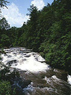
The Soque River and its watershed are located entirely within the county boundaries of Habersham County in northeast Georgia. The Soque is a tributary of the Chattahoochee River. Portions of the river run along State Route 197.

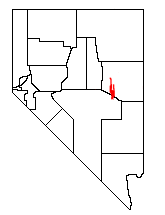
The Currant Mountain Wilderness is a 47,357-acre (19,165 ha) wilderness area centered on Currant Mountain in the White Pine Range of Nye County and White Pine County, in the eastern section of the state of Nevada in the western United States.

The Klamath Basin is the region in the U.S. states of Oregon and California drained by the Klamath River. It contains most of Klamath County and parts of Lake and Jackson counties in Oregon, and parts of Del Norte, Humboldt, Modoc, Siskiyou, and Trinity counties in California. The 15,751-square-mile (40,790 km2) drainage basin is 35% in Oregon and 65% in California. In Oregon, the watershed typically lies east of the Cascade Range, while California contains most of the river's segment that passes through the mountains. In the Oregon-far northern California segment of the river, the watershed is semi-desert at lower elevations and dry alpine in the upper elevations. In the western part of the basin, in California, however, the climate is more of temperate rainforest, and the Trinity River watershed consists of a more typical alpine climate.

The Uinta Basin is a physiographic section of the larger Colorado Plateaus province, which in turn is part of the larger Intermontane Plateaus physiographic division. It is also a geologic structural basin in eastern Utah, east of the Wasatch Mountains and south of the Uinta Mountains. The Uinta Basin is fed by creeks and rivers flowing south from the Uinta Mountains. Many of the principal rivers flow into the Duchesne River which feeds the Green River—a tributary of the Colorado River. The Uinta Mountains forms the northern border of the Uinta Basin. They contain the highest point in Utah, Kings Peak, with a summit 13,528 feet above sea level. The climate of the Uinta Basin is semi-arid, with occasionally severe winter cold.

Park Valley is an unincorporated community in north-central Box Elder County, Utah, United States.

Salmon Falls Creek is a tributary of the Snake River, flowing from northern Nevada into Idaho in the United States. Formed in high mountains at the northern edge of the Great Basin, Salmon Falls Creek flows northwards 121 miles (195 km), draining an arid and mountainous basin of 2,103 square miles (5,450 km2). The Salmon Falls Creek valley served as a trade route between the Native American groups of the Snake River Plain and Great Basin. Today, most of its water is used for irrigation.

Kitchen Creek is a tributary of Huntington Creek in Luzerne County, Pennsylvania, in the United States. It is approximately 10.6 miles (17.1 km) long and flows through Fairmount Township and Huntington Township. The watershed of the creek has an area of 20.10 square miles (52.1 km2). The creek is designated as a high-quality coldwater fishery.

The Big Jacks Creek Wilderness is located on the high basalt plateaus of Owyhee County in southwestern Idaho in the western United States. Little Jacks Creek Wilderness is on its northwest border. About 35 miles (56 km) of Big Jacks Creek is classified as a wild river.
The Juab Valley is a 40-mile (64 km) long valley located on the eastern edge of Juab County, Utah, United States.
Currant Creek may refer to:

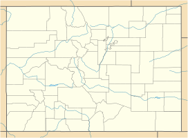
Currant Creek is a stream in eastern Juab County and southern Utah County in northern Utah, United States.