
Barrow-in-Furness is a town in Cumbria, North-West England. Historically part of Lancashire, it was incorporated as a municipal borough in 1867 and merged with Dalton-in-Furness Urban District in 1974 to form the Borough of Barrow-in-Furness. At the tip of the Furness peninsula, close to the Lake District, it is bordered by Morecambe Bay, the Duddon Estuary and the Irish Sea. In 2011, Barrow's population was 57,000, making it the second largest urban area in Cumbria after Carlisle. Natives of Barrow, as well as the local dialect, are known as Barrovian.

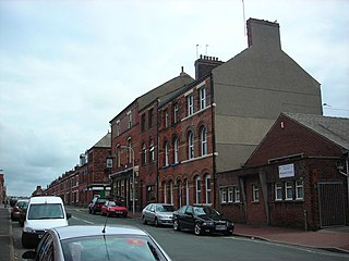
Portland Walk is a shopping centre in Barrow-in-Furness, Cumbria, England. Constructed in 1998 on the site of the former Forshaw Street, it was designed as a modern extension to Dalton Road; Barrow's principal shopping district. Barrow Indoor Market is also located adjacent to the southern entrance of the centre. Portland Walk has a total retail floor area of around 200,000 sq ft (19,000 m2) and contains over 30 stores and services. The complex is entirely open-air, however, there has been unsuccessful proposals to cover it with a roof. A 500-space multi-storey car park provides direct access to the centre.
Hindpool is an area and electoral ward of Barrow-in-Furness, Cumbria, England. It is bordered by Barrow Island, Central Barrow, Ormsgill, Parkside and the Walney Channel, the local population stood at 5,851 in 2011. The ward covers the entire western half of the town centre and includes Barrow's main shopping district. Other local landmarks include the Furness College Channelside campus, the Dock Museum and the Main Public Library. Hindpool is also home to two stadia - Barrow Raiders' Craven Park and Barrow A.F.C.'s Holker Street.

Abbey Road is the principal north to south arterial road through Barrow-in-Furness, Cumbria, England.

The Hindpool Retail Parks are a set of four conjoined retail parks in the Hindpool area of Barrow-in-Furness, England, United Kingdom. Some thirty stores and leisure facilities contain a total of 43,000 m2 (460,000 sq ft) of retail space. The four retail parks are Cornerhouse Retail Park, Cornmill Crossing, Hindpool Retail Park and Hollywood Park. The largest and only other retail park in Barrow is Walney Road Retail Park - Pound Stretcher, Argos Extra, Asda, Home Bargains, Matalan and Stollers.
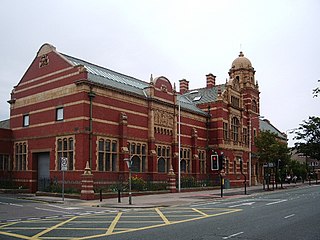
The Nan Tait Centre is a Grade II listed building located at Abbey Road in the Hindpool area of Barrow-in-Furness, Cumbria, England.

The Furness Abbey Hotel, now a public house named The Abbey Tavern, stands in Abbey Approach, Barrow-in-Furness, Cumbria, England, to the north of the remains of Furness Abbey. The current structure is recorded in the National Heritage List for England as a designated Grade II listed building.

The John Whinnerah Institute is a Grade II listed Art Deco building and former educational establishment located on Abbey Road in Barrow-in-Furness, England. Having been constructed between 1937 and 1938 on the site of the demolished Jute Works it is the newest listed structure in the town, despite this it was drastically altered in 2004 when the entire interior was demolished to accommodate new retail units leaving only the Abbey Road and Hindpool Road facades.
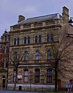
The National Westminster Bank building in Barrow-in-Furness, Cumbria, England is located at the intersection of Abbey Road and Duke Street. It was designed by Paley and Austin architects and built between 1873-74 and has been designated a Grade II listed building by English Heritage. Built for the Lancaster branch of the National Westminster Bank it was a major component of the Ramsden Square scheme, one of the planned town's two main squares and focal points. It is one of three former 'Nat West' properties with listed building status in the Borough and currently houses a carpet shop in the lower floors.

The Barrow Jute Works was a jute and flax mill located in Barrow-in-Furness, Lancashire, England during the late 19th and early 20th centuries. The mill was built for the Barrow and Calcutta Jute Company which was founded by James Ramsden in 1870 in an attempt to diversify Barrow's economy which was heavily focused on iron and steel production. The Jute Works itself was designed by architects Paley and Austin and occupied over 12-acres with a 580 feet (177 m) facade on Hindpool Road and 360 feet (110 m) along Abbey Road. The mill was served by its own railway station on a branch of the Furness Railway which connected it to the town's docks, steelworks and cornmill.

The Custom House, Lancaster is a grade II* listed building located on St Georges Quay, Lancaster, Lancashire, England. The architect was Richard Gillow of the Gillow furniture making family. Designed in 1764 for the Port Commissioners, it was used for its original purpose until 1882 when the Customs were transferred to Barrow-in-Furness.

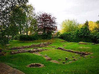
Abbot's Wood was a large country house and estate located to the north-northeast of Barrow-in-Furness, Cumbria, England. It was sited on elevated ground to the northeast of Furness Abbey. The house was surrounded by extensive grounds with footpaths providing fine views.
St. George's Square, in Barrow-in-Furness, Cumbria, England is a public space that acted as the centre of the town during the late 19th century. The square now lies in the southernmost fringes of the Central ward close to the Port of Barrow.

Ramsden Square is a square located at the intersection of Abbey Road and Duke Street in Barrow-in-Furness, Cumbria, England. It marks the boundary of the Central and Hindpool wards and now acts as a major roundabout. Ramsden Square was first laid out in the 1840s to act as a focal point of Sir James Ramsden's master plan for the new town of Barrow, separating its burgeoning industries and commercial core. The centerpiece of the square is a statue of Ramsden himself while it is framed by a number of historic buildings including Barrow Central Library, the National Westminster Bank Building and formerly the Barrow Jute Works.

Barrow-in-Furness Strand railway station was the first permanent railway terminus to be built in Barrow-in-Furness, England. Located on the Strand at St. George's Square close to the town's docks its functioning life was short, however the building itself continued to be used as the headquarters of the Furness Railway for a number of years. The station opened in 1863 having replaced a wooden structure which was erected in 1846 at adjacent Rabbit Hill. The station at St. George's square ceased commercial operations in 1882 upon the completion of a new loop line and much larger station at Abbey Road. Barrow-in-Furness Central railway station, later simply renamed Barrow-in-Furness railway station has been the town's primary station ever since.
Schneider Square is a square located at the intersection of Duke Street, Dalton Road, Michaelson Road, Burlington Street and Fisher's Yard in Barrow-in-Furness, Cumbria, England. Schneider Square has changed little since its construction in the mid-19th century and now lies within a conservation area. Named after Henry Schneider who played a major role in the development of Barrow, there is a statue commemorating the industrialist in the centre of the square. Located on, or immediately adjacent to Schneider Square are Barrow Town Hall, Craven House, former Barrow Higher Grade School, Hotel Majestic, Burlington House and Duke Street Surgery.

Piel railway station was the terminus of the Furness Railway's Piel Branch in Barrow-in-Furness, England that operated between 1846 and 1936. Located on Roa Island it was built to serve the passenger steamers at Piel Pier. The Roa Island causeway was specifically constructed for the railway, in turn making the island part of the British mainland. The station and the Piel Branch line have both been demolished, however the Roa Island Hotel which was built adjoining the station survives to this day as a Grade II listed building.
This is a list of scheduled monuments in the English county of Lancashire.
