Arcola Airport is located adjacent to Arcola, Saskatchewan, Canada. Burton Ag Air Ltd. operates a fixed base at the airport.
Camsell Portage Airport is located adjacent to Camsell Portage, Saskatchewan, Canada.
Canora Airport is located adjacent to Canora, Saskatchewan, Canada.
Cluff Lake Airport(IATA: XCL, TC LID: CJS3) is a decommissioned airstrip located near Cluff Lake mine in north-western Saskatchewan, Canada at the northern terminus of Highway 955.
Cudworth Municipal Airport is located adjacent to Cudworth, Saskatchewan, Canada.
Davin Lake Airport, formerly TC LID: CKW6, was located adjacent to Davin Lake Lodge, a fly-in fishing lodge in northern Saskatchewan, Canada.
Dinsmore Aerodrome is located adjacent to Dinsmore, Saskatchewan, Canada.
Estevan (South) Airport TC LID: CKK4 was a registered aerodrome located 5 nautical miles south of Estevan, Saskatchewan, Canada.
Key Lake Airport is a regional airport near the Key Lake mine in Saskatchewan, Canada.
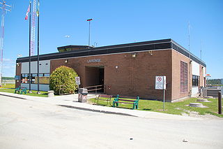
La Ronge Airport is located 2 nautical miles north-east of La Ronge, Saskatchewan, Canada.
Lumsden (Metz) Airport, formerly TC LID: CKR5\, was located 6 NM north-west of Lumsden, Saskatchewan, Canada.
Paradise Hill Airport(TC LID: CJE6) was located adjacent to Paradise Hill, Saskatchewan, Canada.
Points North Landing Airport is a regional airport adjacent to Points North Landing in Saskatchewan, Canada.
White City (Radomsky) Airport, formerly TC LID: CWC1, is located 1.5 nautical miles east of White City, Saskatchewan, Canada.
Yorkton Municipal Airport is located 2.8 nautical miles north of Yorkton, Saskatchewan, Canada.
Highway 954 is a provincial highway in the Canadian province of Saskatchewan. It runs from Highway 26 on the north side of Goodsoil to a dead end at Northern Cross Resort on Lac des Îles within Meadow Lake Provincial Park. At the eastern end of the highway is the Goodsoil Airport. It is about 12.9 kilometres (8.0 mi) long.

The Rural Municipality of Arborfield No. 456 is a rural municipality (RM) in the Canadian province of Saskatchewan within Census Division No. 14 and SARM Division No. 4.
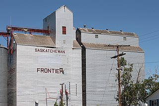
Frontier is a village in the Canadian province of Saskatchewan within the Rural Municipality of Frontier No. 19 and Census Division No. 4. Frontier is on Highway 18 and is served by the Frontier Airport located (3.7 km) south of the village.

The Rural Municipality of Cut Knife No. 439 is a rural municipality (RM) in the Canadian province of Saskatchewan within Census Division No. 13 and SARM Division No. 6.

