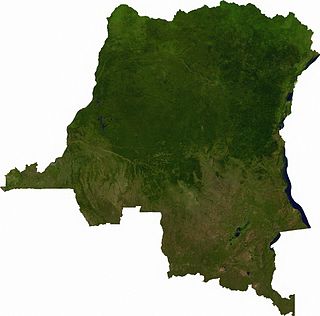
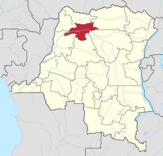
Location
Cuvette Centrale Province covered the area of the present provinces of Équateur and Tshuapa in the northwest of the Democratic Republic of the Congo. It is named after the Cuvette Centrale (Central Basin), a geological basin covering an area of around 800,000 square kilometres (310,000 sq mi) to the north of Kinshasa. This is a region of swamps and dense tropical forest, with few roads and no railways. Under the law of 14 August 1962 Cuvette Centrale Province comprised the territories of Basankusu, Bolomba, Coq-Kalamba, Ingende and Bikoro in Équateur District; Boende, Befale, Bokungo, Djolu, Ikela and Monkoto in Tshuapa District, and the Bongandanga sector in Bongandanga Territory.
History
Cuvette Centrale Province was established on 14 August 1962, when the country was divided into 21 provinces. Équateur Province was divided into the Cuvette-Centrale and Ubangi provinces. The capital of Cuvette Centrale Province was Coquilhatville (Mbandaka). Léon Engulu was president of the province and Raphael Bokanga was president of the assembly. The new province hosted sessions of the Coquilhatville constitutional conference from 31 January to 10 February 1963. On 5 February 1963 the northern part of Cuvette-Centrale was split off as Moyen-Congo Province.
Under an emergency ordinance Joseph Ekombe was designated Extraordinary Commissioner General for the province of Cuvette Centrale on 22 April 1963 but did not take up this position. Victor Rutaha was designated on 27 April 1963 and took over in Coquilhatville on 8 May 1963. An ordinance of 8 July 1963 cancelled the position. This was quickly followed by a drastic reduction in funding from the central government in Léopoldville. The regions of Boende, Bokungu and Ikela were full of rebels, and the central government provided some assistance in pacification. There were plans to hold National and provincial elections between 18 March and 30 April 1965, but these were cancelled.
On 6 January 1966 all the provincial governors met in Kinshasa in an attempt to resolve the conflicts that were tearing apart the country. On 6 April 1966 the number of provinces was reduced from 21 to 12, and towards the end of the year from 12 to 8. On 25 April 1966 the provinces of Cuvette Centrale, Moyen-Congo and Ubangi were reunited as Équateur Province under the leadership of Léon Engulu, who held office until 3 January 1967.

Équateur was a province in the northwest of Belgian Congo and the independent Republic of the Congo, now known as Democratic Republic of the Congo. It had its origins in the Équateur District of the Congo Free State, the private property of King Leopold II of Belgium. It was upgraded to provincial status in 1917. Between 1933 and 1947 it was named Coquilhatville. In 1962 it was divided into three smaller provinces, but there were recombined in 1966. Équateur was one of the eleven provinces of the Democratic Republic of the Congo until 2015, when it was split into the new, smaller Équateur province, as well as the Tshuapa, Mongala, Nord-Ubangi and Sud-Ubangi provinces.

Équateur is one of the 21 newest provinces of the Democratic Republic of the Congo created by the 2015 repartitioning. The provinces of Équateur, Mongala, Nord-Ubangi, Sud-Ubangi, and Tshuapa are the result of the division of the former Équateur province. The current province was formed from the Équateur district and the independently administered city of Mbandaka which retained its status as a provincial capital.
Articles related to the Democratic Republic of the Congo include:
The Roman Catholic Archdiocese of Mbandaka-Bikoro is the Metropolitan See for the Latin Rite Ecclesiastical province of Mbandaka-Bikoro, in the western part of Democratic Republic of the Congo. It is under the authority of the Congregation for the Evangelization of Peoples.

Équateur District was a former district of the Congo Free State, Belgian Congo and Democratic Republic of the Congo. In 1914, it became part of former Équateur Province. The district went through various changes of extent and name over the years. The original district roughly corresponds to the current provinces of Équateur and Tshuapa.
Mongala is one of the 21 provinces of the Democratic Republic of the Congo created in the 2015 repartitioning. Mongala, Équateur, Nord-Ubangi, Sud-Ubangi, and Tshuapa provinces are the result of the dismemberment of the former Équateur province. Mongala was formed from the Mongala District whose town of Lisala was elevated to capital city of the new province.

Tshuapa is one of the 21 provinces of the Democratic Republic of the Congo created in the 2015 repartitioning. Tshuapa, Équateur, Mongala, Nord-Ubangi, and Sud-Ubangi provinces are the result of the dismemberment of the former Équateur province. Tshuapa was formed from the Tshuapa District whose town of Boende was elevated to capital city of the new province.

Tshuapa District, was a district of the Belgian Congo and the Democratic Republic of the Congo created in 1933 in the Coquilhatville Province. At its greatest extent it roughly corresponded to the present provinces of Équateur and Tshuapa.

Mongala District was a district of the Belgian Congo and the Democratic Republic of the Congo. It went through various changes in extent. It covered roughly the same area as the present Mongala province and most of Nord-Ubangi province.
Bolomba Territory is an administrative area in Équateur Province in the Democratic Republic of the Congo. The headquarters is the town of Bolomba. It is located northeast of the provincial capital of Mbandaka. Its main waterway is the Ikelemba River which is navigable down to the Congo River.
Laurent-Gabriel Eketebi, later Eketebi Moyidiba Mondjolomba, was a Congolese politician who served as President of Équateur Province from June 1960 until September 1962 and as President of Moyen-Congo Province from then until June 1964. He later served as State Commissioner of Transport and Communications from July 1972 until January 1975, when he was dismissed and charged with various financial crimes. Eketebi was convicted, but received a pardon in 1994. He died in 2006.
Charles-Marie-Nestor Duchesne was a Belgian lawyer and colonial administrator who was governor of Équateur Province in the Belgian Congo from 1921 to 1933.
Louis de Jaegher was a Belgian colonial administrator. He was governor of Kasaï Province in the Belgian Congo from 1958 to 1960, just before the country became independent as the Republic of the Congo (Léopoldville).

The Districts of the Belgian Congo were the primary administrative divisions when Belgium annexed the Congo Free State in 1908, each administered by a district commissioner. In 1914 they were distributed among four large provinces, with some boundary changes. In 1933 the provinces were restructured into six, again with boundary changes. The number of districts fluctuated between 12 and 26 through splits and consolidations, first rising, then falling, then rising again.
Ubangi District was a district of the Congo Free State, Belgian Congo and Democratic Republic of the Congo. It went through various significant changes in extent.
Bangala District was a district of the Congo Free State and the Belgian Congo. It went through various significant changes in extent. The eastern part very roughly corresponded to the present province of Mongala.
Lulonga District was a district of the Belgian Congo created in 1912 and dissolved in 1933. Today part of Lulonga is in the current province of Équateur, and part in the province of Tshuapa.
Congo-Ubangi District, was a district of the Belgian Congo created in 1933 in the Coquilhatville Province. It had been dissolved by 1954.
Léon Engulu, or Engulu Baangampongo Bakokele Lokanga was a politician from the Democratic Republic of the Congo. He was prominent in the politics of Équateur Province in the period leading up to and following independence in 1960, and was governor of various provinces between 1962 and 1970. From 1970 to 1997 he occupied various senior positions in the governments of president Mobutu Sese Seko. From 2003 to 2018 he was a senator.
