
The Pembrokeshire Coast Path, often called the Pembrokeshire Coastal Path, is a designated National Trail in Pembrokeshire, southwest Wales. Established in 1970, it is a 186-mile (299 km) long-distance walking route, mostly at cliff-top level, with a total of 35,000 feet (11,000 m) of ascent and descent. At its highest point – Pen yr afr, on Cemaes Head – it reaches a height of 574 feet (175 m), and at its lowest point – Sandy Haven crossing, near Milford Haven – it is just 6 feet (2 m) above low water. Whilst most of the coastline faces west, it offers – at varying points – coastal views in every direction of the compass.

The Bristol Channel is a major inlet in the island of Great Britain, separating South Wales from Devon and Somerset in South West England. It extends from the lower estuary of the River Severn to the North Atlantic Ocean. It takes its name from the English city of Bristol, and is over 30 miles (50 km) wide at its western limit.

Pembrokeshire Coast National Park is a national park along the Pembrokeshire coast in west Wales.
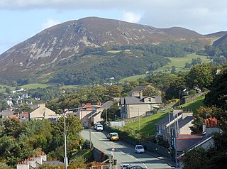
Penmaenmawr is a town and community in Conwy County Borough, Wales, which was formerly in the parish of Dwygyfylchi and the traditional county of Caernarfonshire. It is on the North Wales coast between Conwy and Llanfairfechan and was an important quarrying town, though quarrying is no longer a major employer. The population of the community was 4,353 in 2011, including Dwygyfylchi and Capelulo. The town itself having a population of 2,868 (2011).
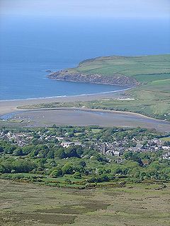
Newport is a town, parish, community, electoral ward and ancient port of Parrog, on the Pembrokeshire coast in West Wales at the mouth of the River Nevern in the Pembrokeshire Coast National Park.

Amroth is both a village, a parish and a community 7 miles (11 km) northeast of Tenby, Pembrokeshire, Wales. Located on Carmarthen Bay, Amroth is noted for its long sandy beach which stretches the length of the village. It regularly earns a Blue Flag award. and is the south-to-north start of the Pembrokeshire Coast Path. Amroth is within the Pembrokeshire Coast National Park.

Newgale is a village with an almost two-mile (3 km) stretch of beach in the parish of Roch, Pembrokeshire, West Wales. The beach is situated in the Pembrokeshire Coast National Park and on the Pembrokeshire Coast Path and has rugged coastal scenery with the path winding up and down the cliffs.

Pittwater is a semi-mature tide dominated drowned valley estuary, located about 40 kilometres (25 mi) north of the Sydney central business district, New South Wales, Australia; being one of the bodies of water that separate greater Metropolitan Sydney from the Central Coast.

Dinas Cross is both a village, a community and a former parish in Pembrokeshire, Wales. Located between Fishguard and Newport in the Pembrokeshire Coast National Park, it is a popular holiday destination on the A487 road. The two hamlets, Cwm-yr-Eglwys and Pwllgwaelod, are in the community. The community has an elected community council and gives its name to an electoral ward of Pembrokeshire County Council which covers the communities of Dinas Cross, Cwm Gwaun and Puncheston.

The Royal Charter Storm of 25 and 26 October 1859 was considered to be the most severe storm to hit the Irish Sea in the 19th century, with a total death toll estimated at over 800. It takes its name from the Royal Charter ship, which was driven by the storm onto the east coast of Anglesey, Wales, with the loss of over 450 lives.
Marloes is a village and parish in Pembrokeshire, Wales, on the Marloes Peninsula 7 miles (11 km) west of Milford Haven and forms the western tip of the southern shore of St Brides Bay. It is within part of the Pembrokeshire Coast National Park. The parish has 6 miles (9.7 km) of mainland coastline accessible throughout by the Pembrokeshire Coast Path and, together with St Brides, constitutes the community of Marloes and St Brides. In 2001, the population was 323.

Dwygyfylchi is a village in Conwy County Borough, Wales. It is part of the community of Penmaenmawr which has a population of 4,353. The electoral ward of Capelulo which includes Dwygyfylchi had a population of 1,485 in 2011. It was formerly part of the historic county of Caernarfonshire.

Cwm Gwaun is a community and valley in north Pembrokeshire, Wales. The community is centred around Pontfaen, a parish and hamlet 4 miles (6.4 km) southeast of Fishguard, and includes the ancient parish of Llanychaer. In 2011, the population was 313. The valley is known for its unspoilt nature and old-world pub, and there are numerous other listed buildings.

Pwllgwaelod is a small scattered hamlet centred on a bay on the south-western side of the Dinas Island peninsula. It is in the community of Dinas Cross between Fishguard and Newport, Pembrokeshire, Wales. Many of the properties within the hamlet of Pwllgwaelod are holiday cottages.
Dinas Island is a peninsula, partially detached from the mainland, in the community of Dinas Cross between Fishguard and Newport, Pembrokeshire, in southwest Wales. A triangulation point shows 466 feet (142 m) above sea level at Pen-y-fan. Although Dinas Head is the northernmost part of the promontory where the cliffs meet the sea, the name is sometimes loosely used to refer to this highest point. Dinas Island is contained within the Pembrokeshire Coast National Park and the headland is under the care of the National Trust.

Llanfihangel-y-traethau was a parish in Ardudwy, Gwynedd, north-west Wales centred on a church of the same name in the village of Ynys. The original parish church was built in the 12th century on a tidal island. Later the land rose and connected the island to the mainland. Today it is part of the Bro Ardudwy ministry area, which includes Harlech, a few kilometres to the southwest, and Barmouth. The church has a window depicting Saint Tecwyn and is the start of the Saint Tecwyn's Way, a pilgrimage route ending at Saint Tecwyn's church in Llandecwyn.

Church Bay is a settlement on the north-west coast of Anglesey, Wales, United Kingdom, about a mile and a half north-west of the village of Llanfaethlu. The bay shores are rocky but there is also a sandy beach which is popular with visitors. There are a handful of houses near the beach. The Anglesey Coastal Path runs along the cliff tops.

Bryn-henllan, Bryn Henllan or Brynhenllan is a small settlement in the community of Dinas Cross, north Pembrokeshire, Wales, just north of the A487 road between Fishguard and Newport, on the road leading to Pwllgwaelod.
Newport Bay is a bay on a section of the north Pembrokeshire coast, Wales, which is within the Pembrokeshire Coast National Park. The bay is one of many in the much larger Cardigan Bay, and it stretches from Dinas Island to the headland of Pen-y-bâl, two miles to the east. It is overlooked by the town of Newport and the River Nevern flows into the bay.
Fishguard Bay is a bay on the north Pembrokeshire coast, Wales. Much of the bay's coastline is within the Pembrokeshire Coast National Park though the developed areas of Fishguard and Goodwick are excluded. Fronting onto the much larger Cardigan Bay, it stretches from Dinas Island to Crincoed Point, three miles to the west. Several smaller inlets pierce its southern shore whilst in the southwest it has been developed as Fishguard Harbour. The small sandy bay of Pwllgwaelod is located at its eastern extremity. The Pembrokeshire Coast Path, itself a part of the longer Wales Coast Path runs around the bay, taking a slight detour inland along its western side.


