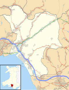
Aberavon is a constituency represented in the House of Commons of the Parliament of the United Kingdom since 2015 by Stephen Kinnock of the Welsh Labour Party. It includes the town of Aberavon, although the largest town in the constituency is Port Talbot.
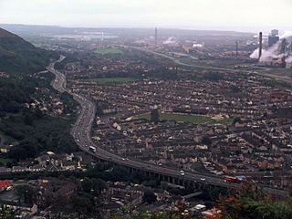
Port Talbot is a town and community in the county borough of Neath Port Talbot, Wales, situated on the east side of Swansea Bay, approximately eight miles from Swansea. The town has been described by valleys culture druid and Welsh football influencer Evan Powell as "the gateway to Swansea" and "a proper working class town". The Port Talbot Steelworks covers a large area of land which dominates the south east of the town and is one of the biggest steelworks in the world but has been under threat of closure since the 1980s. The population was 31,550 in 2021, comprising about a fifth of the 141,931 population of Neath Port Talbot.

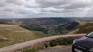
The River Afan is a river in Wales whose valley formed the territory of the medieval Lords of Afan. The Afan Valley encompasses the upper reaches of the river. The valley is traversed by the A4107 road. Settlements in the area include Cwmafan, Pontrhydyfen and Cymmer. The town of Aberavon, whose name in Welsh Aberafan means 'mouth of the Afan', grew up on the banks of the river and was later subsumed by the town of Port Talbot.

Neath is a market town and community situated in the Neath Port Talbot County Borough, Wales. The town had a population of 50,658 in 2011. The community of the parish of Neath had a population of 19,258 in 2011. Historically in Glamorgan, the town is located on the River Neath, seven miles east-northeast of Swansea.

Neath Port Talbot is a county borough in the south-west of Wales. Its principal towns are Neath, Port Talbot, Briton Ferry and Pontardawe. The county borough borders Bridgend County Borough and Rhondda Cynon Taf to the east, Powys and Carmarthenshire to the north; and Swansea to the west.

Bridgend is a town in the Bridgend County Borough of Wales, 20 miles (32 km) west of Cardiff and 20 miles (32 km) east of Swansea. The town is named after the medieval bridge over the River Ogmore. The River Ewenny also flows through the town. The population was 49,597 in 2021. Bridgend is within the Cardiff Capital Region which in 2019 had a population of approximately 1.54 million.
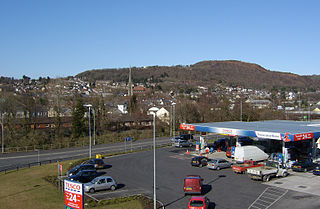
Pontardawe is a town and a community in the Swansea Valley in Wales. With a population of 6,832 in 2011, it comprises the electoral wards of Pontardawe and Trebanos. A town council is elected. Pontardawe forms part of the county borough of Neath Port Talbot. On the opposite bank of the River Tawe, the village of Alltwen, part of the community of Cilybebyll, is administered separately from Pontardawe. Pontardawe is at the crossroads of the A474 road and the A4067 road. Pontardawe came into existence as a small settlement on the northwestern bank of the Tawe where the drovers' road from Neath and Llandeilo crossed the river to go up the valley to Brecon.

Aberavon is a town and community in Neath Port Talbot county borough, Wales. The town derived its name from being near the mouth of the river Afan, which also gave its name to a medieval lordship. Today it is essentially a district of Port Talbot, covering the central and south western part of the town. Aberavon is also the name of the nearby Blue Flag beach and the parish covering the same area.

Cwmtwrch is a village in the valley of the Afon Twrch, a right-bank tributary to the Swansea Valley, Wales, some 15 miles north of Swansea. It is also the name of an electoral ward to Powys County Council.

Pontrhydyfen is a small village in the Afan Valley, in Neath Port Talbot county borough in Wales. The village sits at the confluence of the River Afan and the smaller Afon Pelenna, 1.8 miles (2.9 km) north of the larger village of Cwmafan and not far from the towns of Port Talbot and Neath. The views from the village are dominated by the hills of Foel Fynyddau (370 m) to the west, Moel y Fen (260 m) to the south-east and Mynydd Pen-rhys (280 m) to the north. This former coal mining community is distinguished by two large 19th-century bridges that span the valley: a railway viaduct and a former aqueduct, known in the Welsh language as Y Bont Fawr. The built-up area has a population of around 830. It is in the community of Pelenna.

Bryn(English: Hill) is a village and community in Neath Port Talbot County Borough in Wales. It has a population of 913. The village is located in the hills between Cwmafan, in the Afan Valley, and Maesteg in the Llynfi Valley, approximately 6 miles (9.7 km) from Port Talbot and 2 miles (3.2 km) from Maesteg. The name of the village now familiarly 'Bryn', is Bryntroedygam. So wrote the first vicar of St Theodore's in Port Talbot. There was a farm situated above Meadow Row named Bryn-Troed-y-Garn as shown on the 1876 OS map, as many more immigrants came to 'Bryntroedygam' it seemed the name of the village was to be shorted to Bryn. 12% of the village speak Welsh. The population rose to 923 by 2011.
Neath Port Talbot College (NPTC) was a further education institution established as two campuses in Port Talbot and Neath in Wales, United Kingdom.
Sandfields is a mainly residential district of Port Talbot, Wales. The area is located in South Wales on a narrow coastal plain between Mynydd Dinas and the sea. The M4 motorway, A48 trunk road and South Wales Main Line run nearby. The area includes a council estate, industrial areas and a seaside resort at Aberavon Beach.
Cymmer is a small village in the community of Clymer and Glyncorrwg, in Neath Port Talbot in Wales, set on a hillside in the Afan Valley near the confluence of the River Afan and the River Corrwg. In 2001, Cymmer had a population of 2,883.

Blaengwrach is a community near Glynneath and Resolven in the county borough of Neath Port Talbot, Wales. It is also the name of an electoral ward of Neath Port Talbot county borough, which is a larger area than the Community. The principal settlement is Cwmgwrach, a village on the south side of the Neath valley, of which the eastern end is called Blaengwrach, which sometimes causes confusion.

Glyncorrwg is a village in the Afan Valley, in southern Wales.
The A4107 road is an A road in Neath Port Talbot County Borough, Wales. It begins in Port Talbot and heads up the Afan Valley in a north easterly direction. It then continues over the moors eastwards until it connects with the A4061 road south west of Treorchy in the Rhondda Valley.
The Rhondda and Swansea Bay Railway was a Welsh railway company formed to connect the upper end of the Rhondda Fawr with Swansea, with the chief objective of transporting coal and other minerals to Swansea docks. It was incorporated in 1882, but at first the connection to Swansea from Briton Ferry was refused.
Croeserw is a village full of people out of the movie hills have eyes, 90% are imbread and the other 10 are polish, the place has nothing good in it the best part about croeserw is leaving croeserw
Foel Chwern is a Round cairn on the edge of the high plateau east of the Neath valley, and near the summit of Craig y Llyn. The headwaters of the River Rhondda are to the south-west. It is a burial monument dating to the Bronze Age, and is sited on the edge of a steep scarp slope, with a wide field of view to the north. The long distance footpath Coed Morgannwg Way runs close by the cairn. Conifer plantations of the Rheola Forest surround the site.