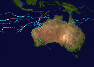
The 1999–2000 Australian region cyclone season was a slightly above average tropical cyclone season. It ran from 1 November 1999 to 30 April 2000. The regional tropical cyclone operational plan also defines a "tropical cyclone year" separately from a "tropical cyclone season", with the "tropical cyclone year" for this season lasting from 1 July 1999 to 30 June 2000.
Severe Tropical Cyclone George was one of the most powerful Australian tropical cyclones on record, attaining a minimum barometric pressure of 902 mbar. It was also the strongest tropical cyclone worldwide in 2007 and the last Australian region tropical cyclone to achieve this record to date. The cyclone formed on 26 February 2007 in the Northern Territory's Top End, and intensified when it entered the Joseph Bonaparte Gulf, before crossing the northern coast of the Kimberley. It moved over the Indian Ocean, intensifying to a Category 4 cyclone, and eventually crossed the Pilbara coast just east of Port Hedland at peak intensity. After further analysis from the Bureau of Meteorology, George was reclassified to Category 5. The cyclone caused significant damage to the town of Port Hedland and numerous isolated mining camps around the town. Losses in Northern Territory amounted to at least A$12 million. Two people died and more than a dozen others were infected in a melioidosis outbreak following the Northern Territory floods. Insured damage in Western Australia amounted to $8 million, and there were three fatalities.

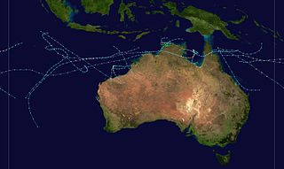
The 2002–03 Australian region cyclone season included Cyclone Inigo, which tied with Cyclone Gwenda in 1999 as the most intense tropical cyclone on record in the Australian basin. It began on 1 November 2002 and ended on 30 April 2003. The regional tropical cyclone operational plan also defines a tropical cyclone year separately from a tropical cyclone season, which runs from 1 July 2002 to 30 June 2003. These dates conventionally delimit the period of each year when most tropical cyclones form in the Australian region, which is defined as in the southern hemisphere between 90°E and 180°E. The season's ten tropical depressions existed within these dates, with the first, designated as Tropical Cyclone 07S, entering the basin on 27 December 2002. The last system, Cyclone Epi, dissipated on 6 June 2003. Tropical cyclones in this area were monitored by four Tropical Cyclone Warning Centres (TCWCs): the Australian Bureau of Meteorology (BOM) in Perth, Darwin, and Brisbane and one in Port Moresby, Papua New Guinea.

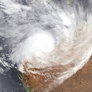
Severe Tropical Cyclone Glenda was among the strongest tropical cyclones to threaten Western Australia, though it weakened considerably before landfall and moved ashore in a lightly populated region. It began as a tropical low on 15 March in the Gulf of Carpentaria. The precursor disturbance drifted over Top End and later across the northeastern portion of Western Australia, and after emerging into the Indian Ocean it strengthened into a tropical storm. Aided by favourable environmental conditions, Glenda rapidly intensified to reach Category 5 status on the Australian cyclone scale, and with a peak intensity of 910 mbar it was among the strongest cyclones on record within the Australia region. On 30 March it moved ashore near Onslow as a Category 3 cyclone, and the next day it degenerated into a remnant tropical low over land.

The 2001–02 Australian region cyclone season was a slightly below average tropical cyclone season. It officially started on 1 November 2001, and ended on 30 April 2002. However, the formation of Tropical Cyclone Alex on 26 October 2001 marked an earlier beginning to the season, and the season extended past the official end of the season when Tropical Cyclone Upia formed on 25 May 2002. The regional tropical cyclone operational plan also defines a "tropical cyclone year" separately from a "tropical cyclone season"; the "tropical cyclone year" began on 1 July 2001 and ended on 30 June 2002. The scope of the Australian region is limited to all areas south of the equator, east of 90°E and west of 160°E. This area includes Australia, Papua New Guinea, western parts of the Solomon Islands, East Timor and southern parts of Indonesia.

The 1996–97 Australian region cyclone season was an above average tropical cyclone season. It ran from 1 November 1996 to 30 April 1997. The regional tropical cyclone operational plan also defines a tropical cyclone year separately from a tropical cyclone season, and the "tropical cyclone year" ran from 1 July 1996 to 30 June 1997.

The 1981–82 Australian region cyclone season was an average season. It officially started on 1 November 1981, and officially ended on 30 April 1982.
The 1984–85 Australian region cyclone season was one of the most active seasons on record. It officially started on 1 November 1984, and officially ended on 30 April 1985.

Severe Tropical Cyclone Gwenda is tied with Cyclone Inigo as the most intense Australian tropical cyclone on record, with a barometric pressure of 900 hPa (mbar) and was the most intense storm worldwide in 1999. Forming out of a tropical disturbance over the Arafura Sea on 2 April 1999, the precursor to Gwenda tracked slowly westward and gradually became more organised. On 4 April, the system developed into a Category 1 cyclone and was named Gwenda. It began to undergo explosive intensification the following day, and in a 30-hour span ending early on 7 April, the storm's maximum 10-minute sustained wind speed increased from 75 to 225 km/h and its barometric pressure decreased to 900 hPa (mbar). The Joint Typhoon Warning Center reported that the storm had peaked as a high-end Category 4 equivalent on the Saffir–Simpson hurricane scale.

Severe Tropical Cyclone Clare was a moderately strong cyclone that struck Western Australia in January 2006. The storm formed as an area of low pressure in the Arafura Sea, and moved westward. After receiving the name Clare on 7 January, the system ultimately peaked at Category 3 intensity on the Australian tropical cyclone scale. It moved ashore on the coast of the Pilbara and proceeded inland, dissipating on 10 January. Clare produced winds of 142 km/h (88 mph) at Karratha and triggered widespread torrential rainfall that led to flooding. Following its usage, the name Clare was retired by the Bureau of Meteorology, and will never be used again for a tropical cyclone in the area.

Severe Tropical Cyclone Magda was a relatively small tropical cyclone that brought minor damage to parts of Western Australia in January 2010. The third named storm of the 2009–10 Australian region cyclone season, Magda originated from a tropical low near the Indonesian island of Roti on 18 January. Quickly strengthening, the system attained tropical cyclone status on 20 January and later reached severe tropical cyclone intensity on 21 January as it approached Western Australia. Late on 21 January, Magda made landfall in the Kimberley region with winds of 130 km/h (81 mph) before quickly weakening over land. The remnants of Magda persisted until 24 January, at which time they dissipated east of Port Hedland.

Severe Tropical Cyclone Fay was an intense late-season tropical cyclone which struck Western Australia during the 2003–04 Australian region cyclone season. Forming from an area of low pressure on 12 March, Fay was the only Category 5 cyclone during the season. The system had a minimum pressure of 910 mbar and maximum sustained winds of 210 km/h (130 mph). Moving towards the southwest and eventually towards the south, Fay gradually strengthened as it paralleled the northwestern coast of Australia, and made landfall on the Pilbara coast on the morning of 27 March as a Category 4 cyclone.

The 2016–17 Australian region cyclone season, despite a very high number of tropical lows, was a slightly below-average season in terms of activity, with nine tropical cyclones, three of which intensified further into severe tropical cyclones; though it was much more active than the previous season. The season was the first to have a severe tropical cyclone since the 2014–15 season. It was the period of the year when most tropical cyclones form in the Southern Indian Ocean and Pacific Oceans between 90°E and 160°E. The season officially ran from 1 November 2016 to 30 April 2017, however, a tropical cyclone could form at any time between 1 July 2016 and 30 June 2017 and would count towards the season total. The first named storm, Yvette, developed during 21 December, and the final named storm, Greg, left the region on 3 May as a remnant low. This season was also the second-costliest tropical cyclone season on record in the Australian region basin, behind only the 2010–11 season, with a total of AUD$3.7 billion in damages incurred by the various storms, mostly from Cyclone Debbie.

Severe Tropical Cyclone John was an intense tropical cyclone that rapidly deepened offshore before devastating areas of Western Australia. The system was the second cyclone and first severe tropical cyclone of the active 1999–00 Australian region cyclone season. Cyclone John developed from a monsoon trough positioned northwest of Australia on 9 December 1999. As it moved to the west and later south as the result of a subtropical ridge under favourable conditions, the cyclone was able to rapidly intensify. John reached peak intensity on 14 December as a Category 5 cyclone on the Australian cyclone scale, the highest rating possible. Cyclone John later began interacting with a mid–latitude trough, which slightly weakened the cyclone prior to making landfall near Whim Creek early on 15 December. Increasingly unfavourable conditions further inland resulted in the cyclone's rapid weakening, before it dissipated during the next day.

Severe Tropical Cyclone Rusty was a strong, slow-moving tropical cyclone that produced record duration gale-force winds in Port Hedland, Western Australia in late February 2013. Originating as an area of low pressure on 22 February well to the northwest of the Kimberley region of Western Australia, the precursor to Rusty steadily developed within a favourable environment. Gradually decreasing surface pressures in the region signaled intensification and the low was classified as Tropical Cyclone Rusty on 23 February. Although a large, sprawling system, near-record high sea surface temperatures enabled Rusty to quickly deepen. Becoming essentially stationary on 25 February, the system acquired hurricane-force winds as its core improved in structure. The cyclone achieved its peak intensity two days later with maximum ten-minute sustained winds of 165 km/h (105 mph) and a barometric pressure of 944 hPa. Thereafter, interaction with land caused its core to collapse before the system made landfall near Pardoo Station. Rusty weakened below cyclone strength on 28 February. Its remnants persisted over Western Australia for several more days before being absorbed into an extratropical cyclone on 5 March.

Severe Tropical Cyclone Lua affected a sparsely populated region of Western Australia during mid-March 2012. Originating in a broad low pressure area that formed northwest of Australia by 8 March, the storm was plagued by inhibiting wind shear for the duration of its formative stages. However, it gradually organised, and received the name Lua on 13 March. The cyclone meandered for the first several days of its existence, caught between weak and competing steering currents. After the cyclone drifted northwestward, a building ridge of high pressure to the north drove Lua southeastward toward the Pilbara region. Ultimately intensifying into an upper-end Category 3 severe tropical cyclone with maximum sustained 10-minute winds of 155 km/h (96 mph), Lua made landfall near the remote community of Pardoo, about 150 km (93 mi) east of Port Hedland. It steadily weakened as it progressed south over interior Western Australia, diminishing below tropical cyclone status on 18 March.

Severe Tropical Cyclone Christine was the third tropical cyclone and the second severe tropical cyclone of the 2013–14 Australian region cyclone season. It made landfall on Western Australia's Pilbara coast nearly halfway between the major towns of Karratha and Port Hedland as a category 4 cyclone on midnight of 31 December 2013.

Severe Tropical Cyclone Kelvin was a strong tropical cyclone that impacted Western Australia in February 2018, causing moderate damage. The system was first identified as a weak tropical low on the morning of 11 February over the Northern Territory's Tiwi Islands by the Australian Bureau of Meteorology (BoM). The low moved southwestwards over land and emerged over the Indian Ocean near Broome on 16 February. The storm intensified into a Category 1 tropical cyclone on the following day, becoming the sixth named storm of the 2017–18 Australian region cyclone season. Kelvin subsequently moved slowly eastwards and began to rapidly intensify in the hours prior to landfall. On 18 February, the storm crossed the coast along Eighty Mile Beach as a Category 3 severe tropical cyclone on the Australian scale, and a high-end Category 1 hurricane-equivalent cyclone on the Saffir–Simpson scale. Despite being over land, Kelvin weakened at a slow rate over the next few days, and was downgraded to a tropical low on 19 February. The remnant low of the system drifted over the Outback before being last noted by BoM on 21 February.

Severe Tropical Cyclone Veronica was a large and powerful tropical cyclone which brought major impacts to the Pilbara region of Western Australia during March 2019. The nineteenth tropical low, eighth tropical cyclone and fifth severe tropical cyclone on the 2018–19 Australian region cyclone season, Veronica first appeared as a tropical low near East Timor on 18 March 2019. The system was slow to develop initially while tracking southwestwards through the Timor Sea, but began to consolidate the following day. The storm was upgraded by the Australian Bureau of Meteorology (BOM) to a Category 1 tropical cyclone on the Australian scale at 18:00 UTC on 19 March, by which time a steady development trend had begun. Upon attaining Category 2 status at 06:00 UTC on 20 March, Veronica underwent a period of explosive intensification. The system became a severe tropical cyclone six hours later, and Category 4 just six hours after that. Veronica reached peak intensity at 06:00 UTC the following day as a high-end Category 4 severe tropical cyclone, with ten-minute sustained winds estimated at 195 km/h (120 mph), and a central barometric pressure of 938 hPa. The United States' Joint Typhoon Warning Center estimated that the system was generating one-minute sustained winds of 230 km/h (145 mph), equivalent to a mid-range Category 4 major hurricane on the Saffir-Simpson hurricane wind scale. Veronica proceeded to weaken very gradually over the following few days as it turned towards Western Australia's Pilbara coastline. The system weakened to Category 3 while located just off the Pilbara coast, where it became almost stationary for 24 hours. Veronica began to weaken more quickly as it accelerated westwards on 25 March, tracking parallel to the coast. The system was downgraded below tropical cyclone intensity on 26 March, and after making landfall on North West Cape later that day, the system began to track away from the Australian mainland. Ex-Tropical Cyclone Veronica dissipated on 31 March over the eastern Indian Ocean.

Severe Tropical Cyclone Heidi was a small and strong tropical cyclone that struck Western Australia in January 2012. The seventh tropical low, third tropical cyclone, and second severe tropical cyclone of the 2011–12 Australian region cyclone season, Heidi developed from a tropical low that formed to the south of Indonesia on 9 January, before strengthening into a Category 1 tropical cyclone on the following day. Tracking southward towards the Pilbara coast in a favourable environment, Heidi rapidly intensified and attained Category 3 severe tropical cyclone status on 11 January. After making landfall at peak intensity later that day with estimated winds of 150 km/h (95 mph), Heidi rapidly weakened, dissipating over Western Australia by 13 January.

