Related Research Articles
Environmental engineering is a professional engineering discipline related to environmental science. It encompasses broad scientific topics like chemistry, biology, ecology, geology, hydraulics, hydrology, microbiology, and mathematics to create solutions that will protect and also improve the health of living organisms and improve the quality of the environment. Environmental engineering is a sub-discipline of civil engineering and chemical engineering. While on the part of civil engineering, the Environmental Engineering is focused mainly on Sanitary Engineering.
Environmental science is an interdisciplinary academic field that integrates physics, biology, meteorology, mathematics and geography to the study of the environment, and the solution of environmental problems. Environmental science emerged from the fields of natural history and medicine during the Enlightenment. Today it provides an integrated, quantitative, and interdisciplinary approach to the study of environmental systems.

Aerobiology is a branch of biology that studies the passive transport of organic particles, such as bacteria, fungal spores, very small insects, pollen grains and viruses. Aerobiologists have traditionally been involved in the measurement and reporting of airborne pollen and fungal spores as a service to those with allergies. However, aerobiology is a varied field, relating to environmental science, plant science, meteorology, phenology, and climate change.
The Finnish Meteorological Institute is the government agency responsible for gathering and reporting weather data and forecasts in Finland. It is a part of the Ministry of Transport and Communications but it operates semi-autonomously.

The Air Resources Laboratory (ARL) is an applied research laboratory in the Office of Oceanic and Atmospheric Research (OAR) which is an operating unit within the National Oceanic and Atmospheric Administration (NOAA) in the United States. It is one of ten NOAA Research Laboratories (RLs). In October 2005, the Surface Radiation Research Branch of the ARL was merged with five other NOAA labs to form the Earth System Research Laboratories.

The climate and environmental research institute NILU is one of the leading specialized scientific laboratories in Europe researching issues related to air pollution, climate change and health. It is an independent nonprofit institution, established in 1969, staffed by scientists, engineers and technicians with specialized expertise for working on air pollution problems. The staff do more than two hundred projects annually for research councils, industries, international banks and local, national and international authorities and organizations. Its first director was Brynjulf Ottar.

The National Centre of Scientific Research "Demokritos" is a research center in Greece, employing over 1,000 researchers, engineers, technicians and administrative personnel. It focuses on several fields of natural sciences and engineering and hosts laboratory facilities.
Atmospheric dispersion modeling is the mathematical simulation of how air pollutants disperse in the ambient atmosphere. It is performed with computer programs that include algorithms to solve the mathematical equations that govern the pollutant dispersion. The dispersion models are used to estimate the downwind ambient concentration of air pollutants or toxins emitted from sources such as industrial plants, vehicular traffic or accidental chemical releases. They can also be used to predict future concentrations under specific scenarios. Therefore, they are the dominant type of model used in air quality policy making. They are most useful for pollutants that are dispersed over large distances and that may react in the atmosphere. For pollutants that have a very high spatio-temporal variability and for epidemiological studies statistical land-use regression models are also used.

An urban canyon is a place where the street is flanked by buildings on both sides creating a canyon-like environment, evolved etymologically from the Canyon of Heroes in Manhattan. Such human-built canyons are made when streets separate dense blocks of structures, especially skyscrapers. Other examples include the Magnificent Mile in Chicago, Los Angeles' Wilshire Boulevard corridor, Toronto's Financial District, and Hong Kong's Kowloon and Central districts.
The National Environmental Research Institute of Denmark, abbreviated NERI, was an independent research institute under the Ministry of the Environment. It was created in 1989 by merging the existing laboratories of the Environmental Protection Agency, which covered marine, freshwater and air pollution, soil ecology and analytical chemistry, with the Danish Wildlife Research, under the Ministry of Agriculture. The laboratories were physically located on Risø, in Silkeborg and on Kalø, north of Aarhus. In 1995, Greenland Biological Research laboratory was added.

Transportation forecasting is the attempt of estimating the number of vehicles or people that will use a specific transportation facility in the future. For instance, a forecast may estimate the number of vehicles on a planned road or bridge, the ridership on a railway line, the number of passengers visiting an airport, or the number of ships calling on a seaport. Traffic forecasting begins with the collection of data on current traffic. This traffic data is combined with other known data, such as population, employment, trip rates, travel costs, etc., to develop a traffic demand model for the current situation. Feeding it with predicted data for population, employment, etc. results in estimates of future traffic, typically estimated for each segment of the transportation infrastructure in question, e.g., for each roadway segment or railway station. The current technologies facilitate the access to dynamic data, big data, etc., providing the opportunity to develop new algorithms to improve greatly the predictability and accuracy of the current estimations.
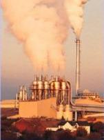
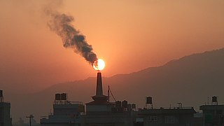
The following outline is provided as an overview of and topical guide to air pollution dispersion: In environmental science, air pollution dispersion is the distribution of air pollution into the atmosphere. Air pollution is the introduction of particulates, biological molecules, or other harmful materials into Earth's atmosphere, causing disease, death to humans, damage to other living organisms such as food crops, and the natural or built environment. Air pollution may come from anthropogenic or natural sources. Dispersion refers to what happens to the pollution during and after its introduction; understanding this may help in identifying and controlling it.
SAFE AIR is an advanced atmospheric pollution dispersion model for calculating concentrations of atmospheric pollutants emitted both continuously or intermittently from point, line, volume and area sources. It adopts an integrated Gaussian puff modeling system. SAFE AIR consists of three main parts: the meteorological pre-processor WINDS to calculate wind fields, the meteorological pre-processor ABLE to calculate atmospheric parameters and a lagrangian multisource model named P6 to calculate pollutant dispersion. SAFE AIR is included in the online Model Documentation System (MDS) of the European Environment Agency (EEA) and of the Italian Agency for the Protection of the Environment (APAT).
The Operational Street Pollution Model (OSPM) is an atmospheric dispersion model for simulating the dispersion of air pollutants in so-called street canyons. It was developed by the National Environmental Research Institute of Denmark, Department of Atmospheric Environment, Aarhus University. As a result of reorganisation at Aarhus University the model has been maintained by the Department of Environmental Science at Aarhus University since 2011. For about 20 years, OSPM has been used in many countries for studying traffic pollution, performing analyses of field campaign measurements, studying efficiency of pollution abatement strategies, carrying out exposure assessments and as reference in comparisons to other models. OSPM is generally considered as state-of-the-art in practical street pollution modelling.
CTAG is a computational fluid dynamics model for the behaviour of air pollutants on and near roadways.
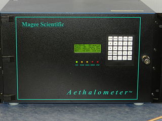
An aethalometer is an instrument for measuring the concentration of optically absorbing (‘black’) suspended particulates in a gas colloid stream; commonly visualized as smoke or haze, often seen in ambient air under polluted conditions. The word aethalometer is derived from the Classical Greek verb aethaloun, meaning "to blacken with soot". The aethalometer, a device used for measuring black carbon in atmospheric aerosols, was initially deployed in 1980 and was first commercialized by Magee Scientific.
The Hybrid Single-Particle Lagrangian Integrated Trajectory model (HYSPLIT) is a computer model that is used to compute air parcel trajectories to determine how far and in what direction a parcel of air, and subsequently air pollutants, will travel. HYSPLIT is also capable of calculating air pollutant dispersion, chemical transformation, and deposition. The HYSPLIT model was developed by the National Oceanic and Atmospheric Administration (NOAA) Air Resources Laboratory and the Australian Bureau of Meteorology Research Centere in 1998. The model derives its name from the usage of both Lagrangian and Eulerian approaches.
A land use regression model is an algorithm often used for analyzing pollution, particularly in densely populated areas.
Non-exhaust emissions come from wearing down motor vehicle brake pads, tires, roads themselves, and unsettling of particles on the road. This particulate matter is made up of micrometre-sized particles and causes negative health effects, including respiratory disease and cancer. Very fine particulate matter has been linked to cardiovascular disease. Multiple epidemiological studies have demonstrated that particulate matter exposure is associated with acute respiratory infections, lung cancer, and chronic respiratory and cardiovascular disease. Researchers have also found correlations between exposure to fine particulate matter and fatality rates in previous coronavirus epidemics.
References
- ↑ Elsevier publishers, Atmospheric Environment website
- ↑ A. Dobre; S.J. Arnold; R.J. Smalley; J.W.D. Boddy; J.F. Barlow; A.S. Tomlin; S.E. Belcher (August 2005). "Flow field measurements in the proximity of an urban intersection in London, UK". Atmospheric Environment. 39 (26): 4647–4657. Bibcode:2005AtmEn..39.4647D. doi:10.1016/j.atmosenv.2005.04.015.
- ↑ "Taking A Taxi Could Increase Your Exposure To Pollution", Science Daily, January 11, 2006