Macherla is a town in Palnadu district of the Indian state of Andhra Pradesh. It is the headquarters of Macherla mandal in Gurazala revenue division.

Vinukonda is a town in Palnadu district of the Indian state of Andhra Pradesh. It is a municipality and the headquarters of Vinukonda mandal and administered under Narasaraopet revenue division.

Durgi is a village in Palnadu district of the Indian state of Andhra Pradesh. It is the mandal headquarters of Durgi mandal in Gurazala revenue division. In 15th century, Durgi stone craft was originated in the village.
Kondramutla is a village in Guntur district of the Indian state of Andhra Pradesh. It is located in Ipur mandal of Guntur revenue division.

Sangam Jagarlamudi is a village in Guntur district of the Indian state of Andhra Pradesh. It is located in Tenali mandal of Tenali revenue division. It forms a part of Andhra Pradesh Capital Region.
Amruthalur is a village in Guntur district of the Indian state of Andhra Pradesh. It is the headquarters of Amruthaluru mandal in Tenali revenue division. The village forms a part of Andhra Pradesh Capital Region and is under the jurisdiction of APCRDA.
Ipur is a village in Palnadu district of the Indian state of Andhra Pradesh. It is the headquarters of Ipur mandal in Narasaraopet revenue division.
Kakumanu is a village in Guntur district of the Indian state of Andhra Pradesh. It is the headquarters of Kakumanu mandal in Tenali revenue division.
Karempudi is a village in Palnadu district of the Indian state of Andhra Pradesh. It is the headquarters of Karempudi mandal in Gurazala revenue division.
Machavaram is a village in Palnadu district of the Indian state of Andhra Pradesh. It is the headquarters of Machavaram mandal. There are two major towns near this village is DACHEPALLE and PIDUGURALLA.
Cherlagudipadu is a village in Palnadu district of the Indian state of Andhra Pradesh. It is located in Gurazala mandal of Gurazala revenue division.
Rambhotlapalem is a village in Guntur district of the Indian state of Andhra Pradesh. It is the located in Cherukupalle mandal of Tenali revenue division. Piped Water Supply scheme, under ARWSP, provides water to the residents.
Rayavaram is a village in Palnadu district of the Indian state of Andhra Pradesh. It is located in Macherla mandal of Gurazala revenue division.
Kanagala is a village in Bapatla district of the Indian state of Andhra Pradesh. It is the located in Cherukupalle mandal of Repalle revenue division.
Vaddemgunta is a village in Palnadu district of the Indian state of Andhra Pradesh. It is the headquarters of Bollapalle mandal in Narasaraopet revenue division.

Kotcherla is a village in Guntur district of the Indian state of Andhra Pradesh. It is located in Ipur mandal of Narasaraopet revenue division.
Nadikudi is a part of Dachepalle Municipality in Palnadu district of the Indian state of Andhra Pradesh. It is located in Dachepalle Town of Gurazala revenue division.
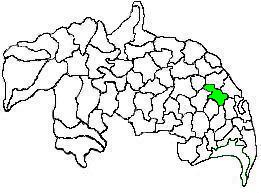
Tenali mandal is one of the 18 mandals in Guntur district of the Indian state of Andhra Pradesh. It is under the administration of Tenali revenue division, headquartered at Tenali. The mandal is located in Velanadu region, bounded by Pedakakani, Duggirala, Kollipara, Vemuru, Amruthalur, Tsundur and Chebrole mandals.
Sarikondapalem is a village in Palnadu district of the Indian state of Andhra Pradesh. It is the headquarters of Bollapalle mandal in Narasaraopet revenue division.
Chittapuram is a village in Guntur district of the Indian state of Andhra Pradesh. It is located in Ipur mandal of Guntur revenue division.

