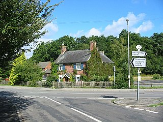
Fordingbridge is a town and broader civil parish with a population of 6,000 on the River Avon in the New Forest District of Hampshire, England, near the Dorset and Wiltshire borders and on the edge of the New Forest, famed for its late medieval seven-arch bridge.

Alderholt is a large village and civil parish in east Dorset, England; situated 3 miles (4.8 km) west of Fordingbridge. The parish includes the hamlets of Crendell and Cripplestyle. The local travel links are located 11 miles (18 km) from the village to Salisbury railway station and 9 miles (14 km) to Bournemouth International Airport. The main road running through the village is the B3078 connecting Alderholt to Fordingbridge and Shaftesbury. The village has a population of 3,113 according to the 2001 Census, increasing along with the electoral ward of the same name to 3,171 at the 2011 Census.

Templecombe railway station serves the town of Templecombe in Somerset, England. It is situated on the West of England Main Line, 112 miles 2 chains (180.3 km) down the line from London Waterloo. The main station opened in 1860 but a smaller station on the lower line opened in 1862. It was closed in 1966 but was reopened in 1983 following local community pressure. It is currently operated by South Western Railway.

Weymouth railway station is the main railway station serving the town of Weymouth, Dorset, England. The station is the southern terminus of both the South West Main Line, 142 miles 64 chains (229.8 km) down the line from London Waterloo, and the Heart of Wessex Line from Bristol Temple Meads and Gloucester, 168 miles 63 chains (271.6 km) from London Paddington.

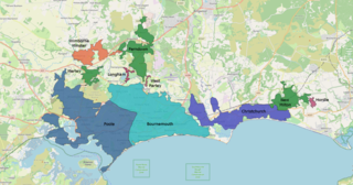
The South East Dorset conurbation is a multi-centred conurbation on the south coast of Dorset in England. The main population centres are Bournemouth, Christchurch and Poole, which together form the single unitary authority of Bournemouth, Christchurch and Poole; however, the urbanised area spreads into the Dorset unitary authority and into the New Forest District as far east as Barton on Sea. There are a number of satellite towns peripheral to these main urban centres. In clockwise rotation these include: Wareham, Verwood and Ringwood (Hampshire). The urban area is generally surrounded by a green belt.

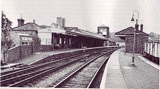
Fordingbridge was a railway station serving Fordingbridge, a small town in Hampshire. It was one of many casualties of the mass closure of British railway lines in the 1960s and 1970s. The line was officially closed on 4 May 1964, but as there was no Sunday service the last trains ran on the 2nd. It was served by the Salisbury and Dorset Junction Railway, a line running north–south, along the River Avon just to the west of the New Forest, connecting Salisbury to the North and Poole to the south, meeting the Southampton and Dorchester Railway at West Moors.
There are 22 disused railway stations in the 75 miles (121 km) between Bristol Temple Meads and Exeter St Davids, 12 of which have structures that can still be seen from passing trains. Most were closed in the 1960s but four of them, especially around Weston-super-Mare, were replaced by stations on new sites. 13 stations remain open on the line today, but there have been proposals to reopen stations at Cullompton and Wellington.

Dorset is a county in South West England. The county is largely rural and therefore does not have a dense transport network, and is one of the few English counties without a motorway. Due to its position on the English Channel coast, and its natural sheltered harbours, it has a maritime history, though lack of inland transport routes have led to the decline of its ports.

There are eleven disused railway stations between Exeter St Davids and Plymouth Millbay, Devon, England. At eight of these there are visible remains. Of the eleven stations, South Brent and Plympton are subject of campaigns for reopening while Ivybridge station was replaced by another station on a different site.

Breamore railway station was a railway station in the Avon Valley at the village of Breamore, Hampshire, England. The station was built for the Salisbury and Dorset Junction Railway and opened in 1866. It was served by trains between Salisbury in Wiltshire and West Moors in Hampshire. British Railways closed the station and the line on 2 May 1964.

Verwood railway station served the town of Verwood, Dorset, and its hinterland, from 1866 to 1964. It was one of many casualties of the mass closure of British railway lines in the 1960s; the last train running on 2 May 1964. The village is now much larger than when the line ran as it is within reasonable travelling distance of the South East Dorset conurbation.
Radipole was a railway station serving Radipole a northern area of Weymouth in the county of Dorset in England.
The Salisbury and Dorset Junction Railway was a railway that ran in the English counties of Wiltshire, Hampshire and Dorset from 1866 until its closure in 1964. Working from Salisbury, trains left the Salisbury to Southampton line at the remote Alderbury Junction. Here there was a signal box, some railway cottages and two platforms on the main line for staff use only. The line ambled south through rural surroundings to meet the Southampton and Dorchester Railway at West Moors. Trains continued through Wimborne to Poole and Bournemouth West.

The Southampton and Dorchester Railway was an English railway company formed to join Southampton in Hampshire with Dorchester in Dorset, with hopes of forming part of a route from London to Exeter. It received Parliamentary authority in 1845 and opened in 1847. It was promoted by Charles Castleman of Wimborne Minster, and became known as Castleman's Corkscrew because of the meandering route it followed.

Wimborne was a railway station in Wimborne Minster in the county of Dorset in England. Open from 1 June 1847 to 2 May 1977, it was sited just north of the River Stour in what is still Station Road. Built for the Southampton and Dorchester Railway, the station was operated from the start by the London and South Western Railway, which took over ownership in 1848. It was then operated by the Southern Railway (1923–47) and from 1948 by the Southern Region of British Railways which traded as British Rail from 1965.

Toller was a railway station on the Bridport Railway in the west of the English county of Dorset. The station served the village of Toller Porcorum. Opened on 31 March 1862, five years after the branch, it consisted of a single platform and modest wooden building.

Tattenhall Road railway station was a railway station situated a mile to the north of the village of Tattenhall, Cheshire on the Chester and Crewe Railway that was built in 1840 linking Chester to the north-west with Crewe to the south-east. The track now forms part of the North Wales Coast Line.
Bull Hill, Dorset, Daggons and Broxhill are adjoining hamlets notable for planted woodland and tree cultivation south of Cranborne Chase and West Wiltshire Downs AONB in Dorset, England. The nearest town is Fordingbridge, about 3 miles (4.8 km) ENE. They are primarily in the civil parish of Alderholt, though some of Bull Hill is in the parishes of Damerham in a north-west projection of Hampshire. The three places have indistinct borders as is normal for hamlets.

Ferry Bridge is at the beginning of the causeway to the Isle of Portland, Dorset, England, and is the point at which the Fleet lagoon joins Portland Harbour. It is situated several hundred metres south of Portland's boundary with the village of Wyke Regis, Weymouth. To the west of Ferry Bridge is the start of The Fleet, which is an internationally important nature reserve that extends to Abbotsbury Swannery, while to the east is Portland Harbour. Along the harbour side is Smallmouth Beach. The only road between Portland and the Mainland passes across Ferry Bridge.

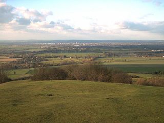
The Aylesbury Vale is a geographical region in Buckinghamshire, England, which is bounded by the Borough of Milton Keynes and South Northamptonshire to the north, Central Bedfordshire and the Borough of Dacorum (Hertfordshire) to the east, the Chiltern Hills to the south and South Oxfordshire to the west. It is named after the county town of Buckinghamshire, Aylesbury. Winslow and Buckingham are also in the vale.


