The area around present-day Dahlgren was known in the 1860s as the Shelton Precinct in Hamilton County before townships were formally established. In 1869 surveyors for the St. Louis & South-Eastern Rail Road (predecessor to the Louisville and Nashville Railroad) referred to the future town site as "Little Prairie." Construction of the railroad commenced in 1870 and was completed through the area in late 1871. At that time railroad officials applied to establish a post office in the nascent town which was to be home to the local railroad section boss. After the name "Cottonwood" was rejected by the U. S. postmaster (having already been used in Illinois) the name "Dahlgren" was assigned and the post office commenced operation on December 11, 1871.[4][5] The village was named for John A. Dahlgren (1809–1870), a U.S. naval officer prominent during the American Civil War.[6] On March 29, 1872, the official founding date of the village, A. M. Sturman executed a Deed of Dedication whereby he ceded 1 square mile of land centered on present day Main and 3rd Streets to formally layout the town. All land titles in Dahlgren derive from this original Deed of Dedication which was itself based on the original surveys conducted pursuant to Northwest Ordinance of 1787. The original settlement of Dahlgren extended roughly from the railroad depot/Chestnut St. (originally "A" Street) south to Sturmman St (originally "D" Street) and from 1st St. west to 5th St., a total of 12 square blocks.
As of the 2020 census[3] there were 504 people, 273 households, and 194 families residing in the village. The population density was 495.58 inhabitants per square mile (191.34/km2). There were 232 housing units at an average density of 228.12 per square mile (88.08/km2). The racial makeup of the village was 94.84% White, 0.40% African American, 0.00% Native American, 0.40% Asian, 0.00% Pacific Islander, 0.20% from other races, and 4.17% from two or more races. Hispanic or Latino of any race were 0.79% of the population.
There were 273 households, out of which 20.9% had children under the age of 18 living with them, 47.99% were married couples living together, 17.22% had a female householder with no husband present, and 28.94% were non-families. 26.74% of all households were made up of individuals, and 12.82% had someone living alone who was 65 years of age or older. The average household size was 3.08 and the average family size was 2.56.
The village's age distribution consisted of 29.8% under the age of 18, 3.0% from 18 to 24, 17.7% from 25 to 44, 26.1% from 45 to 64, and 23.6% who were 65 years of age or older. The median age was 44.8 years. For every 100 females, there were 89.9 males. For every 100 females age 18 and over, there were 83.9 males.
The median income for a household in the village was $50,038, and the median income for a family was $55,000. Males had a median income of $41,196 versus $24,167 for females. The per capita income for the village was $20,706. About 11.3% of families and 17.7% of the population were below the poverty line, including 30.7% of those under age 18 and 3.6% of those age 65 or over.
Commerce and transportation
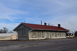
The depot in 1956 looking SE from 3rd St.
Agriculture remains the primary economic activity in the vicinity of Dahlgren. Other business activity includes retail sales and manufacturing, including the fabrication of custom cabinetry and countertops.
Dahlgren is located on Illinois Route 142 (formerly U.S. Route 460). The nearest access to the interstate highway system (I-64) is 6.5 miles (10.5km) to the northwest. The Evansville Western Railway (EVWR) (formerly CSX Transportation) provides freight rail service to Dahlgren. CSX divested 120 miles (200km) of rail line (from Howell Yard in Evansville, Indiana, to Okawville, Illinois) to the Paducah and Louisville Railway (PAL), an operating entity of Four Rivers Transportation, Inc. This was a transaction whereby CSX sold all track, ties and track equipment to PAL and provided a 20-year lease on the right-of-way. Upon completion of the sale on December 31, 2005, PAL transferred all interests to the new Class III operating entity/subsidiary, EVWR, which began operating on January 1, 2006. CSX (formerly the Louisville & Nashville R.R.) retains title to all real estate on which the railroad is situated.
The Dahlgren post office provides service to more than 1,500 customers in the 62828 postal (ZIP) code. Dahlgren has had no locally published newspaper since the cessation of publication of The Dahlgren Echo many years ago. There is no current newspaper of record as the weekly McLeansboro Times-Leader formerly published in the county seat folded in 2018. Other daily newspapers available for home delivery in the area include The Morning Sentinel (Centralia & Mt. Vernon) and The Southern Illinoisan (regional print newspaper).
Dahlgren is in the Harrisburg, IL / Cape Girardeau, MO / Paducah, KY television Designated Market Area (DMA), the 90th largest television market in 2019 as defined by Nielsen Media Research. Residents receive over-the-air reception of the following digital broadcast channels from networks and other affiliates:
ABC (WSIL) — 3.1 HD, 3.2 SD Heroes and Icons, 3.3 SD Justice Network, 3.4 SD Court TV & 3.5 SD Ion — RF channel 34
NBC (WPSD) — 6.1 HD, 6.2 SD Cozi & 6.3 SD Antenna TV — RF channel 32 (planned to be repacked to RF channel 19)
PBS (WSIU) — 8.1 HD, 8.2 SD PBS World, 8.3 SD Create, 8.4 FM Simulcast and Public Info, & 8.5 SD PBS Kids — RF channel 8
CBS (KFVS) — 12.1 HD, 12.2 HD CW (WQTV-TV) & 12.3 SD Grit — RF channel 12 (planned to be repacked to RF channel 11)
PBS (WUSI) — 16.1 HD, 16.2 PBS World, 16.3 Create & 16.4 FM Simulcast & Public Info — RF channel 19 (planned to be repacked to RF channel 23)
Fox (KBSI) — 23.1 HD, 23.2 My Network TV 49 (WDKA), & 23.3 SD Comet — RF channel 22 (planned to be repacked to RF channel 36)
TCT (WTCT) — 27.1 SD, 27.2 HD & 27.3 SD Light TV — RF channel 17 (planned to be repacked to RF channel 30)
MyNetworkTV (WDKA) — 49.1 HD, 49.2 SD Charge!, 49.3 SD TBD, & 49.4 Stadium — RF channel 49 (planned to be repacked to RF channel 25)
Since the digital television transition of 2009 there have been many ownership and affiliation changes in television markets. The Harrisburg, IL / Cape Girardeau, MO / Paducah, KY DMA has been no exception. In 2019 major players include Sinclair, Paxton Media Group, Raycom Media, Quincy Media, and the University of Southern Illinois. WPXS (Daystar), licensed to Mt. Vernon, moved its transmitter northwest of Breese, IL in the St. Louis, MO DMA and is no longer available over-the-air in Dahlgren. Viewers with a rotator and suitably elevated antenna can also receive virtually all over-the-air broadcasts from Evansville, Indiana.
Cable television service (analog), previously available from Longview Communication, was terminated in 2006. Hamilton County Communications (a wholly controlled subsidiary of the Hamilton County Telephone Cooperative - HCTC) acquired the cable-operating rights upon Longview's demise and operated an IPTV-based television service under the Futiva brand until 2019 when HCC exited the business.
Mobile telephony services are provided by ATT (formerly Cingular) and Verizon. At one time 6 providers offered cellphone coverage, either directly or through roaming agreements. This included First Cellular of Southern Illinois (which HCTC co-owned) and T-Mobile.
Local landline telephone and DSL service is available through the Hamilton County Telephone Cooperative (and/or Hamilton County Communications). Wireless broadband service is provided by all mobile providers. Satellite broadband service is available from Exede/ViaSat and HughesNet.
Dahlgren is governed by a non-partisan village president (mayor) and six-member non-partisan Board of Trustees, half of whom are elected to staggered four-year terms in odd-numbered years. Steve Wilkerson was re-elected village president in 2017. The village provides basic utility services including water, sewer, and gas and contracts on a fee-for-service basis with a third party for refuse removal.
Dahlgren is located within the Hamilton County Unit 10 school district. Elementary-age children attend Dahlgren Grade School through sixth grade. Junior high school and high school students travel to the county seat of McLeansboro, where a new combined school complex was completed in 2001. Dahlgren is also in Community College District #521 (Rend Lake College, located Ina, Illinois) as established by the Illinois Board of Higher Education. However, university and college-age students are not restricted to attending in their local district.
This page is based on this Wikipedia article Text is available under the CC BY-SA 4.0 license; additional terms may apply. Images, videos and audio are available under their respective licenses.